
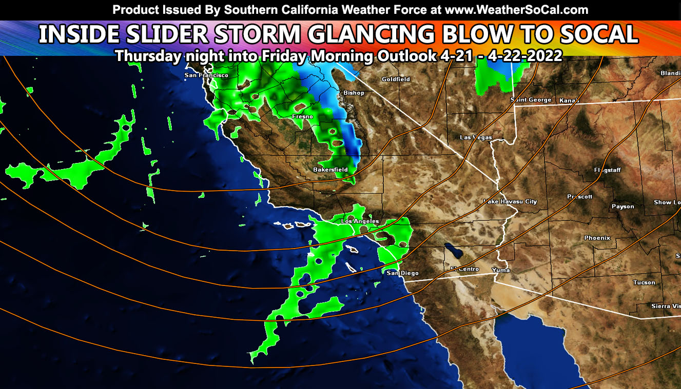
A system making a glancing blow to the north of Southern California will affect the region in a tail-end charlie frontal zone that will sweep from west to east Thursday night into early Friday morning so read on for the first outlook details …
Join the Facebook Page for Further Updates If You Have Not Yet!
SOUTHERN CALIFORNIA WEATHER FORCE MAIN:
Wind Watches are in place and have been issued over the alert system here at Southern California Weather Force today through Thursday out ahead of the main system for all mountain and desert areas. Such watches are issued without posting on the main page as the main page is more for higher end alerts and/or all articles. To join the group on Facebook that has all the alerts posted no matter where, click here. Within that you can see how to be a member as well.
There isn’t much to talk about right now about the system. The system will affect the SBA/SLO/KERN areas more than many other areas, however near the foothills and adjacent to them (west and south facing) we will contend with the upslope flow and areas like Yucaipa will see more rain than areas like say San Diego overnight on Thursday.
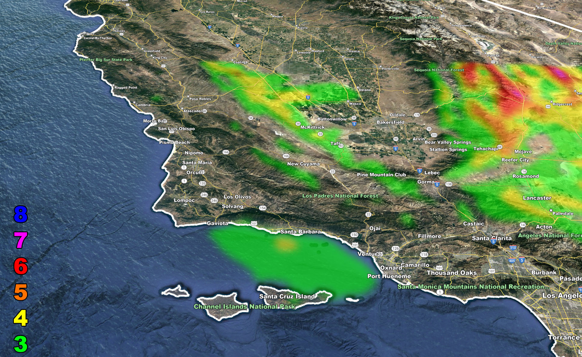
Instability factors in for areas Los Angeles and San Bernardino northward through Kern, San Luis Obispo, and Santa Barbara County. This means that thunderstorms will be possible with the system. I am targeting more for the Santa Barbara to Kern County zones at the time with the best thunderstorm risk as you have the best instability being closer to the north glancing blow of the cold air aloft, which is what creates the instability needed for thunderstorms but also upslope in the Los Angeles or San Bernardino Mountains also can pop thunderstorms off.
Unlike the last week, I do not see an issue with marine travel out in the bight (island region). The system does not have a strong enough low-level jet down there to warrant such a risk ,thus no alerts will be issued for it.
As Thursday moves along, I will be monitoring the system and getting the rain/snow forecasts out so pay attention to those, in addition to where I would be putting either a Weather Advisory or Thunderstorm Watch out … San Diego proper you look to have the least out of everyone in the metros …
Stay tuned for the Thursday updates …
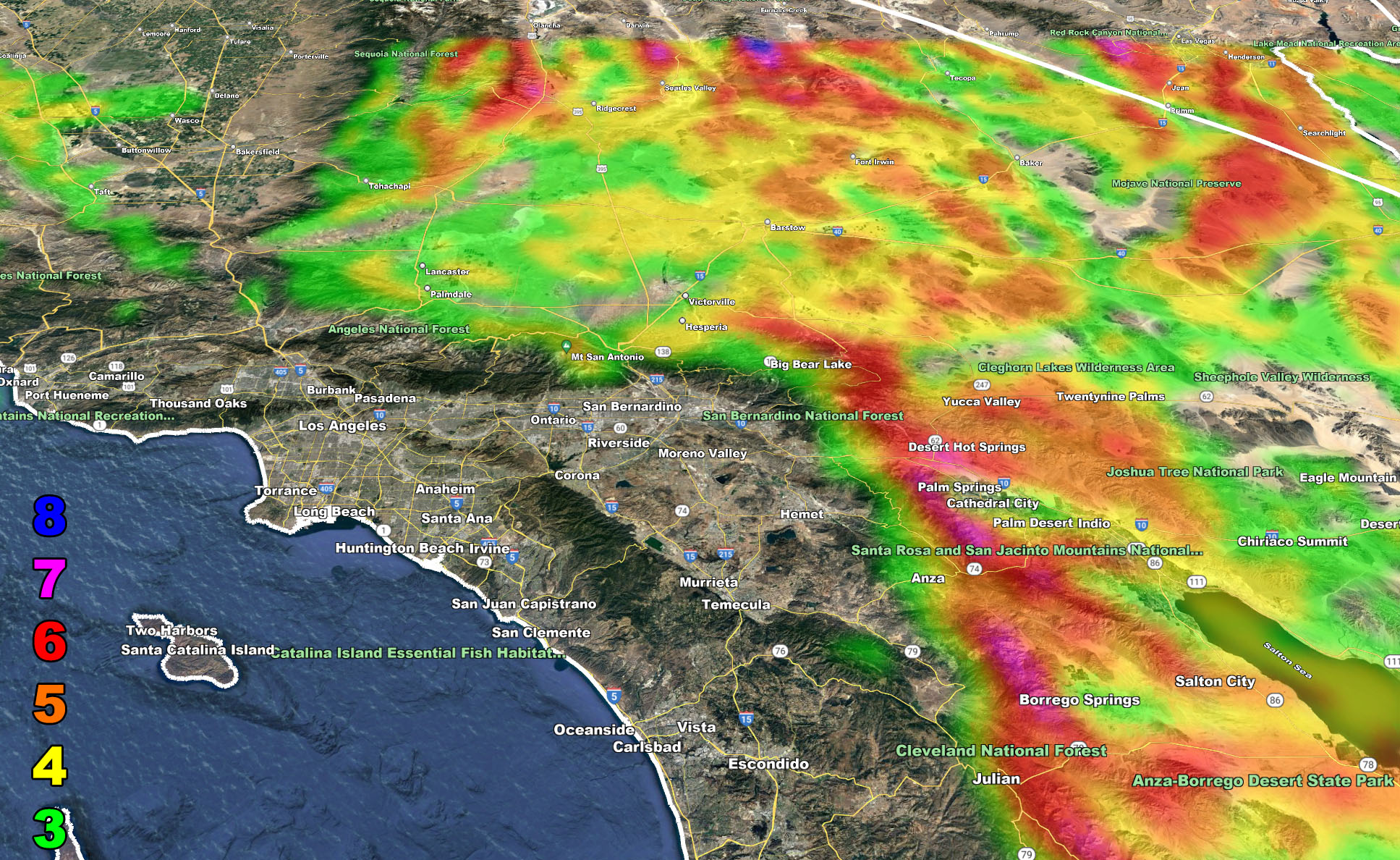
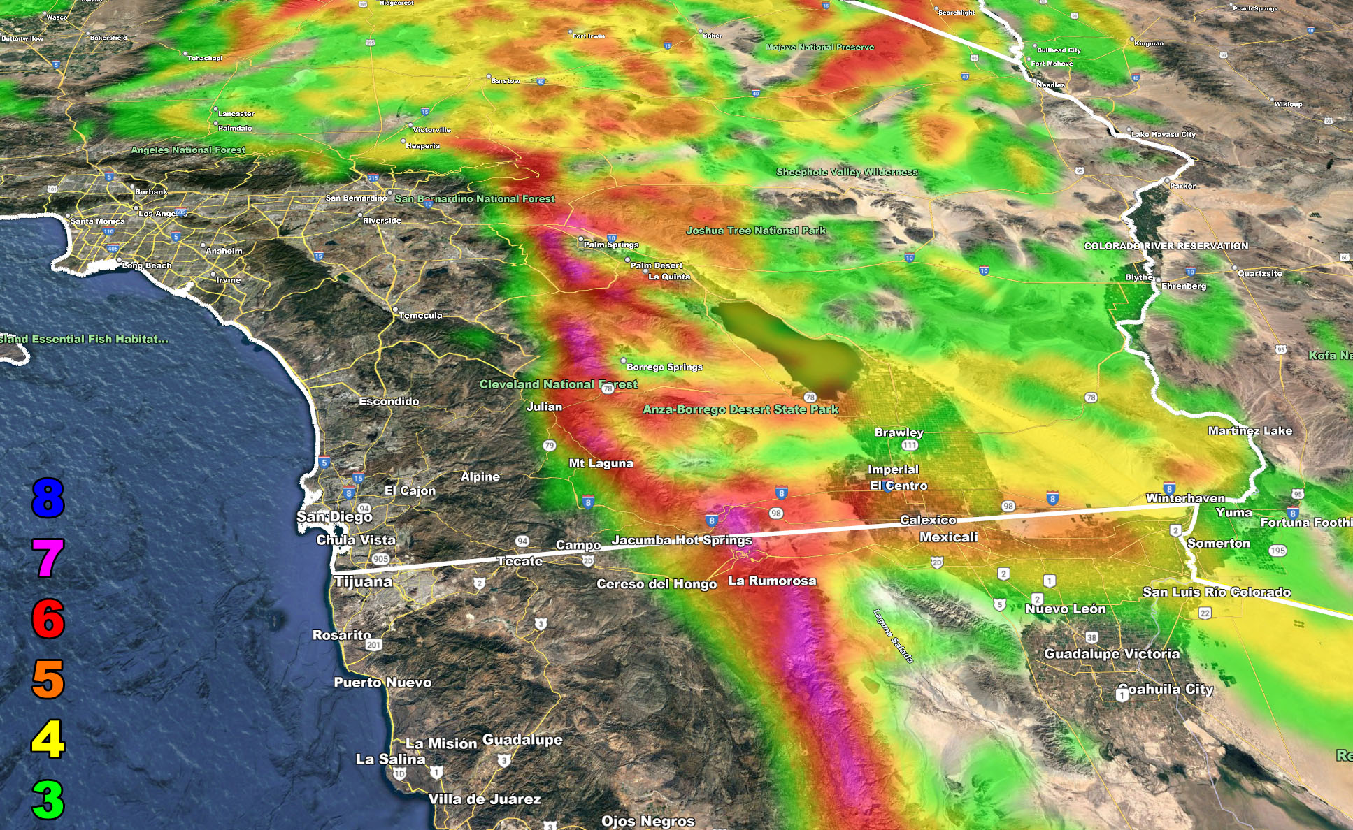
I control 10 counties in Southern California so there is a lot to say for various areas. The best I can do is let the images below speak for themselves.
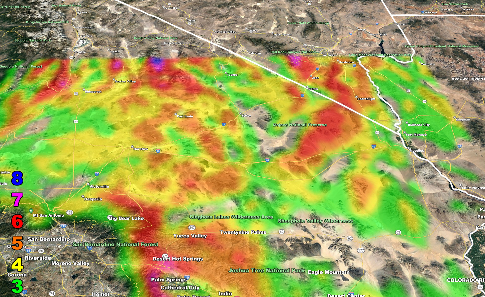
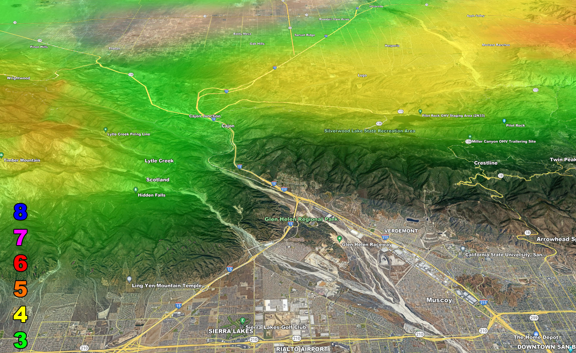
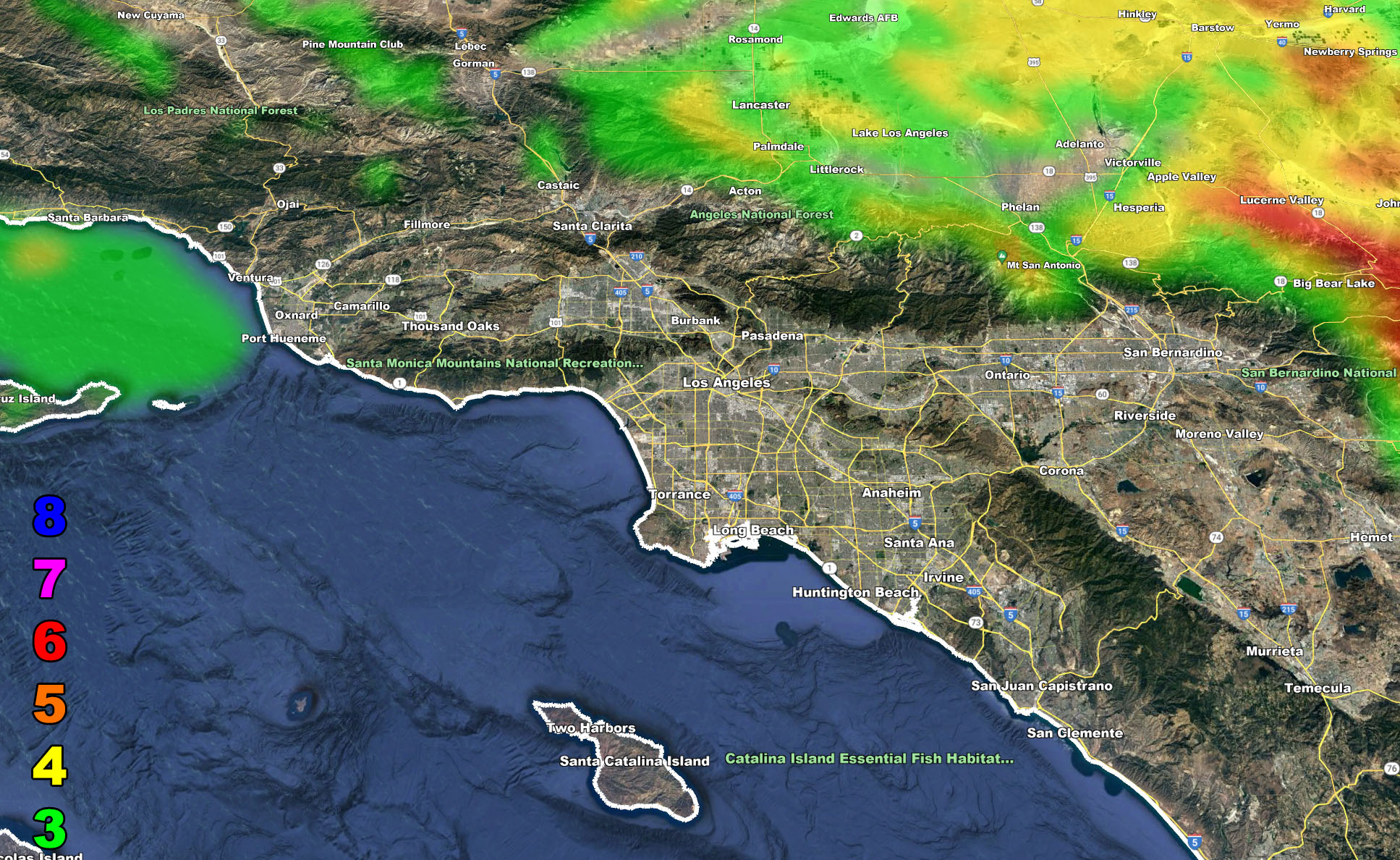
The maps below are of flood, rain, snow, snow-level, or wind intensity, whichever is available now. Each one is clickable. Map 1 is NW SoCal, Map 2 is SW SoCal, Map 3 is SE SoCal, Map 4 is NE SoCal, Map 5 is the Cajon Pass, and Map 6 is the Basin which includes LA/OC/IE and even Ventura County
GET TO KNOW YOUR MAP BECAUSE THESE NEVER CHANGE LOCATIONS
Wind Forecast – Valid Wednesday into Thursday April 20-21, 2022
MEMBERS (Click Here To Open The GPS Version Of These Maps In The Member Section)
Martin Wind Gust Intensity Scale –
8. Extensive widespread damage.
7. Trees are broken or uprooted, building damage is considerable. – High Profile Vehicle Roll-Over CERTAIN.
6. SOME Trees are broken or uprooted, building damage is possible. – High Profile Vehicle Roll-Over Likely, Do NOT recommend Traveling in this zone. This zone also is the starting zone where trees and powerlines will fall and damage cars and even kill people near or in them!
5. Slight damage occurs to buildings, shingles are blown off of roofs. HIGH WIND WARNING CRITERIA – High Profile Vehicle Roll-Over Possible if weight is not corrected.
4. Twigs and small branches are broken from trees, walking is difficult.
3. Large trees sway, becoming difficult to walk. POWER SHUTDOWN THRESHOLD DURING FIRE WEATHER / WIND ADVISORY CRITERIA
How to get these alerts with a premium subscription via e-mail by micro-climate zone AND/OR Get the GPS models for this event on your device enabled? If you read this from the website or social media links, this option is the best to go so you get them delivered every single time without having to look for them (100 percent delivery time)
Click Here To Join The Season Tier
Join The Main Southern California Weather Force Facebook Group (50 percent delivery time) – You can join the main SCWF page as well through that group.
Click Here To Join The Page Today
FACEBOOK PAGES TO JOIN!
SOUTHERN CALIFORNIA WEATHER FORCE MAIN: Southern California Weather Force Office Main Page
SOUTHERN CALIFORNIA WEATHER FORCE METEOROLOGIST: – Just my public figure page that isn’t as large so maybe you can reach me better at times.
INSTAGRAM, TWITTER, TO JOIN!
Instagram – https://www.instagram.com/socalweatherforce/
Twitter – https://twitter.com/SCweatherforce
10 mile rule: These alerts issued on this site means that within your zone and 10 miles from you will see the event forecast for. You may or may not see the event but it means you are in the zone or 10 miles from where someone will.
Southern California Weather Force is a custom weather alert service that began in September 1999 off and is regarded as the most accurate weather service in the region, offering custom alerts, maps, and models to help save life and property. The work done here is never 100% accurate, but it comes pretty close. Southern California Weather Force runs on zones, so if an event happens in a zone that is 10 miles from the border of your zone, the forecast is still valid to activate your zone’s alert system. A company quote to the public is that of “The Joker” and tells other agencies in weather this all the time… “This world deserves a better class of meteorologist… and I’m gonna give it to them”… out-forecasting even the National Weather Service with lead-time and precision, which makes this service a focus of ridicule and envy in the weather community due to having such accuracy. Alerts issued here are issued custom from this office and this office alone. You may not even hear it elsewhere, but if one is issued near or in your area, listen up because “if you do not wish to die in weather, follow, it’ll save your life one day.”