
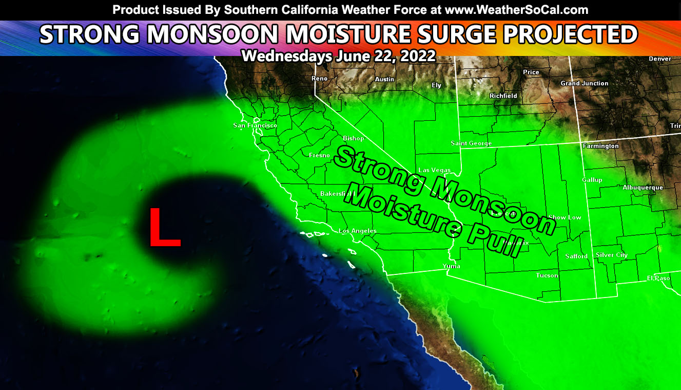
Southern California Weather Force has issued a Special Weather Statement for what I call ‘The Big Pull’ as an area of low-pressure west of the forecast area pulls monsoon moisture out of Mexico and Arizona through the forecast area on Wednesday so read on for details …
Join the Facebook Page for Further Updates If You Have Not Yet!
SOUTHERN CALIFORNIA WEATHER FORCE MAIN:
It is not often we see a strong area of low-pressure west of Southern California during the summer but this time we have it. This along with Hurricane Blas’ upper moisture streaming into Western Mexico will bring a strong surge of moisture through the region on Wednesday June 22, 2022.
We should start to see the upper dynamics affect the Imperial regions after midnight, very early Wednesday morning and the dynamics will continue to surge northeast from there over the morning and through the day. This will have to be a forecast that will be done near the day of, but it looks like from what I can see is that the upper divergence (lift) caused by this upper-low will be enough to bring showers/thunderstorms to much of the forecast area this day, including the metros. San Diego you are kind of in the ‘weaker’ area at the moment. The upper lift looks to even affect the Los Angeles areas and as far west as Vandenberg Space Force Base and San Luis Obispo, which means the rare far west forecast areas are until these dynamics this day as well.
Residents should be urged to continue to watch the skies this day if you are heading to the beach. Rapid developing thunderstorms have been known to kill those not expecting it. But… if you follow here at Southern California Weather Force and reading this now, then you know what to look for.
With the surge in moisture will come humidity, so I do also urge the sensitive to such to do what you do for that, including checking in on those you know that do as well.
Additional updates will be expected for this event … so stay tuned to official updates here at Southern California Weather Force …
Want these delivered to your e-mail and also the many other alerts for your area that area custom forecast for that you won’t see elsewhere? Sign-up for your free community paid for memberships for this season by going to this link – follow the terms of service directions as well – – https://www.southerncaliforniaweatherforce.com/?/register/CEYem5
Join The Main Southern California Weather Force Facebook Group (50 percent delivery time) – You can join the main SCWF page as well through that group.
Click Here To Join The Page Today
FACEBOOK PAGES TO JOIN!
SOUTHERN CALIFORNIA WEATHER FORCE MAIN: Southern California Weather Force Office Main Page
SOUTHERN CALIFORNIA WEATHER FORCE METEOROLOGIST: – Just my public figure page that isn’t as large so maybe you can reach me better at times.
INSTAGRAM, TWITTER, TO JOIN!
Instagram – https://www.instagram.com/socalweatherforce/
Twitter – https://twitter.com/SCweatherforce
Southern California Weather Force is a custom weather alert service that began in September 1999 off and is regarded as the most accurate weather service in the region, offering custom alerts, maps, and models to help save life and property. The work done here is never 100% accurate, but it comes pretty close. Southern California Weather Force runs on zones, so if an event happens in a zone that is 10 miles from the border of your zone, the forecast is still valid to activate your zone’s alert system. A company quote to the public is that of “The Joker” and tells other agencies in weather this all the time… “This world deserves a better class of meteorologist… and I’m gonna give it to them”… out-forecasting even the National Weather Service with lead-time and precision, which makes this service a focus of ridicule and envy in the weather community due to having such accuracy. Alerts issued here are issued custom from this office and this office alone. You may not even hear it elsewhere, but if one is issued near or in your area, listen up because “if you do not wish to die in weather, follow, it’ll save your life one day.”