
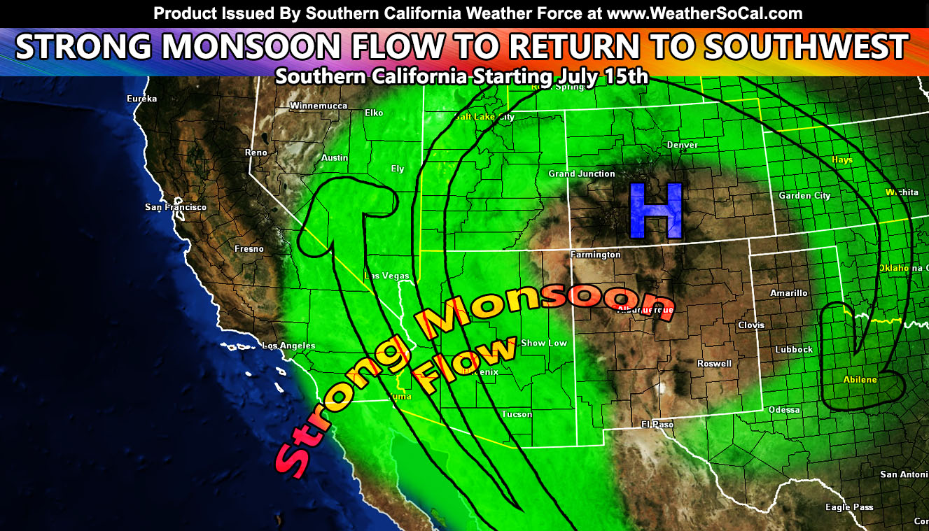
The low-pressure system that has kept the monsoon moisture east of most of Arizona will erode, bringing a ridge of high pressure over Colorado for the return of deep monsoon moisture to the Southwestern United States by mid-month so read on for details on how it will affect the prone monsoon zones of Southern California …
Join the Facebook Page for Further Updates If You Have Not Yet!
SOUTHERN CALIFORNIA WEATHER FORCE MAIN:
It will be another 7-10 days for this to fully establish, but the ridge of high pressure developing over Colorado will be in a position to bring a strong southeasterly flow in the low/mid/upper levels across the region after around July 15th but become more established after July 17th.
Because of how it is developing, kinks within the edges of this system will cause easterly waves or focus spots for the thunderstorm activity to be strongest. This should easily go as far as even the areas of Southern California, which signals this will be a strong intrusion event. We had a lot of activity in the state for June, but we have not seen much in July. This will fulfill the wonder on where the monsoon went.
The hardest hit areas will be the San Diego, Riverside, San Bernardino Mountains, including the Low Desert areas east of there along with the Las Vegas/Morongo Basin/Colorado River Valley forecast areas. Some easterly flow will also bring this west of the mountains into the San Diego/Inland Empire areas. Depending how far the flow goes, LA/OC could also be within this, but not the hardest hit zones.
Southern California Weather Force will continue to bring the latest during those times, including any alerts over the page, group, or the community supported e-mail alert system you can sign-up for freely below so stay tuned.
Remember, I have the community email alert system this season for members that was paid for with the GFM campaign. A lot was raised to keep it free this season so go ahead of sign-up at this link – https://www.southerncaliforniaweatherforce.com/wishlist-member/?reg=1598803577
If that does not work, go to the main SCWF website and hit ‘Become A Member’ in the menu and sign-up that way. It MIGHT save your life one day …
Join The Main Southern California Weather Force Facebook Group (50 percent delivery time) – You can join the main SCWF page as well through that group.
Click Here To Join The Page Today
FACEBOOK PAGES TO JOIN!
SOUTHERN CALIFORNIA WEATHER FORCE MAIN: Southern California Weather Force Office Main Page
SOUTHERN CALIFORNIA WEATHER FORCE METEOROLOGIST: – Just my public figure page that isn’t as large so maybe you can reach me better at times.
INSTAGRAM, TWITTER, TO JOIN!
Instagram – https://www.instagram.com/socalweatherforce/
Twitter – https://twitter.com/SCweatherforce
Southern California Weather Force is a custom weather alert service that began in September 1999 off and is regarded as the most accurate weather service in the region, offering custom alerts, maps, and models to help save life and property. The work done here is never 100% accurate, but it comes pretty close. Southern California Weather Force runs on zones, so if an event happens in a zone that is 10 miles from the border of your zone, the forecast is still valid to activate your zone’s alert system. A company quote to the public is that of “The Joker” and tells other agencies in weather this all the time… “This world deserves a better class of meteorologist… and I’m gonna give it to them”… out-forecasting even the National Weather Service with lead-time and precision, which makes this service a focus of ridicule and envy in the weather community due to having such accuracy. Alerts issued here are issued custom from this office and this office alone. You may not even hear it elsewhere, but if one is issued near or in your area, listen up because “if you do not wish to die in weather, follow, it’ll save your life one day.”