
Powerful thunderstorms along a strong easterly wave will move through Southern Arizona today and this associated easterly wave dynamic will make it west of the mountains by Thursday morning and continue pumping mid/upper-level moisture through Friday for the metros so read on for the details …
Join the Facebook Page for Further Updates If You Have Not Yet!
SOUTHERN CALIFORNIA WEATHER FORCE MAIN:
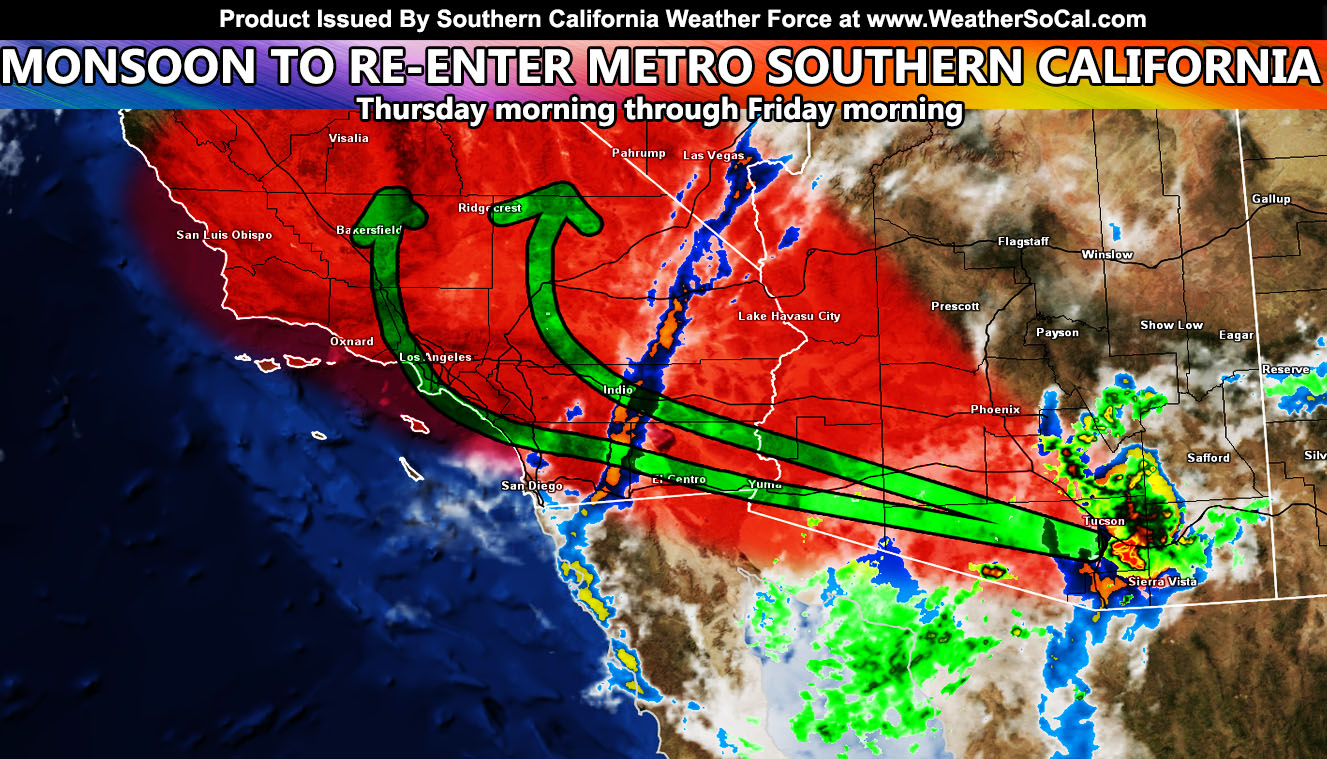
Arizona will be having an active day and night due to this easterly wave. As the high-pressure buckles, the easterly wave will be shoved westward into Southern California overnight, and by Thursday morning you will see a complete change in the sky and conditions regionwide. Showers or thunderstorms are expected to move through the metros, mainly from the Coachella Valley, Orange/Inland Empire/Los Angeles zones, but I do want to say it is anyone’s game at this point, but I will say the best dynamics will be between the two green arrows in the image above. San Diego, you have much less of a duration of passage from this wave, so you are not a real big focus spot as the others.
If you are out on the water surfing in the morning, be mindful of the lightning hazard should thunderstorms move overhead.
Additional impulses will hit overnight on Thursday, so once again the region, using the mid-level instability, will yet again have the chance of showers/thunderstorms.
Regardless, it will be an active 24–36-hour period for all sectors of Southern California, more so through the LA/OC/IE and High Desert than other areas … and … possibly even Kern (MOSTLY BETWEEN THE TWO GREEN ARROWS IN THE IMAGE ABOVE … and the humidity will be high … so if you are sensitive to such, get your preparations ready today.
Remember, I have the community email alert system this season for members that was paid for with the GFM campaign. A lot was raised to keep it free this season so go ahead of sign-up at this link – https://www.southerncaliforniaweatherforce.com/wishlist-member/?reg=1598803577
If that does not work, go to the main SCWF website and hit ‘Become A Member’ in the menu and sign-up that way. It MIGHT save your life one day …
Join The Main Southern California Weather Force Facebook Group (50 percent delivery time) – You can join the main SCWF page as well through that group.
Click Here To Join The Page Today
FACEBOOK PAGES TO JOIN!
SOUTHERN CALIFORNIA WEATHER FORCE MAIN: Southern California Weather Force Office Main Page
SOUTHERN CALIFORNIA WEATHER FORCE METEOROLOGIST: – Just my public figure page that isn’t as large so maybe you can reach me better at times.
INSTAGRAM, TWITTER, TO JOIN!
Instagram – https://www.instagram.com/socalweatherforce/
Twitter – https://twitter.com/SCweatherforce
Southern California Weather Force is a custom weather alert service that began in September 1999 off and is regarded as the most accurate weather service in the region, offering custom alerts, maps, and models to help save life and property. The work done here is never 100% accurate, but it comes pretty close. Southern California Weather Force runs on zones, so if an event happens in a zone that is 10 miles from the border of your zone, the forecast is still valid to activate your zone’s alert system. A company quote to the public is that of “The Joker” and tells other agencies in weather this all the time… “This world deserves a better class of meteorologist… and I’m gonna give it to them”… out-forecasting even the National Weather Service with lead-time and precision, which makes this service a focus of ridicule and envy in the weather community due to having such accuracy. Alerts issued here are issued custom from this office and this office alone. You may not even hear it elsewhere, but if one is issued near or in your area, listen up because “if you do not wish to die in weather, follow, it’ll save your life one day.”