

Issued Zones: Eastern San Luis Obispo County … Kern County … Antelope Valley … High Desert Metro including the Cajon Pass … San Bernardino, Riverside, San Diego Mountain/Foothills Zones … Morongo Basin … Desert Center and JTNP … Banning zones …
Site: Southern California Weather Force has issued a Thunderstorm Watch effective now through this evening …
Date Issued: 9/10/22 at 10:40am local
Forecast: First I will say that this is a demonstration of the SCWF Event Coverage Model (Below this write-up), which you see in this post. This event is NOT for the main populated regions of Southern California but is for our friends inland like the mountain/desert/kern county areas and will show you how I do things with micro-climates so let’s get started as I will checkmark every single thing today that happens in what I speak about below and where.
Tropical Storm Kay has pushed west of the forecast area, in-which as I stated in the previous update would turn the scenario into an inland type of storm scenario, a monsoon type pattern where moisture being pumped out of the south and east around the northeast periphery (lifting zone) would be the main focus. So, let’s look at the main focus spots and of course the SCWF Event Coverage Model.
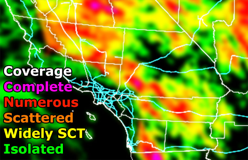
METRO HIGH DESERT / CAJON PASS: What will happen is an impulse now moving through the Coachella Valley will continue west northwestward and this will set off a chain reaction that will move off the San Bernardino Mountains and hit the metro high desert zones. As you can see from the ‘COVERAGE’ model, which is a model developed last year, the Metro High Desert is painted red, which means numerous storms will be expected there, which will cause an impact along Interstate 15 so pay attention to this warning.
ANTELOPE VALLEY: The High Desert activity will then activate the Antelope Valley forecast zones of Palmdale/Lancaster and why not let us go further north on this activation to the Edwards Air Force Base zones. The COVERAGE model show orange/red there so scattered to numerous storms will hit those zones.
KERN COUNTY: This continues to move later on into the Kern Mountain zones which will activate the mountain range and send more dynamics westward and activate storms in the Kern County Valley zones. Impact will be seen most north of Bakersfield and areas like Wasco’s zone where the ‘COVERAGE’ model shows a red value or numerous storm number. What is interesting is the model shows a green zone over Bakersfield proper with higher values all around it. This could be a record if the SCWF Coverage Model can do this and say that Downtown Bakersfield would have the weakest dynamics for this event with a lot happening around it. Long shot, but I trust this model I developed.
SAN DIEGO COUNTY: Storms south into Mexico will shove outflow boundaries northward today and activate the San Diego Foothill/Mountain zones coming out of Campo heading northwest into the Alpine area. The ‘COVERAGE’ model shows a magenta value in Mexico which means complete storm coverage and red into the regions stated above. Leakage and weakening storm activity will be likely as far west as Santee and Escondido.
SUNDAY: We have even stronger lift/dynamics for the inland areas once again. This again is not for the coast unless I state so. This again is where the monsoon typically affects.
How to get these alerts with a premium subscription via e-mail by micro-climate zone AND/OR Get the GPS models for this event on your device enabled? If you read this from the website or social media links, this option is the best to go so you get them delivered every single time without having to look for them (100 percent delivery time)
Click Here To Join The Season Tier
Join The Main Southern California Weather Force Facebook Group (50 percent delivery time) – You can join the main SCWF page as well through that group.
Click Here To Join The Page Today
10 mile rule: These alerts issued on this site means that within your zone and 10 miles from you will see the event forecast for. You may or may not see the event but it means you are in the zone or 10 miles from where someone will.
Southern California Weather Force is a custom weather alert service that began in September 1999 off and is regarded as the most accurate weather service in the region, offering custom alerts, maps, and models to help save life and property. The work done here is never 100% accurate, but it comes pretty close. Southern California Weather Force runs on zones, so if an event happens in a zone that is 10 miles from the border of your zone, the forecast is still valid to activate your zone’s alert system. A company quote to the public is that of “The Joker” and tells other agencies in weather this all the time… “This world deserves a better class of meteorologist… and I’m gonna give it to them”… out-forecasting even the National Weather Service with lead-time and precision, which makes this service a focus of ridicule and envy in the weather community due to having such accuracy. Alerts issued here are issued custom from this office and this office alone. You may not even hear it elsewhere, but if one is issued near or in your area, listen up because “if you do not wish to die in weather, follow, it’ll save your life one day.”