
Southern California Weather Force has issued a Long-Range Weather Warning effective now, starting the end of this weekend and going through this week, and into the following weekend as multiple storm systems will be expected to return, stronger than the current pattern we are temporarily leaving after today. This is an upgrade from the Long-Range Weather Advisory issued for this same period back on January 2nd so let me take you into my time machine and read on for details …
WANT THESE DELIVERED WITH ALL THOSE PERKS INCLUDING BEING ON THE MICRO-CLIMATE ALERT SYSTEM AND MODELS DURING EVENTS BECAUSE NOT EVERY ALERT IS POSTED ON SOCIAL MEDIA FROM THIS WEATHER OFFICE – JOIN TODAY BY CLICKING HERE – Southern California Weather Force Subscriber System – Southern California Weather Force
Join the Facebook Page for Further Updates If You Have Not Yet!
SOUTHERN CALIFORNIA WEATHER FORCE MAIN:
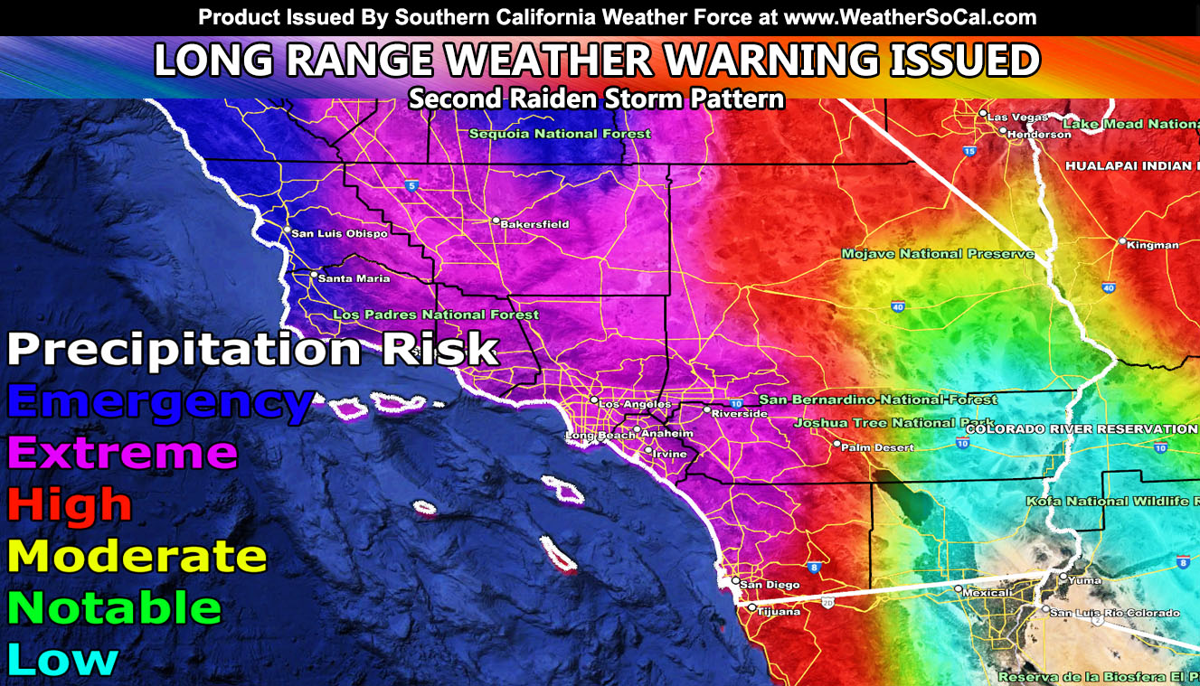
Back on January 2nd, I issued the Long-Range Weather Advisory. You can view that by Clicking Here. I feel it is prudent to go ahead and upgrade from advisory to warning as the next line of storm systems will pack an even more powerful back-to-back punch for the Southern California region. This is a second Raiden Storm Pattern. A Raiden Storm Pattern is a published forecast that is ahead of all sources available today, named after the discoverer of such a long-range pattern to come.
The series will start on Sunday, January 8th. This will be when we introduce the Pineapple Express back into the forecast area, in a zone mainly for Santa Barbara and San Luis Obispo, missing all of Los Angeles, Orange, San Diego, and the Inland Empire and surrounding mountain/desert zones within. The storm intensifies on Monday night, finally getting shoved eastward for a direct impact on all regions of the forecast area by Tuesday. This system looks very interesting as per meteorological terms it is known as a negative-tilt system. A negative-tilt system means that colder air aloft will be ahead of the front, something we rarely see. Thunderstorm dynamics will be elevated with this system along the frontal zone, that of which we have not seen yet this season.
We get that system moving out by mid-week and then by end week we do it again, with San Luis Obispo / Santa Barbara County starting off with the rain while leaving all other metros out. This system then digs south like the Tuesday system will do and then heads on in during the weekend of January 14th. This system, like the one before it, will strong as well.
These are two powerful back-to-back systems, with the storm pattern open till around January 20th when we start to see the pattern release and conditions improve. But as I stated in the forecast from October, this season will be 14-18″ of rain in Los Angeles with a median of 16″, which is an above average rainfall season. You can Click Here for that archived forecast. It will not end warm and dry as all other sources, including the all-knowing (pfft) NOAA stated. Keep that rain gear handy, we have a way to go right on into February
Southern California Weather Force will be handling the official weather watches/warnings for this coming pattern so stay tuned for whatever updates come, whether on the alert system, member section models, or social media accounts.
WANT THESE DELIVERED WITH ALL THOSE PERKS INCLUDING BEING ON THE MICRO-CLIMATE ALERT SYSTEM AND MODELS DURING EVENTS BECAUSE NOT EVERY ALERT IS POSTED ON SOCIAL MEDIA FROM THIS WEATHER OFFICE – JOIN TODAY BY CLICKING HERE – Southern California Weather Force Subscriber System – Southern California Weather Force
Join The Main Southern California Weather Force Facebook Group (50 percent delivery time) – You can join the main SCWF page as well through that group.
Click Here To Join The Page Today