
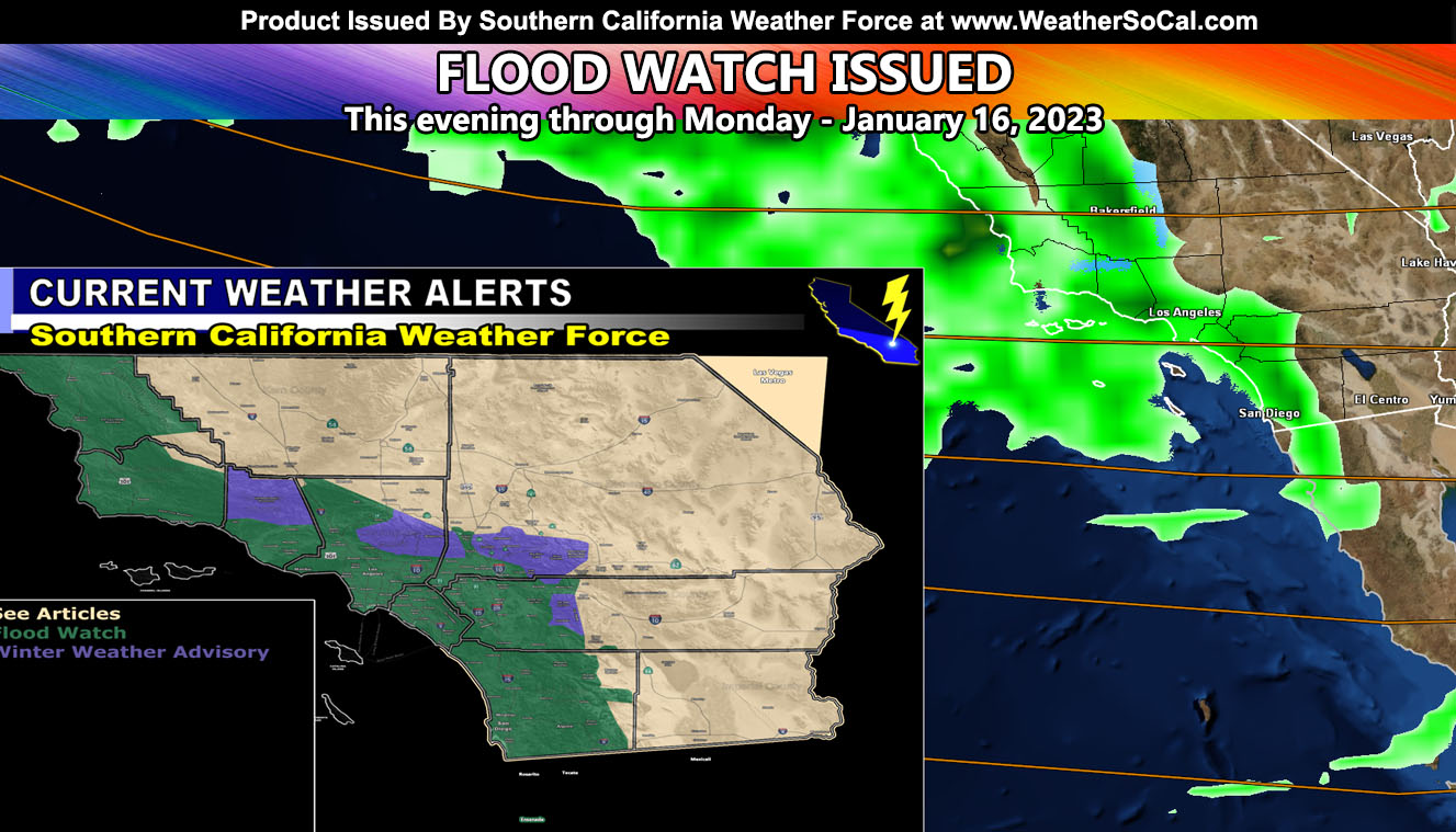
Southern California Weather Force has re-issued the Flood Watch for the coast/basin/valley areas of Southern California, effective now through Monday along with mountain snow at times so read on for details …
Join the Facebook Page for Further Updates If You Have Not Yet!
SOUTHERN CALIFORNIA WEATHER FORCE MAIN:
Latest satellite images show the next impulse that will move over the region this evening, lasting with precipitation the entire night in the watch area. Heavy rain will fall with it. Snow-levels will start out interesting, about 5,000 FT this evening but do something extremely rare. It will be snowing at that level for a bit this evening during the pre-frontal zone passage, but overnight tonight and into Monday morning we will see this snow turn to rain as the snow-levels push to 8,000 FT. They’ll go down later on Monday once again. All in all, on the ground, Big Bear could see the 6″ mark for snow, higher in the upper locations so the Winter Weather Advisory looks fine.
Cold air aloft does move in early Monday morning before or around Sunrise for parts of the Orange County, Inland Empire, and down the I-15 corridor of the San Diego County areas. This would be enough to bring a chance of thunderstorms as it does so toward the end of the heavy rainband.
Because of the various different micro-climate events expected from this system, I will only be posting this and then work with the micro-climate alerts over the e-mail alert system when needed. Members, the GPS models are down for this system due to a coding error from the server, but it is being worked on.
SEASON RAINFALL THUS FAR: Back in the Fall I issued the forecast for the season that would see average to above average rainfall. Average is in the 14″ rain mark for Los Angeles. My forecast was for 14-18″ with a median of 16″. You can read that forecast archive by Clicking Here. So far this season, counting all the months including this one thus far, Downtown Los Angeles has received 12.54″ of rain, with another 2″ on the way for the next couple of systems combined over the next 5 days, this one and the fast moving one on Thursday. We still have a couple months left to push that even further up. We are now out of extreme drought as I type this.
LONG RANGE: As stated in the Long-Range Weather warning in the link above, we will lose the current storm pattern by January 20th or around there. But we still have a long way to go through February with the next expected pattern starting by end month or the first week of February. We are going to see a Santa Ana Wind Pattern for cold arctic style Santa Ana Winds on the week of January 22nd.
WANT THESE DELIVERED WITH ALL THOSE PERKS INCLUDING BEING ON THE MICRO-CLIMATE ALERT SYSTEM AND MODELS DURING EVENTS BECAUSE NOT EVERY ALERT IS POSTED ON SOCIAL MEDIA FROM THIS WEATHER OFFICE – JOIN TODAY BY CLICKING HERE – Southern California Weather Force Subscriber System – Southern California Weather Force
Join The Main Southern California Weather Force Facebook Group (50 percent delivery time) – You can join the main SCWF page as well through that group.
Click Here To Join The Page Today