
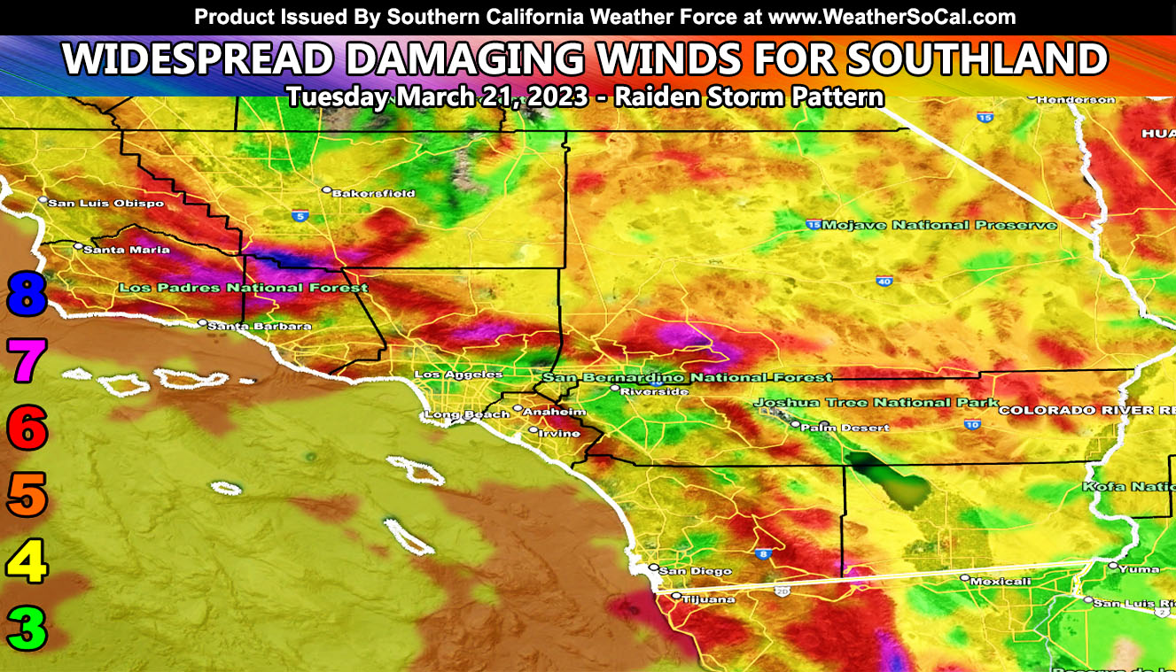
As stated in the previous update, this system will have widespread gusty and damaging winds across the entire Southern California Weather Force jurisdiction and this is the update to it, including the Raiden Storm Wind Intensity Maps for Tuesday March 21st, 2023. It is urged that if you are in a level 4 or higher on the coming maps to know you are within an area that power poles/lines and trees can come down, which increases erosion and mud/landslide danger so read on for details …
Join the Facebook Page for Further Updates If You Have Not Yet!
SOUTHERN CALIFORNIA WEATHER FORCE MAIN:
SPRING 2023 MEMBERSHIP TIER OPEN – WANT THESE DELIVERED WITH ALL THOSE PERKS INCLUDING BEING ON THE MICRO-CLIMATE ALERT SYSTEM AND MODELS DURING EVENTS BECAUSE NOT EVERY ALERT IS POSTED ON SOCIAL MEDIA FROM THIS WEATHER OFFICE – JOIN TODAY BY CLICKING HERE – Southern California Weather Force Subscriber System – Southern California Weather Force
DISCUSSION: This system was officially designated a Category Five storm out of the one through six scale here at Southern California Weather Force. This means that heavy precipitation, wind damage, and thunderstorm chances will all be part of the risk for the passage of the system.
This system does have a feature that will accelerate the wind damage across the region for your Tuesday. On Tuesday morning, a surface low embedded within the storm system’s ‘exit region’ of the upper-level jet will act like a mini bomb cyclone. This deepening of this small but potent area of surface low pressure will move through the bight (island region) of Southern California and come during the morning hours. This will bring in a strong gradient into it from all sides and thus you will have the winds rapidly increasing.
This will also cause all airports to have reverse operations. Meaning LAX will land out from the ocean and takeoff toward the land. If you live east of the airport, prepare to have a noisy morning.
These winds will turn onshore overnight and weakening in all sectors as the surface low moves further inland and weakens.
This will be about 18 hours’ worth of an event wind-wise.
WINTER STORM WATCH: In the previous update I was monitoring the mountains and how the system would come in. I did decide that the Los Angeles and San Bernardino Mountains above 5,000 FT will see heavy snowfall Tuesday through Wednesday and thus the official Southern California Weather Force Winter Storm Watch went out this morning at 10:00a.
Click Here To Read That Alert
Yesterday’s article took care of all the alerts thus far you see. The Flood Watch expands all areas south and west of the mountains below 4,000 FT. The Marine Weather Warning for gale force winds and large swells is for the enter bight (island region). And I did have the entire area in the wind watch yesterday for Tuesday, which is the update you are reading now.
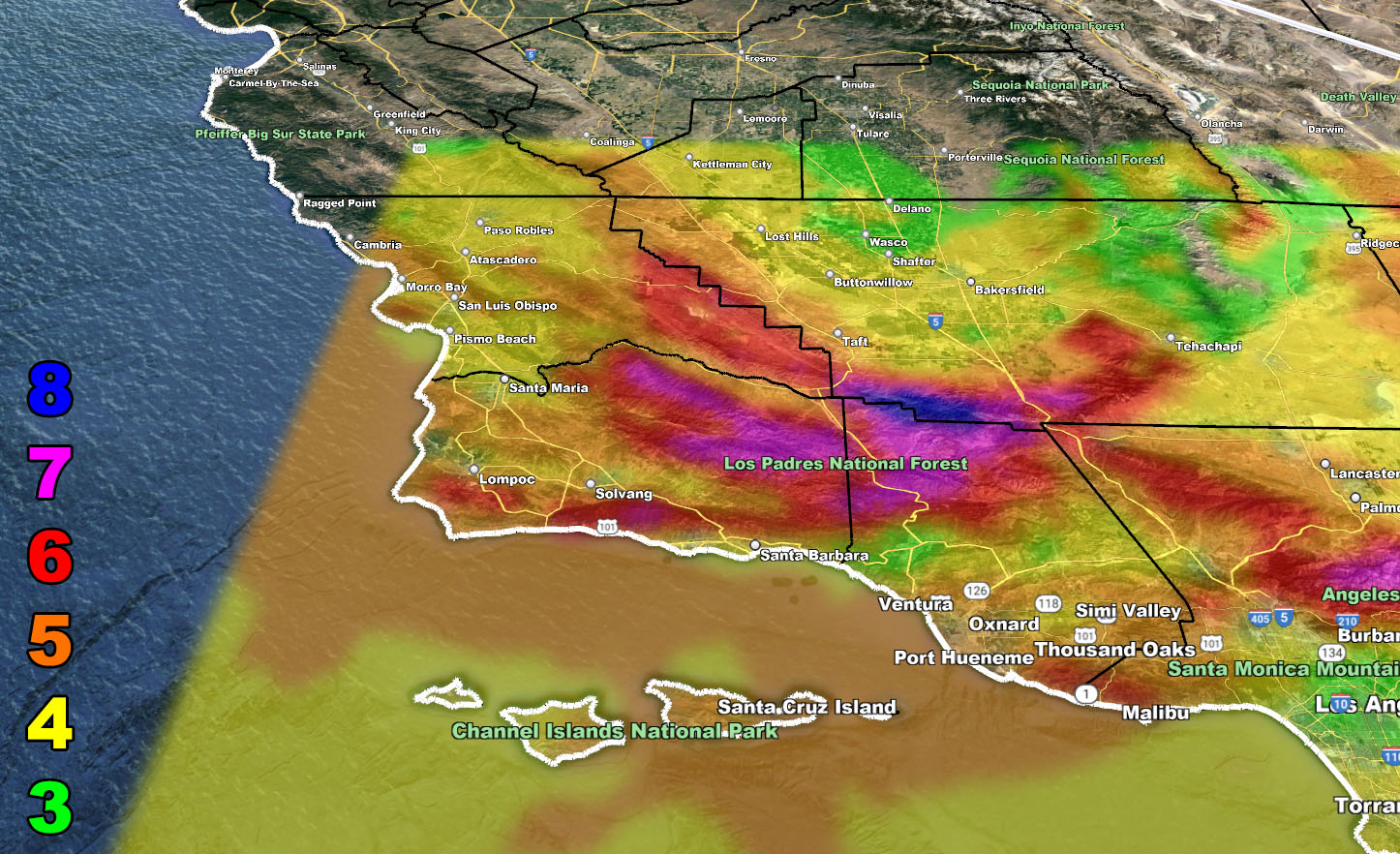
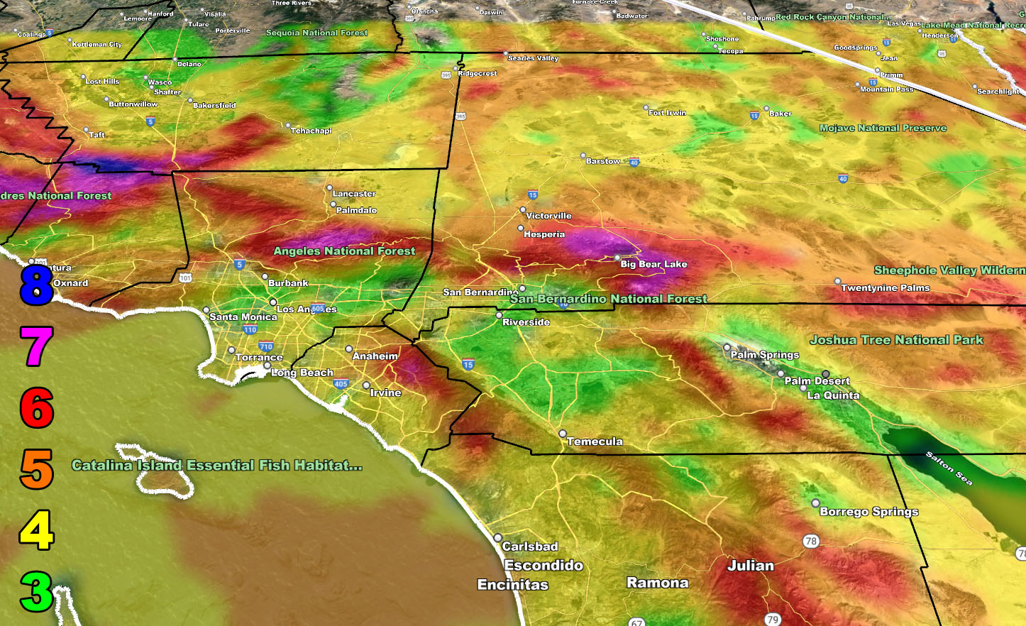
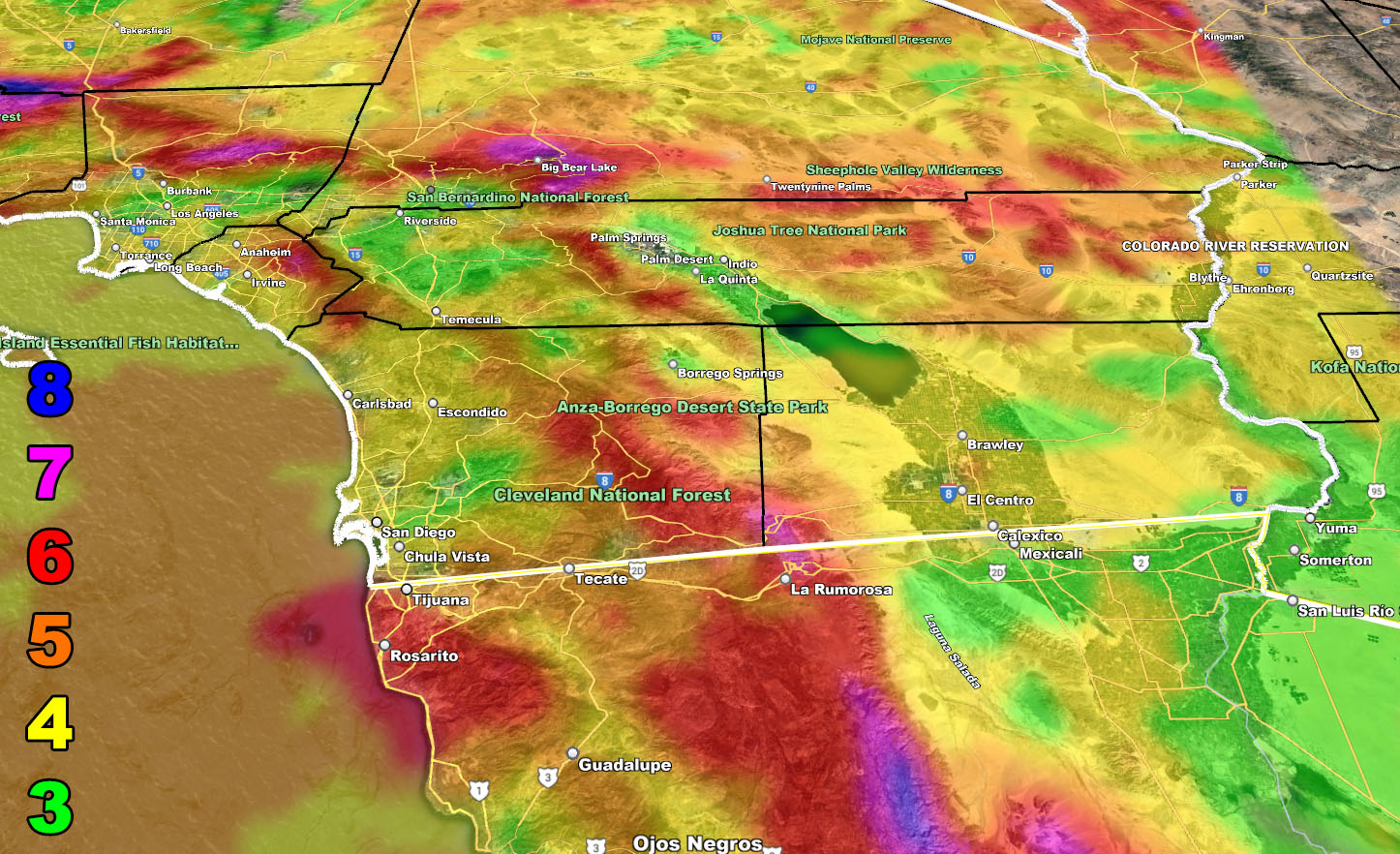
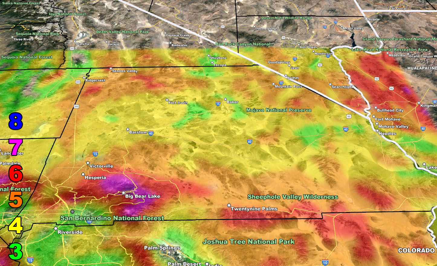
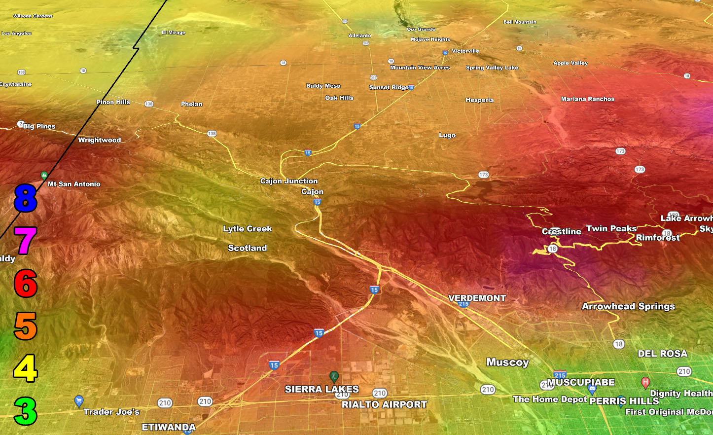
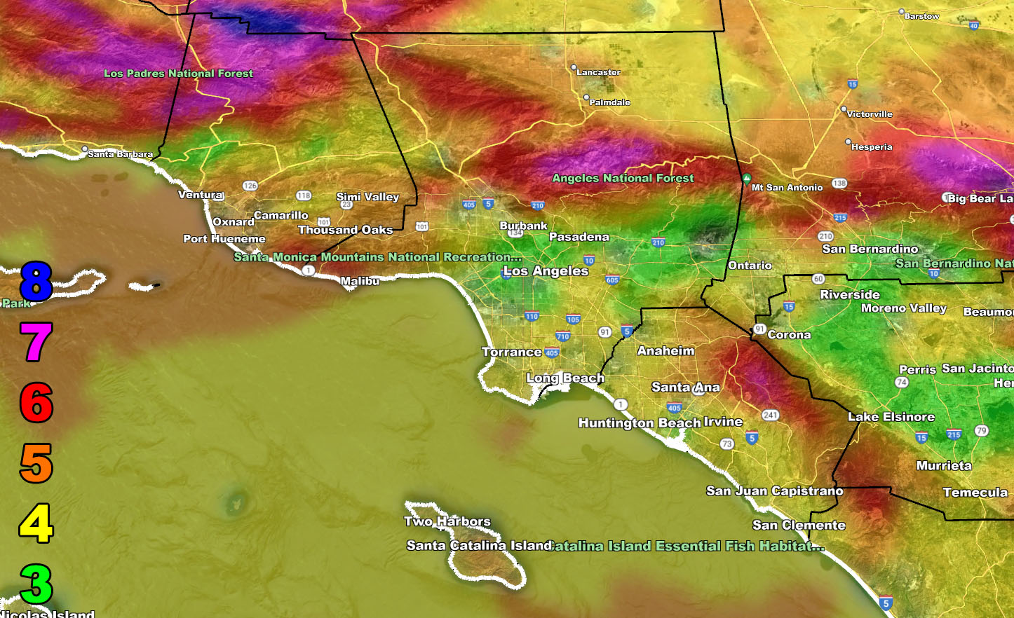
Use the information below for the Raiden Storm Wind Intensity Model effective from 6am Tuesday morning through 11pm Tuesday night.
FINAL RAIN, SNOW, WIND MAPS WILL BE OUT TOMORROW (MONDAY 3-20-2023) – CHECK BACK THEN
NOTE: SCWF does not have customer service with a person. If you need help with your accounts and/or signing up for this service, use the AI Bot in the ‘Weather Center Support’ feature on the lower right of this page.
Wind Model – TUESDAY MARCH 21, 2023
SUPPORTING MEMBERS: Click Here To See The GPS Version Of This Model In Your Member Section Tab.
Raiden Storm Wind Gust Intensity Scale –
8. Extensive widespread damage.
7. Trees are broken or uprooted, building damage is considerable. – High Profile Vehicle Roll-Over CERTAIN.
6. SOME Trees are broken or uprooted, building damage is possible. – High Profile Vehicle Roll-Over Likely, Do NOT recommend Traveling in this zone. This zone also is the starting zone where trees and powerlines will fall and damage cars and even kill people near or in them!
5. Slight damage occurs to buildings, shingles are blown off of roofs. HIGH WIND WARNING CRITERIA – High Profile Vehicle Roll-Over Possible if weight is not corrected.
4. Twigs and small branches are broken from trees, walking is difficult.
3. Large trees sway, becoming difficult to walk. POWER SHUTDOWN THRESHOLD DURING FIRE WEATHER / WIND ADVISORY CRITERIA

Join The Main Southern California Weather Force Facebook Group (50 percent delivery time) – You can join the main SCWF page as well through that group.
Click Here To Join The Page Today