
Southern California Weather Force has issued an update to the Super Long-Range Forecast for this season’s El Nino.
If you have been following, you know that here at Southern California Weather Force the forecast was for a strong El Nino. But, El Nino does not mean rain at all for Southern California.
As for the short and medium range … Santa Ana prone zones will be active Friday night into Saturday, then again STRONGER this next week as we remain in a slider pattern to the north. Southern California Weather Force will not work on NOAA’s way of El Nino vs. Rain in this area.
This is from the following article on the below link (Reference A Below) – Which will stand for this season.
Just because an El Nino is called does not mean El Nino means more rain for the Southwestern United States. Just last year, I called La Nina to be above average in rainfall and every other thought it would be drier and look what happened.
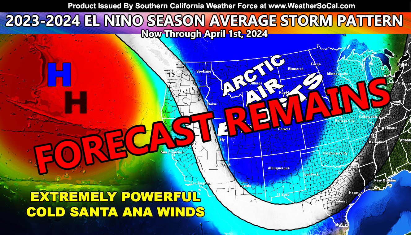
I recently called a season where we have a very strong Eastern Canadian low and a strong ridge of high pressure in the Northeast Pacific Ocean between Alaska and Washington State.
This combination would bring a strong northwest to southeast jet out of the north and provide the Desert Southwest with extremely cold temperatures as an average, even having record low temperatures across the entire region. This will be coming soon.
One thing I saw is this pattern would have a strong temperature gradient along with upper-level jet dynamics to bring some of the strongest and coldest Santa Ana Wind Events, numerous in fact. We have not seen these for many years now, but this year should easily bring these, which they have and will continue to.
The first of the Santa Ana Winds I said would start just before Halloween as previous stated in my initial forecast for this winter, which again has not changed. This should be a couple days give or take a day just before Halloween, which did happen.
Get used to it, these winds will be the center of attention for most of this season. We will still have average to below average rainfall, but I do not see it being extremely dry. Still, I see a good 8-14″ of rainfall, with 10″ being the margin in Los Angeles for this season along with low-elevation snowfall events, which is not an El Nino, more of a La Nina in terms of what ‘their’ definition is.
In Addition to this pattern, rogue storms within the pattern would set up across Southern California and then move south into Northern Mexico, which will put this season average for Phoenix and above average in precipitation for Tucson, and areas north being average to below.
That is the forecast for Southern California, which again is way different than what El Nino should provide according to records. However, I’ve said this before ‘they’ (NOAA idgits) base El Nino and La Nina off the strong events of 97-98 and 98-99, with no real research on other years and they ALL should be ashamed of their intern years against ME.
Master General Meteorologist – Raiden Storm
Get these alerts over the new Android and Iphone app and/or e-mail service by becoming a full member subscriber today and never miss an update from this office. Remember, you cannot just make an account on the app and get notifications. You must select your zones and then go through the payment process.
ALSO IMPORTANT: Once you set your zones you will see notifications being BLANK UNTIL YOU GET AN ALERT. You are new on the member app, it doesn’t know you from past notifications. So just because it is blank in the beginning of service does not mean it does not work.
Click here to learn more.