
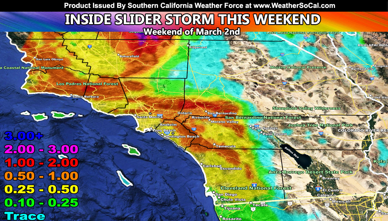
A storm system that will brush Southern California from the north will move in Friday night through Saturday, mainly affecting the metros.
This system sweeping out of the Pacific Ocean will start west of Los Angeles and Ventura on Friday night, moving across the metros of Los Angeles, Orange, Inland Empire, and San Diego’s forecast area and adjacent mountain and desert zones on Saturday.
Projections are a bit all over the place right now on the exact track of the system, but based on the current satellite images along with the Southern California Weather Force rainfall prediction model, it looks like it will deliver the most precipitation on the southern slopes of the Los Angeles and San Bernardino Mountains on Saturday, given the onshore flow (southwest to northwest) component where over an inch of rain is to be expected.
The snow-level will be around 6,000 FT west of Los Angeles, and 4,000 FT north of it in the Kern County Mountains, but the moisture depth profiles will be looked into. Tehachapi could end up with near 2″ of snowfall at airport level while Big Bear Lake would be a dusting. Or it could be more on both ends, so the moisture depth will be monitored up till the final forecast update.
Stay tuned to Southern California Weather Force for more updates on this and other future events.
– Raiden Storm –
https://www.southerncaliforniaweatherforce.com
Master General Meteorologist – is a consulting meteorologist for over 50 companies, including energy, agriculture, aviation, marine, leisure, and many more areas. He has certs from Mississippi State for broadcast met and Penn State forecasting certs MET 101, 241, 341 and 361 as a meteorologist, but before then was completely self-taught, barely learning a thing from the schools that he did not already know.
Both short and long-range is very important to know in those jobs so you can bet on accuracy here. He is versed in fields like Western USA, Tornadoes, Floods, Hurricanes, High Winds, Fire Behavior, Snow and Blizzards, Short Range, Long Range, Seasonal, and Life-Threatening decisions with over 25 years’ experience, out forecasting all weather services available today with lead-time and precision, which makes him a focus of ridicule and envy.
NOTE: Alerts are posted on here, be it a tornado watch, etc, and these alerts are issued from this office and nowhere else. At times, which is often, you will see an alert forecast posted on here that you do not see elsewhere.