
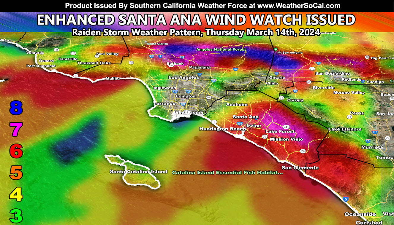
Southern California Weather Force has upgraded the Long-Range Weather Advisory to an official Enhanced Santa Ana Wind Watch for what looks to be the strongest offshore (Santa Ana Wind) pattern this season, centering Thursday, March 14th, 2024.
On March 7th, a Long-Range Weather Advisory was issued here at Southern California Weather Force (Reference A Below), outlining the coming event a week out. As the advisory stated, “A storm system coming down out of the north would miss Southern California to the east, giving Arizona the renewed storm dynamics. This system has strong upper support with it as we will be on the western periphery. This usually means that strong northeast to southwest winds will extend from the upper levels, down into the lower levels. This is pretty rare for Mid-March, usually these winds are Fall and Winter type.
However, anytime you get a strong system giving a glancing blow to the east, you can expect these winds. Hardest hit areas will be from Ventura County, SCV, SFV, Orange County, and the Inland Empire areas, including the Cajon Pass and even to the San Gabriel Valley. We will have trees down with this one where the areas of over a level 6 exist on the image within this post. Keep in mind that these northerly winds do not affect Downtown San Diego as you would need an easterly component.
Cajon Pass: If you drive a high-profile vehicle, it is extremely urgent you do not get to the 210 and 15 interchange, in-which we will see numerous roll-overs on Thursday morning.
Zoom in maps may be available on Wednesday for this event, but for now the levels will remain on the current SCWF wind model.
LONG RANGE: Monitoring this pattern to shift a bit to the west after March 20th for another system out of the north for the forecast area. No advisories will be issued for that yet, but I will be monitoring it.
An Enhanced Santa Ana Wind Watch means that an update to an earlier advisory (the one I issued on the 7th) has been issued and monitoring of the event has brought it to certain, with the hardest hit zones at a level 8 on the Raiden Storm Scale.
Reference A – (Initial first call of this event) – https://www.southerncaliforniaweatherforce.com/2024/03/07/long-range-weather-advisory-issued-possible-strong-santa-ana-wind-event-within-a-week/
Stay tuned to Southern California Weather Force for more updates on this and other future events.
– Raiden Storm –
https://www.southerncaliforniaweatherforce.com
Master General Meteorologist – is a consulting meteorologist for over 50 companies, including energy, agriculture, aviation, marine, leisure, and many more areas. He has certs from Mississippi State for broadcast met and Penn State forecasting certs MET 101, 241, 341 and 361 as a meteorologist, but before then was completely self-taught, barely learning a thing from the schools that he did not already know.
Both short and long-range is very important to know in those jobs so you can bet on accuracy here. He is versed in fields like Western USA, Tornadoes, Floods, Hurricanes, High Winds, Fire Behavior, Snow and Blizzards, Short Range, Long Range, Seasonal, and Life-Threatening decisions with over 25 years’ experience, out forecasting all weather services available today with lead-time and precision, which makes him a focus of ridicule and envy.
NOTE: Alerts are posted on here, be it a tornado watch, etc, and these alerts are issued from this office and nowhere else. At times, which is often, you will see an alert forecast posted on here that you do not see elsewhere.