
Southern California Weather Force has been monitoring a cutoff low from Hawaii over the last week. Since it is a cutoff low, daily observations must be taken into consideration while trying to deliver the most probable forecast.
The center of the dynamics was always going to be the state of Arizona, where I have issued a Flood Watch over at the Arizona Weather Force.
Link to article – https://www.facebook.com/ArizonaWeatherForce/posts/pfbid0Jq2Vn5bTgMRwDjBa4eLmn1pwed1hWRS8NN9Grm3kVkqbvddwgGs1tXU9t2Jr99Trl
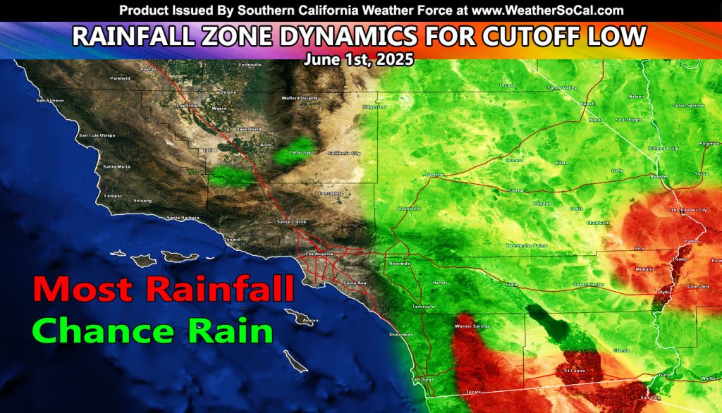
But for us in Southern California, we will go ahead and maintain that the eastern half of the forecast region will be in the shower and storm dynamics with the passage of the cutoff system, mainly on Sunday.
Indications are that the low-levels of the atmosphere will be somewhat dry. This means that in order to get rain to actually fall to the ground and be noticeable, you would need to be higher up in elevation, which makes a lot of sense given the closer to the base of the clouds you are, the better chance rainfall won’t evaporate before it hits the ground.
Sunday is the peak day as outflow boundaries move out of Baja, Mexico and into Southern California, igniting the San Diego, Riverside, and San Bernardino Mountain locations within the most rainfall, including the southern half of Imperial County.
For the rest of the region, activity could move toward San Diego and the Inland Empire, however at this time the flow will be too weak to sustain anything worthy of a write-up.
SATURDAY: Will be making the final forecast alerts and map info if needed.
MEDIUM RANGE: Monitoring another system from Alaska that will come down here by next week, centering Tuesday, June 3rd, 2025. More on this will be given, but it seems as if it has a better handle on some of the metros than this current one will.
Raiden Storm
Master General Meteorologist