
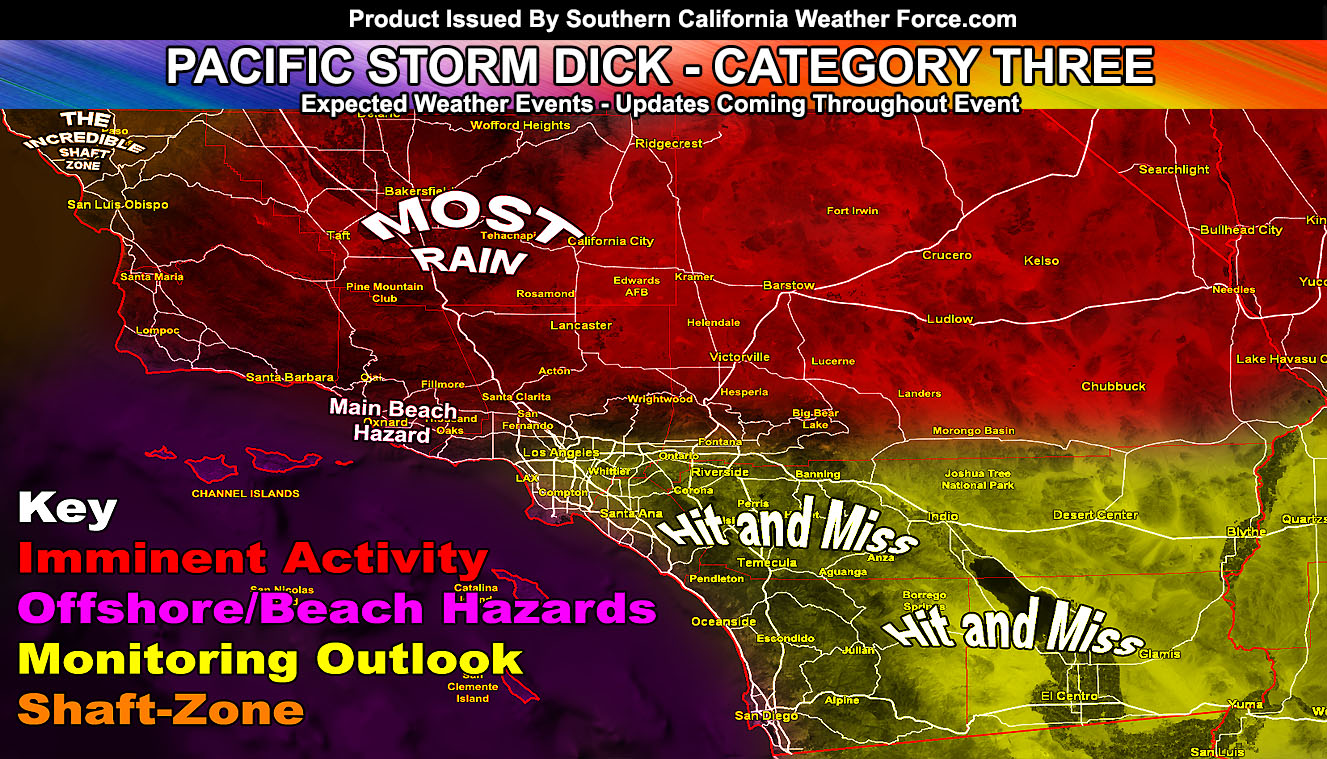
Pacific Storm DICK has officially been announced and he will soak some of the areas northwest of Los Angeles tonight into Friday where my Flood Advisory and Warning products were issued over the micro-climate alert system this morning. He will deliver hit and miss shower and thunderstorm activity to the metros and the rest of Southern California through Saturday but for your area’s details keep reading on …
Welcome to Southern California Weather Force on Pacific Storm DICK. The system will be a category three system due to the widespread thunderstorm activity expected in the areal forecast area for a prolonged period of time at times. The areal forecast area is 10 counties from San Luis Obispo, Kern, Los Angeles, San Bernardino, Riverside, Imperial, San Diego, Orange, Ventura, and Santa Barbara. That does NOT mean that all will see thunderstorms. This is a cutoff system and I would say the majority of them will. Already, as stated in the previous article (Click Here To Read That), The forecast for areas north of San Bernardino and Los Angeles metro would see thunderstorms forming as early as Thursday, which is today. Currently, widespread thunderstorms are forming, one hitting Barstow as I type this.
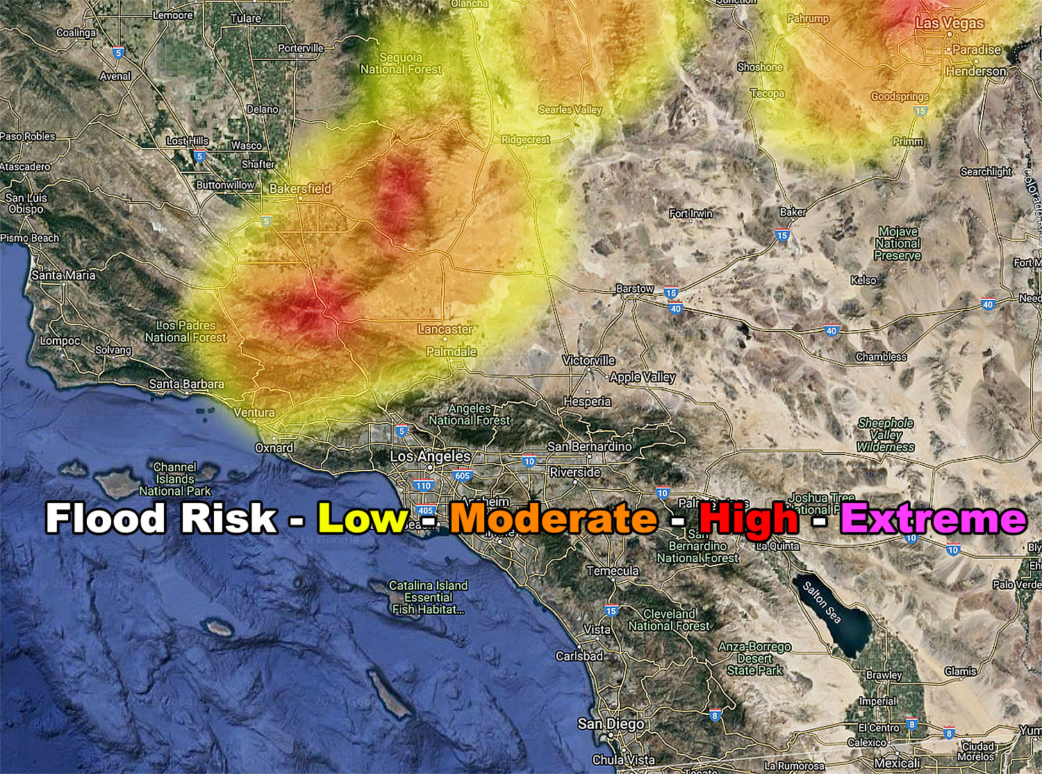
I have issued a Flood Advisory and Warning for the following areas in the near-term; Kern Mountains and Gorman Pass … Kern Valleys Taft to Bakersfield … Kern Deserts … Kramer Junction … Antelope Valley … Castaic to SCV … Ventura County, excluding eastern basin … Santa Barbara Mountains …and it reads; A cutoff system will move into the region later today, mainly overnight tonight and into Friday evening. The onset of the system will bring about very strong lifting overnight tonight. This will place the upper system in the northwest forecast area, northwest of the advisory/warning zones. The upper divergent section will bring fast developing showers and thunderstorms to the region then and through the entire day on Friday. The strongest cells will be capable of producing torrential downpours, which will bring a flood risk. The SCWF Flood Risk Model (Shown in this advisory) shows that the majority of the zone will have a moderate risk flooding, the exception of low risk in the Santa Clarita to Ventura proper zones. You are close to the moderate risk zone so the 10-mile rule applies and thus you’ve been issued the advisory as well. NOTE in the model that Bakersfield and Taft will be the northwest most zone for flooding and that the Northern Kern Valley near Delano will not be in this. This is how precise SCWF models are. Furthermore, note that the PMC/Cuddy Valley/Gorman and Tehachapi zones are in the high-risk zone.. thus a warning … The flood risk will end on Friday night as the system reaches the center of the Martin Storm Diamond and begins to affect areas Los Angeles southeastward toward San Diego and the Inland Empire, which is out of this advisory area.
NOTE: That alert was issued well before you read this article over the micro-climate alert system. There are TWO ways to get them so follow one or both of the links below.
100% effective delivery: Micro-climate e-mail alert system from this weather service: Click Here For Details.
50% effective delivery: Facebook groups in your micro-climate: Click Here To Find Yours
As for what we will be looking for on your Friday and Saturday, the system will move directly into the Martin Storm Diamond yes, however, the passage does happen on Friday night during non-peak heating hours so this would impact lesser risks of widespread flooding and thunderstorms to the metros. The metros, however, will see the chance of those showers and thunderstorms Friday into Saturday so don’t think it will just pass. The latest precipitation model here at Southern California Weather Force does continue to show less precipitation for the LA metros with more in the mountains and inland.
FRIDAY DETAILS
On you Friday, expect the area of diffluence to reach Ventura metros to the Santa Clarita Valley. This should happen by early Friday morning right around sunrise and increase over the morning toward the Santa Clarita Valley zones as the north to south orientated lift-zone sags southward with the center of the low. Activities such as boating, fishing, swimming, or surfing must be halted during this period anywhere near the Ventura County Coast as lightning will be striking out there then so be advised. The same will be the timing for the San Luis Obispo and Santa Barbara County zones, later Friday morning into the evening. This article will serve the wording in your area as an ‘alert’ word, but if I need to add anything one will go out for you.
As the day moves along through mid-morning, the secondary spiral arm-band of Pacific Storm DICK will bring thunderstorm activity from the Big Bear/Landers convergence zone, north-northwest directly into Barstow, which would affect areas around Lucerne Valley as well. This will be a line of training thunderstorms. Training thunderstorms are storms that hit one after the other and they will do so in this fashion and in those zones most of Friday. As the outflow from those kicks east during the afternoon, we will see thunderstorms popping up along Highway 62 in the metro zones of the Morongo Basin as well as the Twentynine Palms Marine Base. We could get a pop-up thunderstorm in Wrightwood or very near it at this time as well.
There will be a dry slot between Ventura/LA and Barstow so somewhere probably along I-15 in the Victor Valley and Hesperia zones will be people wondering where this storm is when it will be nailing other areas north, east, and west of you. Stable air advecting out of the Inland Empire at that time will keep activity isolated to nil there.
The Antelope Valley will hear the first clap of thunder (you heard a sonic-boom today at 5:19 pm) between 1 am and 4 am is what I will target. You are on the fringe of the flood advisory zone for low/mod risk flooding.
The system moves south of the Martin Storm Diamond by Saturday and introduces the zone with strong divergence aloft in all areas, kind of acting like a monsoonal event where the elevated zones and nearby foothill/valley zones would see activity popping up on the convergence zones, including the Elsinore Convergence Zone, while areas away from those would not see much. Saturday will be a tricky forecast, but I’ll let the wording stand and work with it on Saturday morning for the micro-climate alert discussion. The upper low is a cutoff and has time to veer.
So, in short here is the breakdown.
Hardest hit zone: Kern County
Safest Beach: Northwest San Luis Obispo County
Shaft-zone: Northwest San Luis Obispo County, San Simeon (Not much expected there)
Thunderstorms: Anywhere within the 10 counties
The cease-fire of storm dynamics: Monday, however on Sunday we may have isolated areas in the Riverside/San Diego/Ventura Mountains with a chance of precipitation, again.. similar to monsoon pattern leftovers …
Next system: Monitoring around May 17th… will update accordingly.
The California Stress Model update for today is showing the system is stabilizing at the moment. Will continue to monitor the fault stress levels in the region and update that Facebook page project accordingly.
As always, stay tuned to official updates here at Southern California Weather Force
For The Main Weather Facebook Page Click Here and Join.
End Article
OPTIONAL: Southern California Weather Force main page now has models, agendas, the alert map, and other things updated during storm events. You can bookmark the main site and check back during an event for the latest updates.
Click here to view the main page
EMAIL ALERTS AND ASK THE WEATHER OFFICE A QUESTION: It pays for itself in one storm system. A very affordable e-mail alert system that only gives you SCWF weather alerts in YOUR micro-climate area. Also, you can ask the weather office a question at any time if you get that add-on.
Click here to join
MICRO-CLIMATE ALERT FACEBOOK GROUPS: Find yours today!
Click here to join
FACEBOOK PAGES TO JOIN!
SOUTHERN CALIFORNIA WEATHER FORCE MAIN: if it does not say “Liked” LIKE The Page Below and join thousands of informed weather forecast viewers in our region for more of the updates! noticeable
BEHIND THE SCENES FORECASTS/UPDATE PAGE: if it does not say “Liked” LIKE The Page Below and join thousands of informed weather forecast viewers in our region for more of the updates! noticeable
FOR THE CALIFORNIA FAULT STRESS MODEL PAGE: if it does not say “Liked” LIKE The Page Below and join the official page to the California Fault Stress Model