
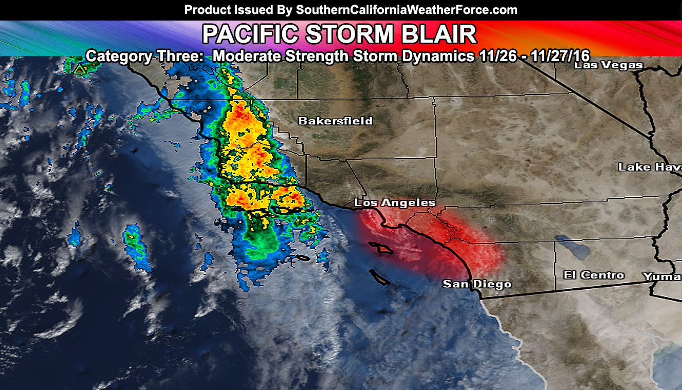
Pacific Storm Blair is a category three system and already moving through the forecast area. My alerts for wind, flooding, snow, and waves is current out on the main site with residual activity sticking around through Sunday. Read on for details.
Pacific Storm Blair has brought one lightning strike way offshore and this is showing the dynamics behind the main front seem to support lightning strikes. The area of most concern for lightning would be the Coast/Valley zones of Los Angeles and Orange County this evening with outer edges of the dynamics in Western San Diego County and the Inland Empire.
A very quick moving front will move through the area today, with residual activity overnight and into Sunday. By early evening it’ll be crossing the Inland Empire areas.
The advisory is not for rainfall amounts … but for cells within the front (possible lightning in spots) … producing brief heavy rainfall that in a short amount of time could lead to urban street flooding … Careful on those roads out there …
One thing to note is that the low level flow is southwest to northeast so if you are on the southwest side of the mountains, you’ll see more than if you are on the due south or west of them through this evening. This means that if you are ikn Orange County … being southwest of the Santa Ana Mountains would help … being North Basin or Coast may not …
Click Here for your frontal zone arrival time estimation …
A frontal zone entering Ventura County right now is surging eastward and with it snow levels of 5,000 – 5,500 FT are going to be with the main swath of heavier precipitation and with those gusty winds will make for blowing snowfall.
The front will hit the Kern Mountains this afternoon and through the SBD/RIV/SD Mountains this evening … with residual light snow showers all night.
Wet snow likely in the Town of Tehachapi with this … but a lot of accumulation is not expected there. Another system hits slightly on Sunday for renewed snow showers.
PMC stands to see a few inches of snowfall with up to an inch on the Gorman Pass.
The LA County Mountains will see anywhere from 2-4″ in the middle elevations and over 6+ inches up in the upper elevations.
The southwest slopes of the upper San Bernardino Mountain rim will see from 5-8″ of snowfall with over 10″+ on the Upper Peaks … and 3-6″ in Big Bear Lake.
Mid elevation Riverside Mountains will see 3-5″ of snowfall and the Palm Springs Aerial Tramway over a foot …
Most of the San Diego Mountain cities will be below the snow-level but upper peak elevations above 5,500 could pick up a couple inches.
Updates will be made to the advisory when Sunday’s numbers become more clear.
NOTE: Members Click Here For Your Snow Level Tables
Wind gusts from 30-50 mph will be likely with this round for the mountain/desert areas
On Sunday, the flow turns from southwest to west-northwest off the eastern slopes of the Kern, San Bernardino, Riverside, and San Diego Mountains and spills into the deserts from there. 50+ mph wind gusts will be likely for areas near the eastern slopes, Barstow forecast area, and Morongo Valley … with advisory level 30-50 mph gusts for the Coachella Valley .. Imperial Valley could see damaging winds on the western side of the county …
On Sunday, expecting a surge in gusty winds for the coastal/basin/valley areas off the ocean behind Pacific Storm Blair.
The winds will die on Monday with offshore Santa Ana Winds developing for the metros …
Two strong fronts will impact the area this weekend … the first one arriving later on Saturday and the other early on Sunday. Both fronts will be capable of strong winds, heavy rain, and a chance of thunderstorms.
Waves with this one offshore and on the coast will be high, on the order of 10 FT in southwest and west facing beaches on Sunday with a strong west to east flow.
Residual showers will move through with the gusty winds on Sunday … Cruella will be pulled inland as the previous article stated in the bolded sentence. Cruella will be put back into the name list and this weekend will just be Pacific Storm Blair.