
Major Pacific Storm NIKITA will remain a Category Five system and is projected to impact Southern California early Tuesday morning, lasting into the day and evening for some metro locations. She’ll bring severe storms capable of damaging winds, mountain snowfall, flooding, and even that real chance of tornadoes. so find out where you stand by reading on …
Before I begin, note this is what is said on the video above so you can play the embedded video for visualizations. Furthermore ALL alerts are to be found under ‘current alerts’ on the main page, with a wide variety from wind, snow, severe storms, flood, ocean, and more that this article does not offer altogether so don’t miss your alerts and you can view them by CLICKING HERE
These alerts in micro-climate form are issued to various Facebook Groups I have outside the main one. Find yours by clicking here.
If it does not say “Liked” LIKE The Page Below and join thousands of informed weather forecast viewers in our region for more of the updates!
Latest satellite images this evening shows a potent storm front showing all the classic signs of a major Pacific Storm. Major Pacific Storm NIKITA is a category five on my one through six scale. The lack of actual Pineapple Express dynamics made it only one number away from being a category six, a once in every 10 year storm. She will finalize as a Upper End Category Five System, a once in every three to five year system.
The member section has all kinds of models and charts for this system so I’ll go ahead an briefly go through them for you.
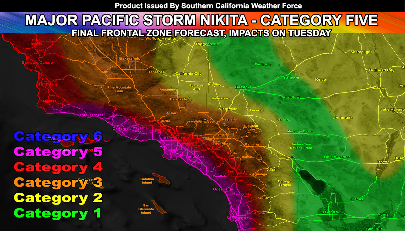
Starting off with the timing of the system. Countdown clocks are available right now in the member section for everyone to view. CLICK HERE TO VIEW IT – Timing of the potent storm front Tuesday morning across the Southland is as follows;
Vandenberg Air Force Base To San Luis Obispo by 2am.
Ventura by 4am.
Los Angeles and Bakersfield by 6am.
Orange County to Lancaster between 6 and 7am.
Western Inland Empire to Hesperia by 7am.
San Diego to Eastern Inland Empire between 7 and 8am.
And The Coachella Valley to Morongo Basin after 9am, developing into the Eastern Deserts around noon.
HATE THE ADS or Love the Forecasts and Want To Support The Work To Help it Stay? Become a premium member and support the service and receive forecast perks as well …
Click Here To Learn More …
Moving onto Flood Risk. Flood risk chart shows moderate flood risk in San Diego due to a fast moving front with little to no lifting north of it so it’ll remain potent for you, but nothing like further north in the high and extreme risk sections across the Inland Empire, Orange County, Los Angeles, Ventura and San Luis Obispo County. Orange, or moderate value is showing up for Lancaster to Bakersfield, which means in addition to the front on the frontal zone times I already said you’ll have the risk of thunderstorms as well.
Snow level charts were updated today and to give you a look what they look like in the member section here is the LA County Mountains chart showing high snow levels to start with lowering to 6,000 FT for the most part on Tuesday. I do not believe they’ll be lower like other agencies are calling for simply because this system is coming in further south, upping the snow level over 5,000 FT with little lowering and upper the severe thunderstorm and instability dynamics in the process.
Snow amount chart shows snowfall at the tail-end of the front and then again with the secondary batch over the day and evening on Tuesday, which I’ll get into very soon. Note the San Diego County Mountains have a lack of snowfall due to the higher snow levels, where maybe a dusting for Mt. Laguna is possible, with nothing accumulating in the metro mountain towns in that range.
The tornado and thunderstorm projection model is showing extremely high severe thunderstorm and even tornado dynamics for along the coast and 10-15 miles inland in the Orange, Los Angeles, Ventura, and Santa Barbara County areas… The severe weather statement issued on the site states that these areas on pending tornado watches, with severe thunderstorm watches extending possibly down into San Diego and into the entire Inland Empire areas. Thunderstorm watches may be needed for the Antelope Valley, High Desert, and Kern County zones for Tuesday as well.
HOW IS CATEGORY CALCULATED HERE? Click Here To Read How
Click Here To Find Your Zone On Facebook For Updates Now and In The Future
Click Here To Find Me On TWITTER.
The severe weather dynamics fall into increase instability, low level wind backing out of the southeast, and a rare sub 1000mb surface low just west-northwest of the area, which would be responsible for the low level shearing and tornadoes that will form.
The secondary impulse I talked about in previous articles will move through over the day on Tuesday and into some of the evening. This impulse will impact Santa Barbara to San Diego, with LA/OC in the center of the dynamics, stretching east ot the Inland Empire, delivering yet another round of thunderstorms, some capable of producing large waterspouts and or over-land tornadoes in the coastal/basin areas.
Major Pacific Storm NIKITA is poised to be a category five system and impact Tuesday morning bringing in a multi-tude of weather events across various areas of Southern California so for more updates stay tuned to Southern California Weather Force.com