
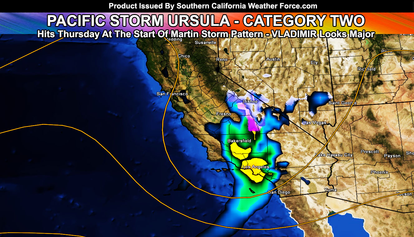
At The Beginning of January 2019, the January 2019 forecast was released and stated we would return into the storm pattern by end month into February. Well here we are right on time and Pacific Storm Ursula will start at a nominal category two system out of the 1-6 scale by Thursday with the chance of Vladimir being a Major Pacific Storm (Category four or higher) by the weekend. Read on more as we start the Martin Storm Pattern once again.
Pacific Storm URSULA is the next on the list. This system is rather normal and happens many times a year on the scale. Ursula will come into Vandenberg to San Luis Obispo zones early Thursday morning with a fast-moving cold front that will sweep Los Angeles, Orange, San Diego, and the Inland Empire through the day. There are some indications of moderate flood risk for a Flood Advisory across those same zones, with lower risks in the High Desert. Given the angle of the system and some low-level drying. Lancaster will see a bit more rain than say the Victor Valley where some drying in the low levels would bring far less precipitation for you.
The snow levels will range from 6,500 to 7,000 FT.. so again this is a mid-warm type system. The same could be said for Vladimir on Saturday with stronger warm air advection in the beginning but after the cold front passes we could see levels down below 5,000 FT and maybe lower than that. Thursday does not look like major mountain community snow producer at the moment, however Saturday is being watched carefully.
Upper divergence, instability, and lift with the system will be possible to bring a chance of thunderstorms with it across the entire metro zones, including deep-layer moisture making it to Imperial County through the San Diego Mountains for some precipitation there as well.
Major Pacific Storm Vladimir is next for this weekend, targeting around Saturday into Sunday. This one will be the one to watch out of the two as he does have the risk of major flooding and severe weather.
There is a chance that February 2019 will yield 4 to 6″ of rainfall for Los Angeles, which would make the preliminary numbers above average.
Premium members will be able to follow the progress of the developing pattern daily starting NOW …
End
NOTE: Premium members. If you are signed up, your login is your e-mail address and the username and password as the password. You can change the password
Ongoing Ad – The Southern California Weather Force has a member section with LIVE UPDATES FOR EVENTS and rain, wind, thunder, tornado etc models that are personally updated by me with each Santa Ana Wind or storm event. You also can get e-mailed alerts via a slew of micro-climates. Check the member section for details on how you can support this service.. along with getting service in return… Click Here To Join or Upgrade Via The Member Section
Please remember if upgrading to CANCEL YOUR PAYPAL PAYMENTS. Login and cancel the reoccurring payments.
The Southern California Weather Force has different Facebook groups that you can ask for notifications from in order to get the latest posts affecting those regions. If that area is talked about in an article, alert, and such .. it’ll be posted there and you can be notified.
Comments are usually DISABLED as we do like to keep this as a piece of information giving group and replies from others in the notification may annoy some.
Find your micro-climate group here – https://www.southerncaliforniaweatherforce.com/scwf-weather-alert-facebook-groups-by-region/
SOUTHERN CALIFORNIA ONLY: if it does not say “Liked” LIKE The Page Below and join thousands of informed weather forecast viewers in our region for more of the updates! noticeable
BEHIND THE SCENES FORECASTS/UPDATE PAGE: if it does not say “Liked” LIKE The Page Below and join thousands of informed weather forecast viewers in our region for more of the updates! noticeable