February 3, 2019 at 8:36 pm

INITIAL DETAILS: Pacific Storm Warren Begins Monday and lasts through Tuesday Night

by
1.1K+Shares

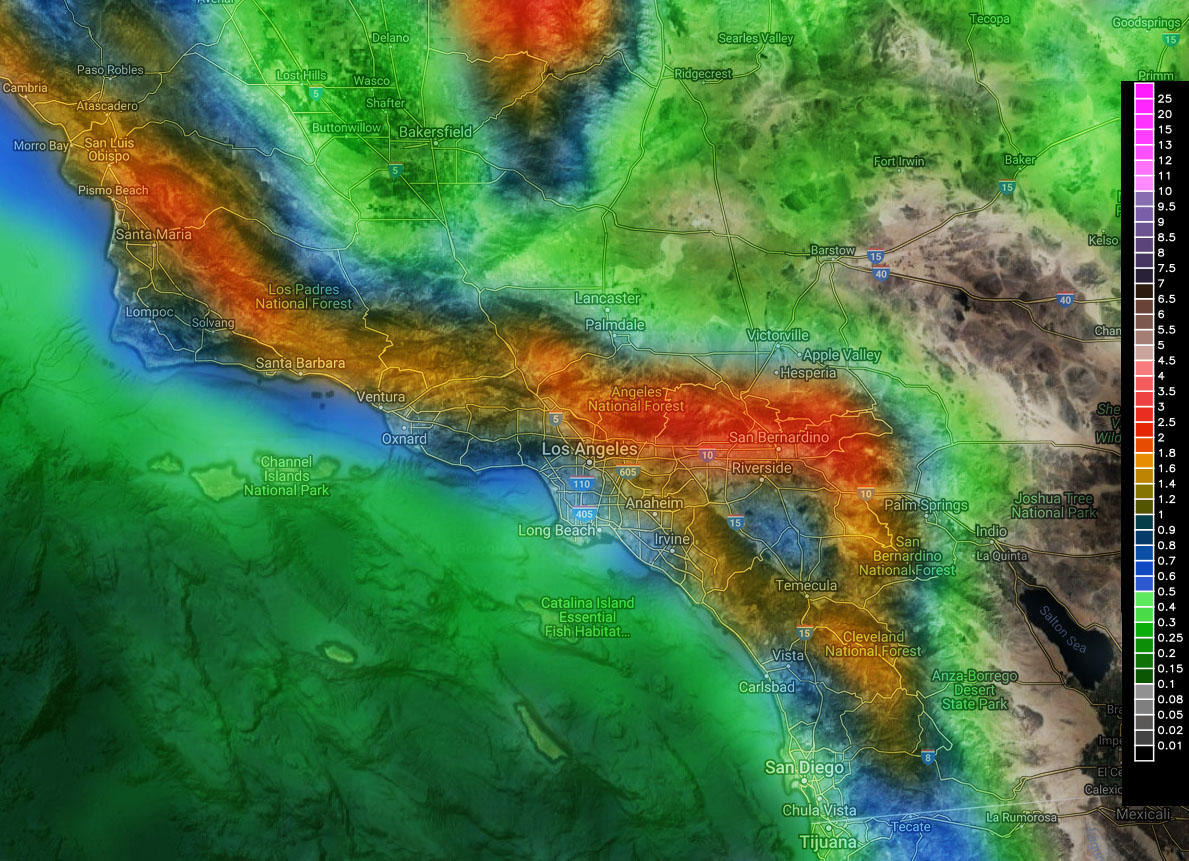
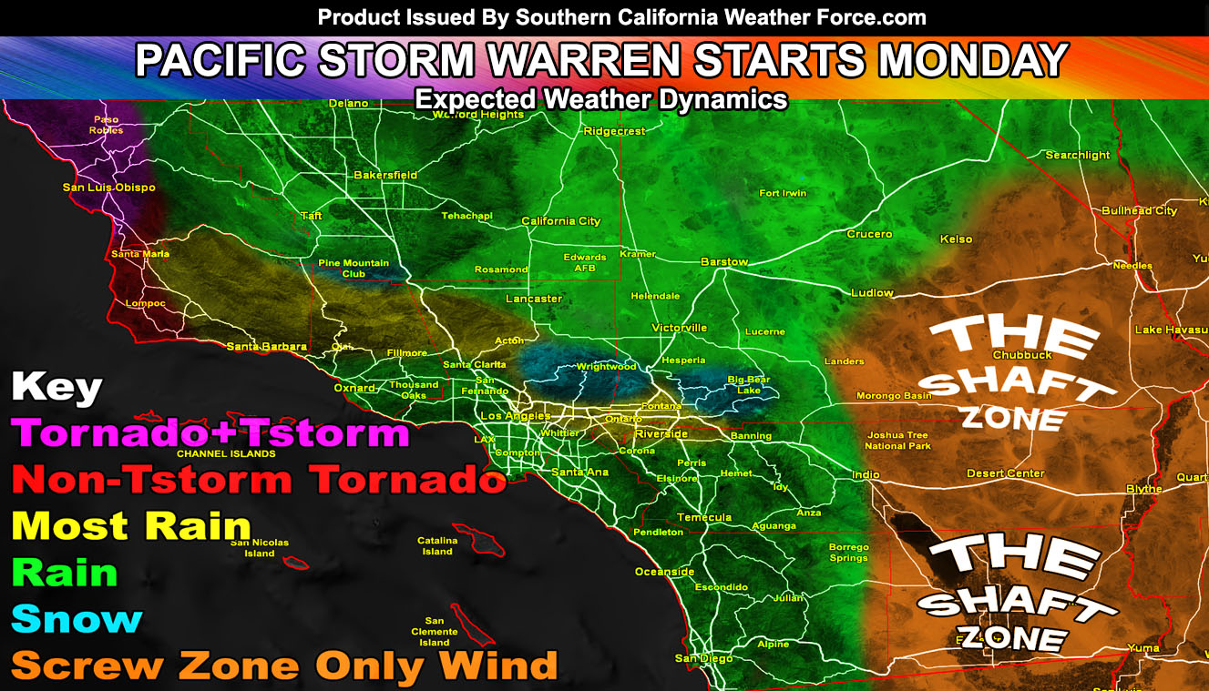
Pacific Storm Warren will enter the forecast area on Monday morning and sweep the first front through over the day.  Multiple frontal zones will move across like ripples of waves on a pond through then and Tuesday night, each getting colder.  Read on for initial details …

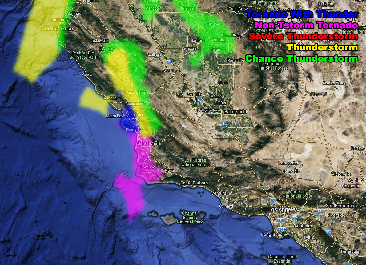
Starting Warren off as a category two system. The system will affect San Luis Obispo and Vandeberg by morning. I’ve issued a Tornado Advisory for San Luis Obispo for thunderstorms capable of producing a tornado and also Vandenberg/Lompoc region for non-thunderstorm producing waterspouts to a weak tornado. Given what happened last night it looks nearly the same.  Read as followed;
A cold-front will make its way into the San Luis Obispo zones after 3am Monday morning.  This bring strong lifting along the front and with added instability will be enough for thunderstorms to form.  However, Thunderstorms will be reserved for San Luis Obispo County.  The NEW SCWF Tornado and Thunderstorm Forecast model now has a new value for non-thunderstorm producing waterspouts to small tornadoes.  This value is ‘magenta’.  The ‘Thunderstorm’ value with tornado dynamics is a darker blue value on the model.  The thunderstorm colors remain the same.  You can see that below.  Based off some weak shear in the area, non-thunderstorm and thunderstorm producing weak tornadoes and waterspouts will be likely between 3am and 8am Monday morning.  Thunderstorm dynamics should not reach the Vandenberg/Lompoc regions, however non-thunderstorm producing tornado dynamics will.  Thus.. i have put the area under a Tornado Advisory for both, using this wording as your forecast to know who would see what.
Link – https://www.southerncaliforniaweatherforce.com/2019/02/03/tornado-advisory/

I do have a flood advisory for Santa Barbara based on my moderate risk flood value on my flood risk model, which is the main image you see and goes through the entire day and evening on Monday.  Read as followed; A frontal zone will come in on Monday.  For a brief period of time the SCWF Flood Risk model shows moderate risk and this is enough for a rainfall rate conducive of a Flood Advisory.  Expecting an inch of rainfall with this front, most of it falling Monday morning with this round.
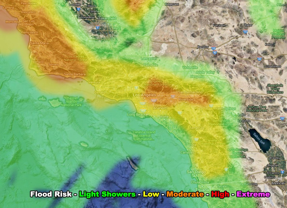
Link – https://www.southerncaliforniaweatherforce.com/2019/02/03/flood-advisory-21/
 
Use Flood Risk Model Below Article:  You can also note the orange or moderate (advisory level) risk for Los Angeles, The San Gabriel Valley, Ontario, Fontana, San Bernardino, and Yucaipa. This is due to some southerly flow that will enhance the rainfall south of the local mountains. This would be a flood advisory as well and I’ll look into it in the morning to issue one. This happens later in the day.
 
Snow levels will be around 6,000 – 6,500 FT for most of the day. Big Bear will pick up a couple more inches and by Wednesday at midnight probably 6-8″ in total east 8-12″ west end . The RIM like Snow Valley would pick up more of course at 8-12″ due to favorable upsloping there on the southern end of the mountains while Big Bear is stuck in the way back where some deeper-layer moisture will be hard to come by at times.
 
Use Wind Model Below Article: Winds with this event will not be ‘as strong’ as the last time but with the frontal zone on Monday we could squeeze some 30-40 mph gusts in the metro and desert areas, with the mountains seeing 50+ mph at times.
 
On Tuesday the colder frontal zones come in.  The snow level will lower through 4,000 FT and make a run for even lower on Tuesday night.  I will reserve to wait on who gets what until 12 hours before it is due to arrive due to errors that can compromise a forecast.  I do know however the San Diego County Mountains would need a Winter Weather Advisory on Tuesday’s frontal zones.
 
That is it for now, use the model images below for this event for MONDAY, February 4, 2019

ripples

SCWF Flood Risk model 2-4-2019
SCWF Tornado/Tstorm Risk model Monday Morning
SCWF Precipitation Model 2-4-2019
SCWF Wind Gust Model 2-4-2019

End


NOTE:  Premium members.  If you are signed up, your login is your e-mail address and the username and password as the password.  You can change the password

Ongoing Ad  – The Southern California Weather Force has a member section with LIVE UPDATES FOR EVENTS and rain, wind, thunder, tornado etc models that are personally updated by me with each Santa Ana Wind or storm event.  You also can get e-mailed alerts via a slew of micro-climates.  Check the member section for details on how you can support this service.. along with getting service in return…  Click Here To Join or Upgrade Via The Member Section
Please remember if upgrading to CANCEL YOUR PAYPAL PAYMENTS. Login and cancel the reoccurring payments.

The Southern California Weather Force has different Facebook groups that you can ask for notifications from in order to get the latest posts affecting those regions. If that area is talked about in an article, alert, and such .. it’ll be posted there and you can be notified.

Comments are usually DISABLED as we do like to keep this as an information giving group and replies from others in the notification may annoy some.

Find your micro-climate group here – https://www.southerncaliforniaweatherforce.com/scwf-weather-alert-facebook-groups-by-region/

EMAIL ALERTS?  Many micro-climate zones to choose from to get custom alerts from thunderstorm, wind, flood, surf, heat, cold, storm, and much more with the premium e-mail alert system, the most advanced zone alert system in Southern California – Click Here To Join!

SOUTHERN CALIFORNIA ONLY:  if it does not say “Liked”  LIKE The Page Below and join thousands of informed weather forecast viewers in our region for more of the updates! noticeable

BEHIND THE SCENES FORECASTS/UPDATE PAGE:  if it does not say “Liked”  LIKE The Page Below and join thousands of informed weather forecast viewers in our region for more of the updates! noticeable

VISIT THE MEMBER SECTION FOR 2018-2019 SEASON  – SIGN-UP OR READ ABOUT IT HERE AND GET ADVANCE UPDATES DURING WEATHER EVENTS THROUGH THE ADVANCED EMAIL ALERT SYSTEM FOR MICRO-CLIMATE ALERTS ISSUED HERE!


Comments are closed.

wp_footer();