
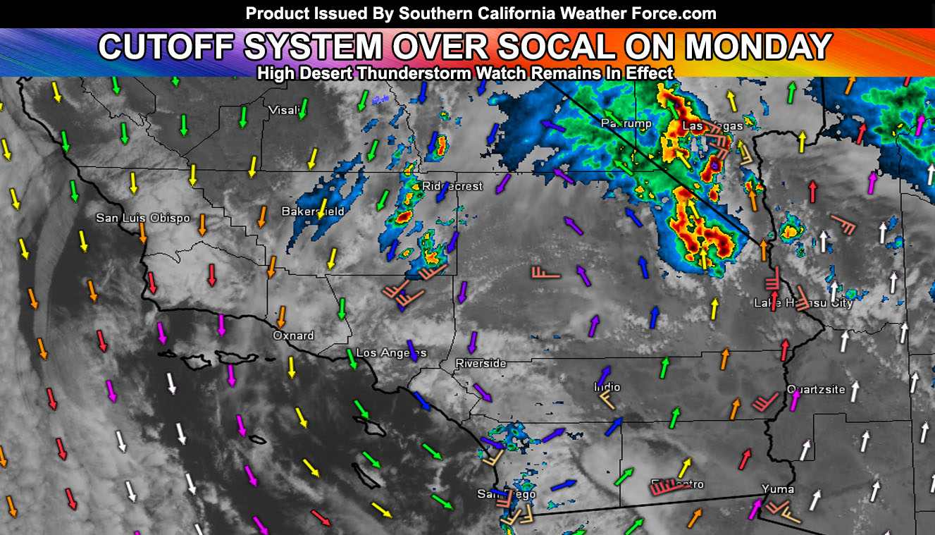
Latest radar and upper-level wind fields show the cutoff system directly over Big Bear Lake at the moment, with storms on the east side coming out of the south into Las Vegas, right on schedule, and the backside popping activity in the Kern Deserts, north to Inyo County along Highway 395, which will filter southward toward the Metro High Desert zones later today so for your area’s forecast, read on for details.
Yesterday’s update showed that most of the metro zones would see just showers, in the green colored areas. In the evening and overnight, thunderstorms popped offshore but never made it to the land so this was on track. We did get thunderstorms south and north of Downtown Ventura and Santa Barbara, whereas the northerly storms were within the yellow shading zones from Ojai/Fillmore so this was on track once more.
Thunderstorms are were ongoing in the Kern County zones within the Thunderstorm Watch issued yesterday for this event there. Thunderstorms are also were ongoing in the San Bernardino Deserts within the thunderstorm shading zones in the image from yesterday (Click Here To Read That Article)
As for the rest of today, the back-side of the storm system would switch the flow to northwest going southeast this afternoon and evening. This would bring upper divergence to the Lancaster zones, southeast through the Cajon Pass/Wrightwood areas and further southeast into Fontana/Yucaipa/Redlands/Moreno Valley, and the Banning Zones. The entire Victor Valley should light up today …
A Thunderstorm Watch was issued this morning for the rest of today for the entire High Desert zones, into some of the San Bernardino/Los Angeles Mountain regions, including the Cajon Pass too. It reads; As per the article yesterday (Click Here To Read That), Thunderstorm wording was in the entire High Desert region for this system as you would not be in a dry slot like the LA/OC/IE/SD Metros would be in. Thunderstorms are ongoing in parts of the watch area, however, this watch is for an increase in population zones receiving a direct hit with thunderstorms today, from this morning, increasing over the afternoon, and ending from west to east through the later evening hours.
Thunderstorms will eventually move on the backside of the cutoff system from northwest to southeast and this will impact along the eastern slopes of the Kern County Mountains and push into the adjacent desert areas of LA/Kern County, including Ridgecrest, Edwards AFB, and the Antelope Valley zones. Convergence, later on, would ignite the El Mirage Convergence Zone along and west of I-15 over KVCV Airport Adelanto.
This is similar to the ‘monsoon season location’ where that zone goes up and the storms sometimes blow eastward into the populated Victor Valley zones, north to Barstow, including the Cajon Pass areas. Expecting over 90% of this watch to produce lightning through today, including the 29 Palms areas on or near Highway 62, east to the CO River Valley needles areas.
If you are traveling to and from Vegas today, expect widespread thunderstorms and gusty winds. Thunderstorms today could contain some hail and gusty winds… with frequent lightning likely. When you hear the thunder, go indoors… Activity in the High Desert will cease tonight …
NOTE: A very affordable e-mail alert system that only gives you SCWF weather alerts in YOUR micro-climate area SUCH AS THE THUNDERSTORM WATCHES THIS MORNING AND YESTERDAY BEFORE THE ARTICLE WENT PUBLIC. Also, you can ask the weather office a question at any time if you get that add-on.
Click here to join
METROS: As for the metros south and west of the mountains, onshore flow will keep off and on showers through Tuesday …
As for the California Fault Stress Model program, a double 4.0 hit Nevada yesterday and a double 4.0 hit Northern California just after midnight this morning with a near 4.0 a Bishop on Highway 395 today, on track to that big peak in pressure detected on April 24th so this is remaining residual from it. To follow the project I have for Fault Stress, Click here at the California Fault Stress Model
The longer range pattern still calls for continued activity, off and on, through May 3rd or 4th through the 10th. I’ll be back with updates.
For The Main Weather Facebook Page Click Here and Join.
End Article
OPTIONAL: Southern California Weather Force main page now has models, agendas, the alert map, and other things updated during storm events. You can bookmark the main site and check back during an event for the latest updates.
Click here to view the main page
EMAIL ALERTS AND ASK THE WEATHER OFFICE A QUESTION: It pays for itself in one storm system. A very affordable e-mail alert system that only gives you SCWF weather alerts in YOUR micro-climate area. Also, you can ask the weather office a question at any time if you get that add-on.
Click here to join
MICRO-CLIMATE ALERT FACEBOOK GROUPS: Find yours today!
Click here to join
FACEBOOK PAGES TO JOIN!
SOUTHERN CALIFORNIA WEATHER FORCE MAIN: if it does not say “Liked” LIKE The Page Below and join thousands of informed weather forecast viewers in our region for more of the updates! noticeable
BEHIND THE SCENES FORECASTS/UPDATE PAGE: if it does not say “Liked” LIKE The Page Below and join thousands of informed weather forecast viewers in our region for more of the updates! noticeable
FOR THE CALIFORNIA FAULT STRESS MODEL PAGE: if it does not say “Liked” LIKE The Page Below and join the official page to the California Fault Stress Model