
Well here we are. On the article back on November 29th I said another cold system will hit before the month of December was to be over and such a system will be coming in Christmas Night, mainly Thursday. This is officially a mountain pass affecting system, including snow in the High Desert again along with rain elsewhere so read on for official details …
Join Southern California Weather Force main Facebook Page for future updates!
EMAIL ALERTS: Grab a FREE-TRIAL lasting till December 31st to get these article updates and micro-climate alerts on zones YOU set in your control panel
CLICK HERE FOR THE TRIAL
Christmas Weekend to Christmas I am very very busy with friends and family. There was ZERO need to update a thing for this rain we are having. I said in the last article back on the 16th (Click Here) and I quote.., “However, by later Sunday we will see the start of what will be a very active storm pattern in Southern California that will last from the 22nd of December and could very well last with rain in the forecast for over a week through to New Years Day. This is a very prolonged period of rain chances. Since we are talking about the Christmas period, the focus will be on there. I do not see anything to stop storm chances on Christmas Eve through Christmas Day. It is a very active pattern and numbers this far out are very wild. One of these systems will have arctic air entrained into it and we will be looking at mountain pass closing snow-levels and amounts for the Gorman/Tehachapi/Cajon Pass areas.”
You had your heads up for Sunday so no complaining …
As for Christmas Eve and most of Christmas Day. Fully expecting a Pacific Northwest type of feel where off and on showers will be the real story and there wouldn’t be a solid front to predict off of.
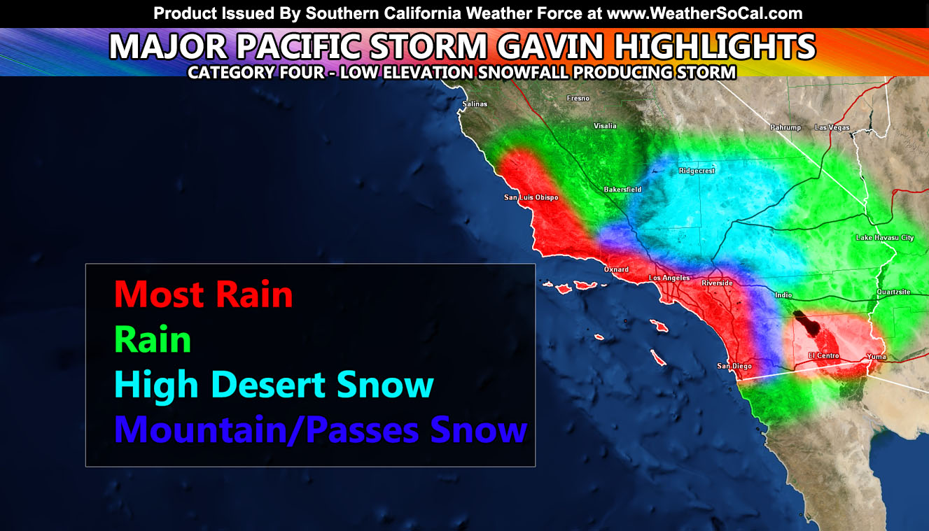
Winter Storm Warnings will be needed for the High Desert and all mountain/pass locations, including the San Diego County Mountains by at least tomorrow for Christmas LATE night and mostly on Thursday but this is your heads up. SCWF grids from Thanksgiving’s storm system were updated to give a low elevation snowfall model and it is going to be used for this system. This is Major Pacific Storm Gavin and I’m assigning it a category four out of six so it is a strong system. The system will also need coast/valley/basin flood watches as it will have more rain in flood prone zones than today’s system.
Micro-climate alerts will be issued by Tuesday afternoon and those will have a lot more details… then an article about them releasing tomorrow, early evening.
There are indications of a shutdown in early January with storms missing to the northeast once again like what is happening now with the Santa Ana Conditions. 9-13″ of rain is still in my forecast for Los Angeles for the season ending May so while we do have these storm patterns, they will be far in-between and not as frequent. January is also looking very cold at times, colder than this month thus far.
So to recap:
- Heavy rain for the metros.
- High Desert Snow Again Like Thanksgiving.
- Mountain Pass Closing System.
- Imperial Valley Heavy Rainfall.
- Happening late Christmas night but mostly the 26th (Thursday).
- Lead-time of forecast (1 month, another record for long range.
As always, stay tuned to official forecasts from Southern California Weather Force for updates …
NOTE: ALL Articles AND Videos posted on Southern California Weather Force main Facebook Page are charity events. Anyone sharing will be entered into a list and one person will be randomly selected to get cash for causes. This started on in October 2019 and SCWF has donated $1883.24 to date of this article and counting. … So share away.. the more shares on Facebook, the more help can be done for the community and it costs you nothing just like a lottery ticket. October 2019’s winner was Jessica J Dominguez, and she has claimed the prize. Are you next? – Check the latest amount to win by CLICKING HERE – Remember… that number is going to climb before the contest closes!
MICRO-CLIMATE ALERT FACEBOOK GROUPS: Find yours today!
Click here to join
For The Main Weather Facebook Page Click Here and Join.
End Article
FACEBOOK PAGES TO JOIN!
SOUTHERN CALIFORNIA WEATHER FORCE MAIN: Southern California Weather Force Office Main Page
BEHIND THE SCENES FORECASTS/UPDATE PAGE: Southern California Weather Force Meteorologist Page
FOR THE CALIFORNIA FAULT STRESS MODEL PAGE: For SCWF official updates to the California Fault Stress Model and more!
“PONDER THIS” SCIENCE ADVENTURE SHOW: A science adventure show developed here at Southern California Weather Force that is a fun ride! It is NOT active during the weather event season.
INSTAGRAM AND TWITTER ACCOUNTS TO JOIN!
Instagram – https://www.instagram.com/socalweatherforce/
Twitter – https://twitter.com/SCweatherforce