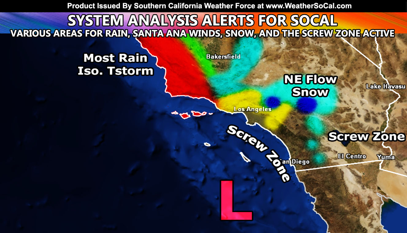
Pacific Storm Hercules will fail to affect half the forecast area and thus the name will be recycled for the next storm system use. This Pacific System will slide southwest of the forecast area and bring snow to the Mountain and High Desert regions along with heavy rain in SLO/SBA County, and Santa Ana Winds in the prone areas. This very detailed forecast will outline just how SCWF operates on a final forecast and there are FOUR alerts issued over the micro-climate alert system so find where you are today and enjoy the NGEN Models (Next-Gen) …
Join Southern California Weather Force main Facebook Page for future updates!
MICRO-CLIMATE ALERT FACEBOOK GROUPS: Find yours today!
Click here to join
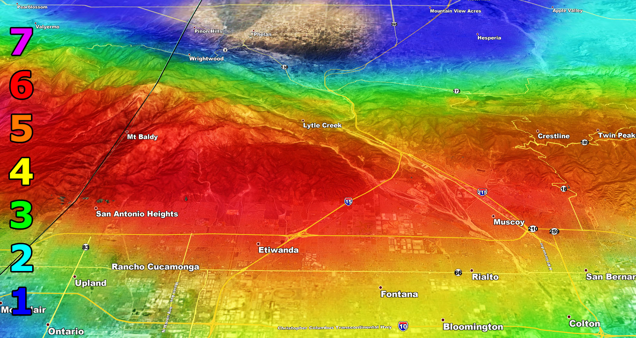
First we get the winter alerts out. SCWF Winter Storm Warning and Winter Weather Advisory has been issued for various sections of the Metro High Desert (Victor and Lucerne Valley) … Morongo Basin … Wrightwood … San Bernardino County Mountains …Riverside Mountains (Tramway) … It reads – A strong pacific system will miss the forecast area well to the southwest. However, the width of the system is going to be the kicker here and the upper divergent section of the storm (lift) will be over the San Bernardino Desert around Ludlow by Monday morning. This will bring a backing northeast flow into the system and with the moisture in place, it’ll squeeze every bit of moisture it has once the orographic lifting hits the north/northeast/east side of the LA/SBD/RIV Mountain ranges. This is where the snowfall forecast is coming in and why.
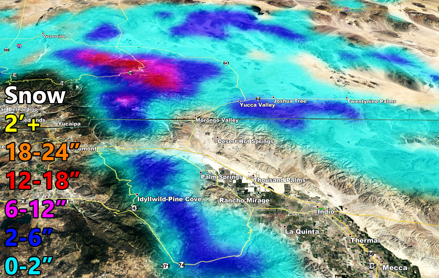
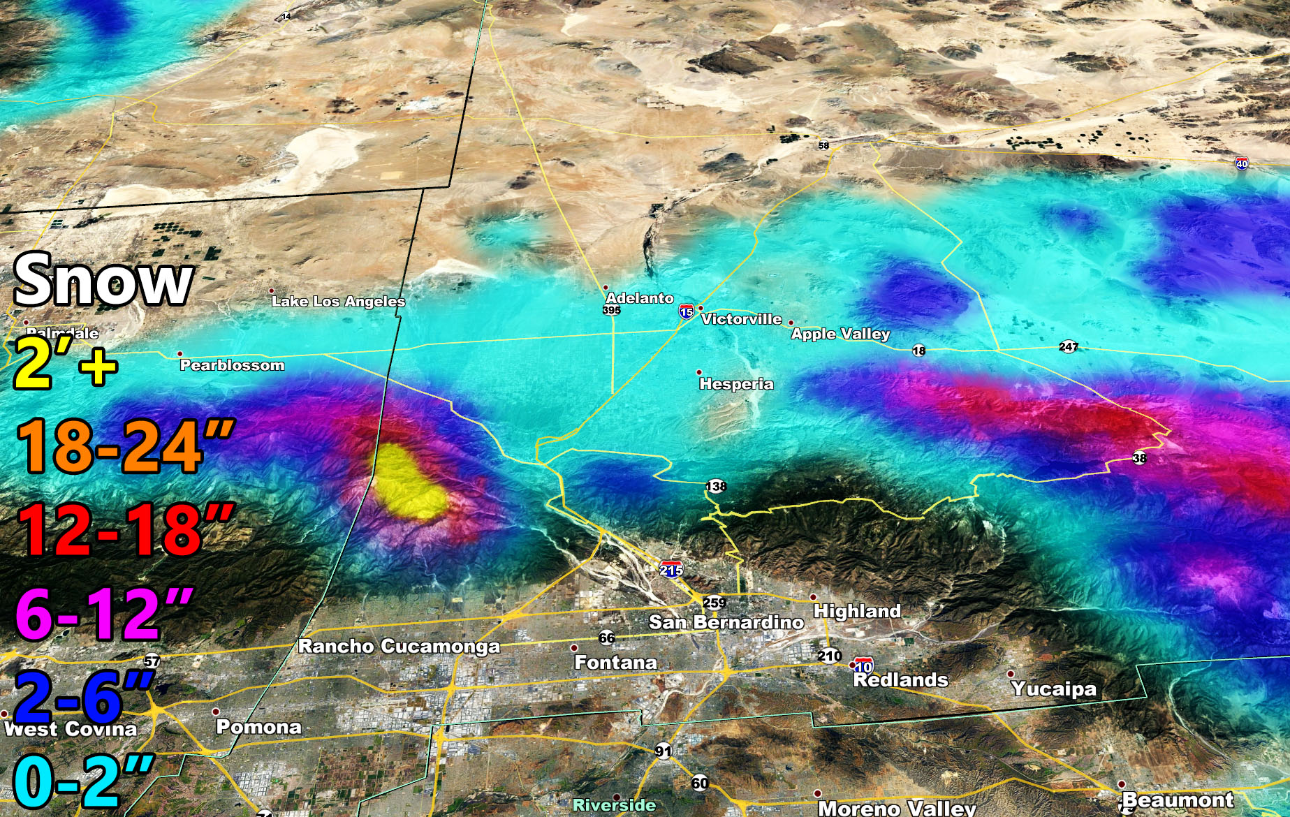
Now for areas … The SCWF Winter Storm Warning is for the prolonged period of snow from Monday morning through Tuesday morning. This could be an 18 hour snowfall and even if gentle at times… the high snowfall ratios due to the drier air mixing in.. will make snowfall pile up. For the Wrightwood areas you will see a suitable amount of snowfall, maps are provided. Big Bear you will see a good amount in town and the eastern end of the mountain/city while the dam (west end) sees a dusting. Again this is going to show what SCWF models are capable of in a short distance on the mountains.
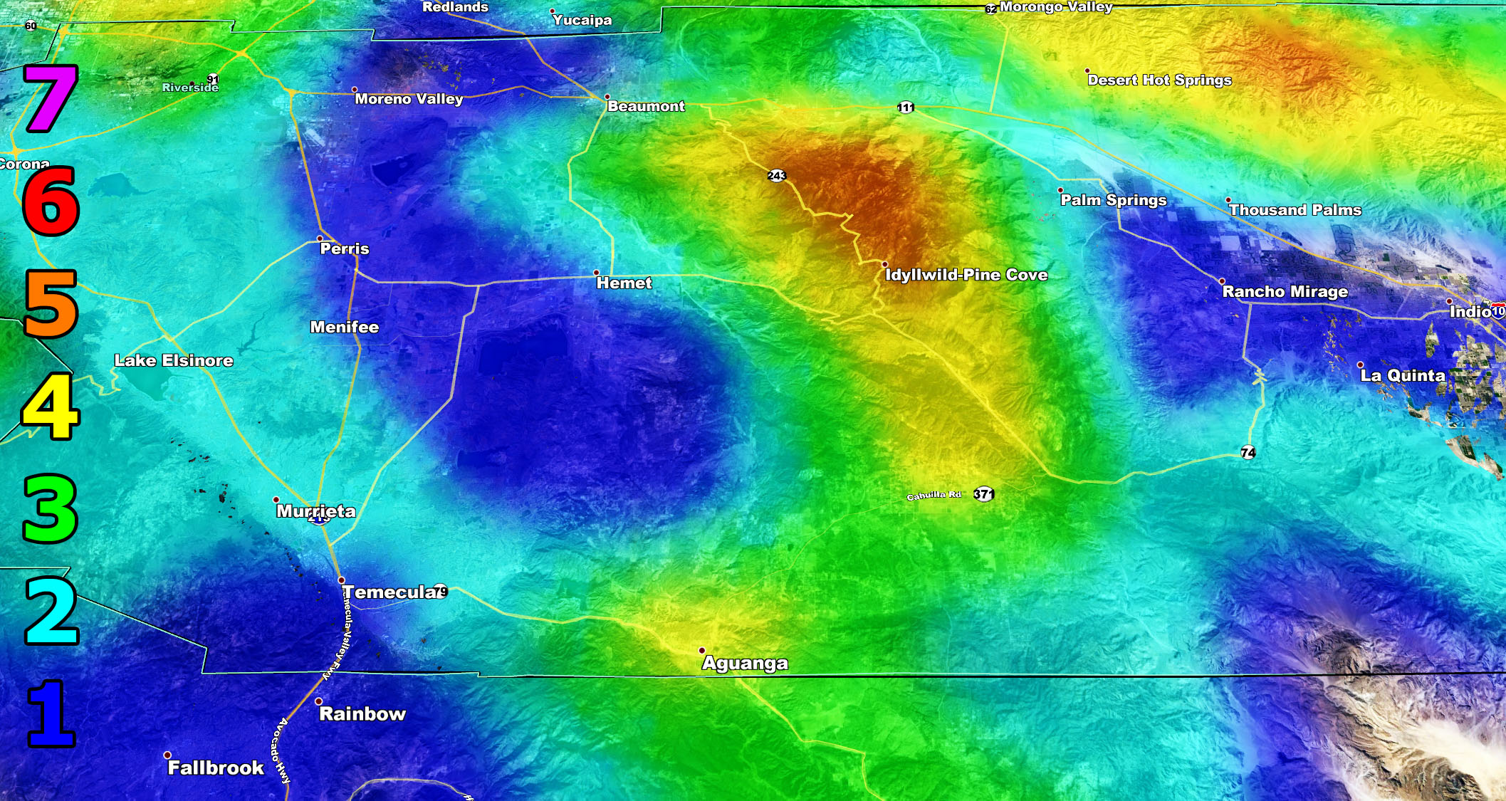
The Winter Weather Advisory is for ANY falling snowfall and this is for the Metro High Desert, including the Cajon Pass to Morongo Basin and even Crestline for any leakage over the mountain. Yucca Valley will see the most from the advisory area. The east end of the Riverside Mountains will catch the moisture and thus a good 2-6″ is possible in the Palm Springs Aerial Tramway area.
BIG BEAR TRAVEL PLANS. If you are traveling to and from Big Bear, take the 18. Do not attempt the 38 into the SCWF Winter Storm Warning zone where snow will be the heaviest on the Eastern Range. Those traveling up from the High Desert, do not attempt Lucerne to Big Bear on Highway 18. Take Silverwood through to the 18 and go around that way.
CAJON PASS: I do not see a reason to close the pass with this system. To and from Vegas be cautious in the 0-2″ area but overall not a big deal.
Forecast amounts could go a bit lower or so but the general idea is in this alert write-up on where the snow will catch and where it will not.
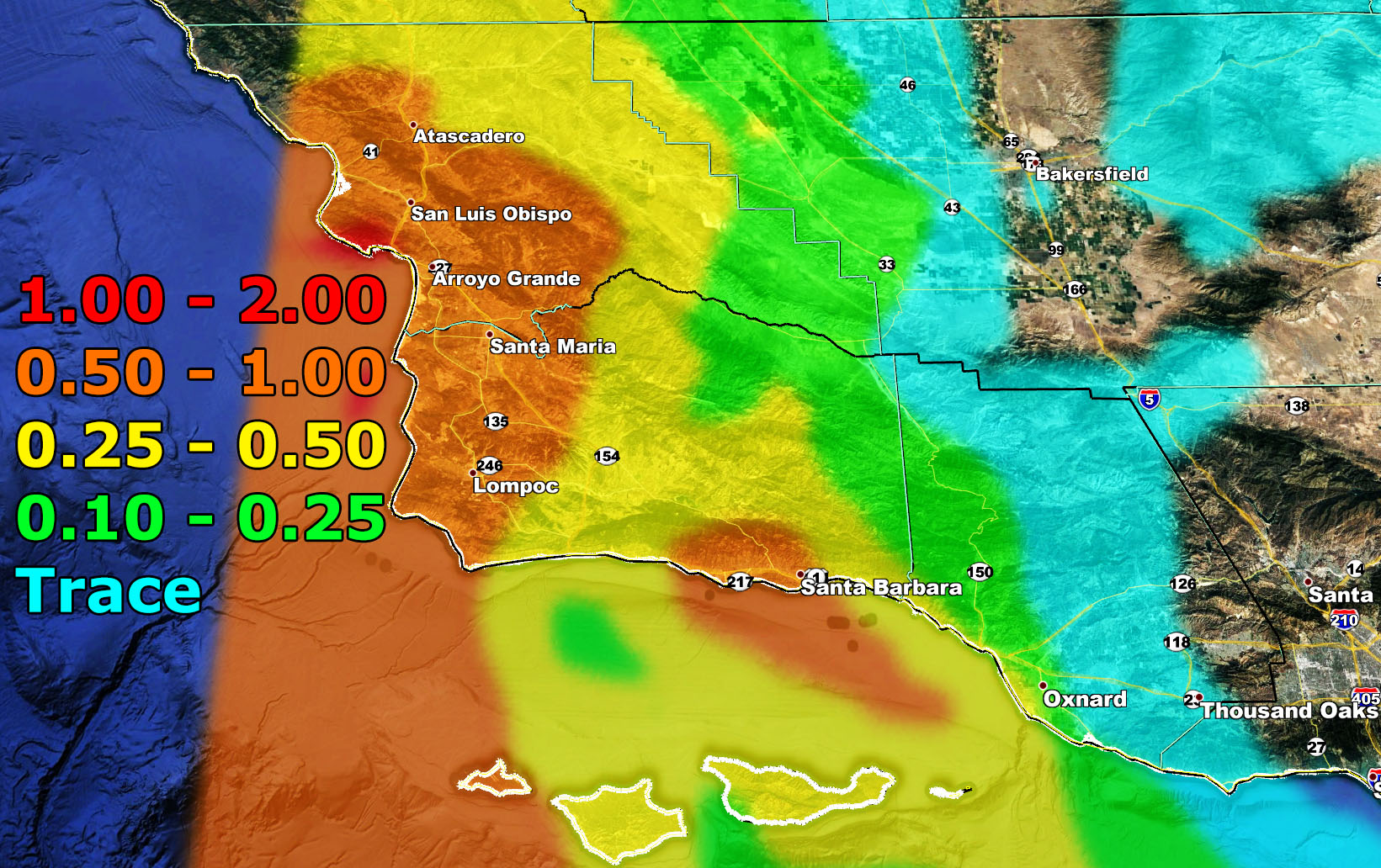
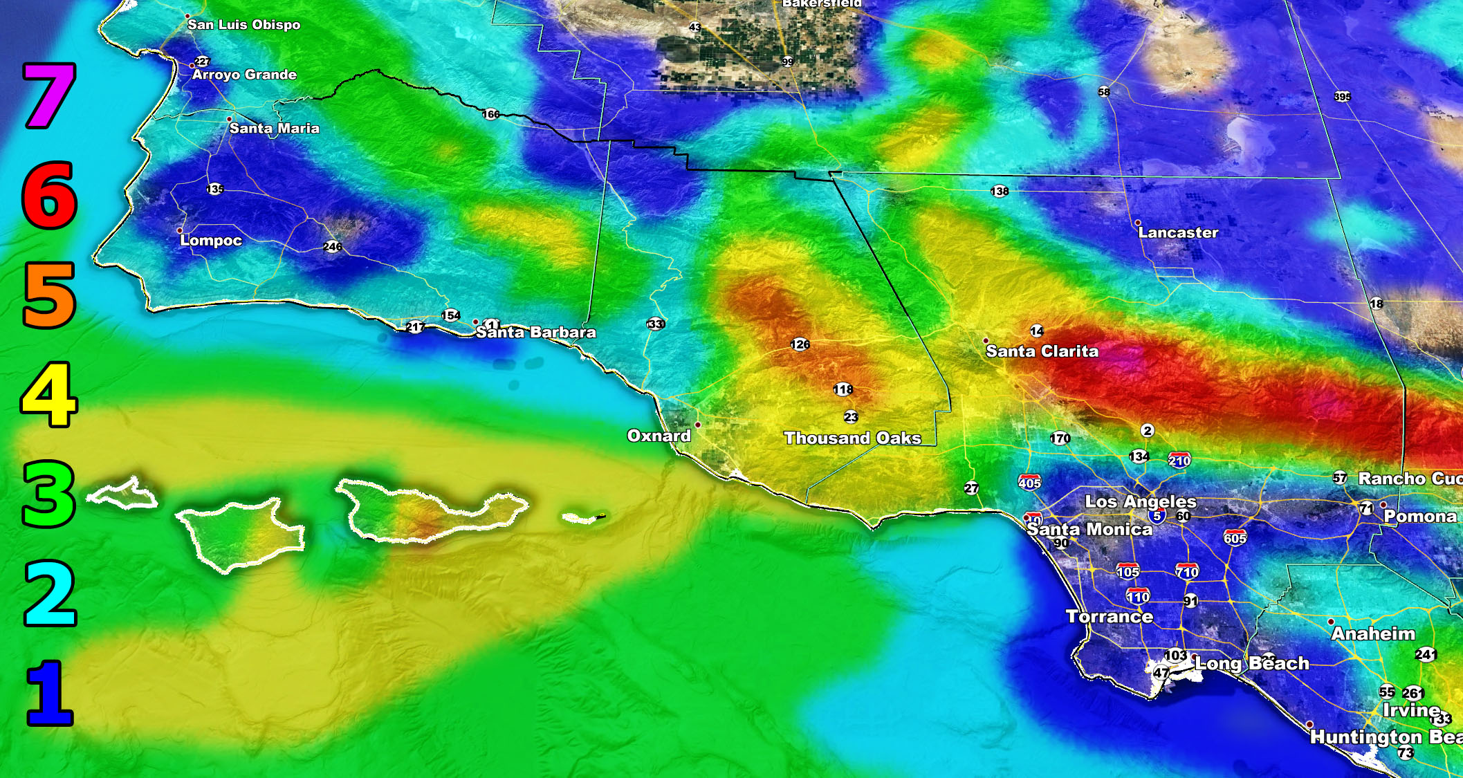
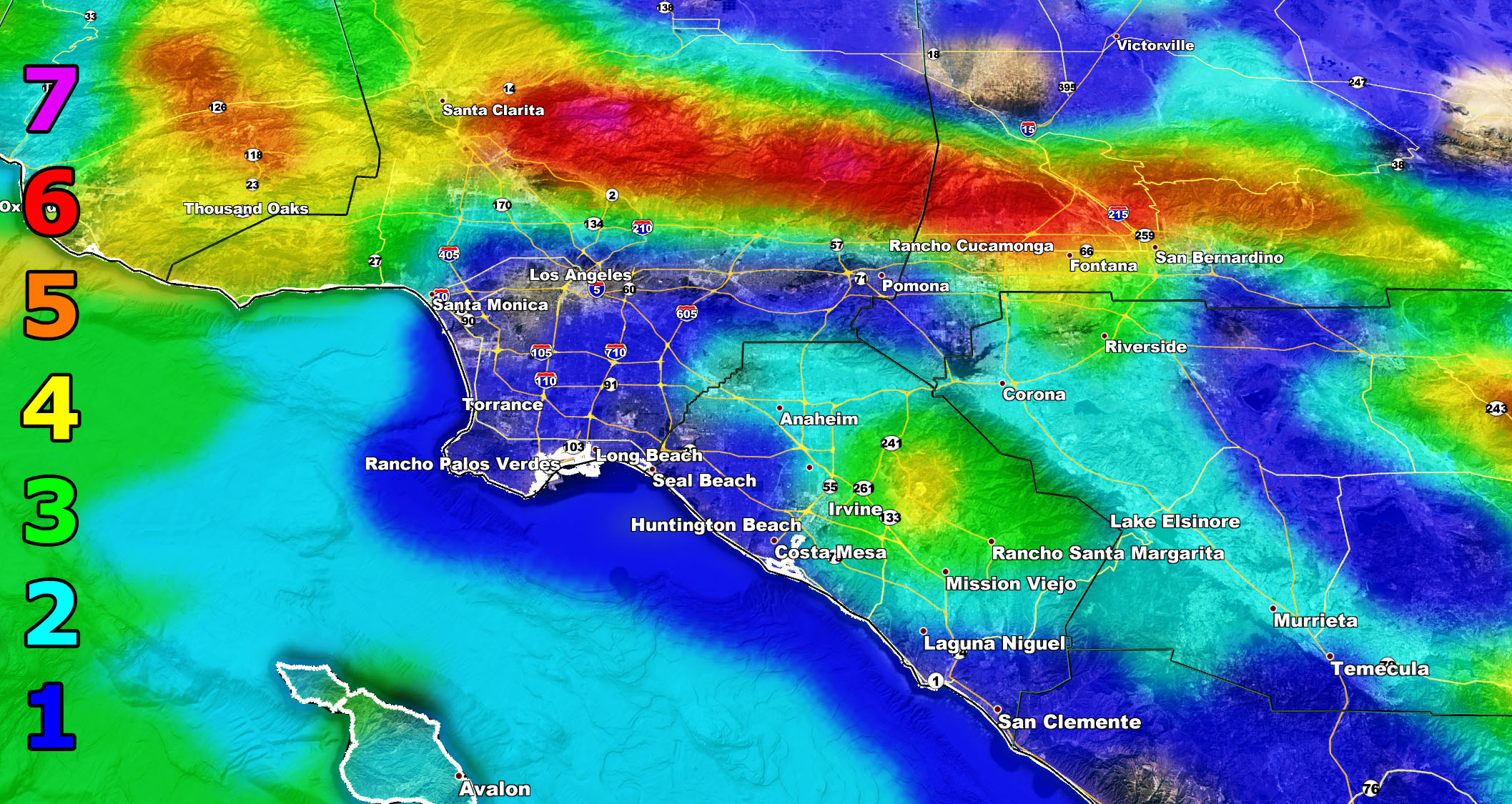
The SCWF Special Weather Statement is in effect for Santa Barbara and San Luis Obispo County … It reads – A weather system is expected to come into the forecast area and hit the region starting tonight and going into just after 8am on Monday. This quick hitting system will bring a round of rainfall to the statement area and also isolated thunderstorm risks for the Western SLO/SBA County areas.
It is not expected to bring high winds or severe thunderstorm dynamics. There will be a low-moderate risk of flooding along the SBA/SLO Coast with this one but nothing too bad – Use the image below for the SCWF Rainfall Forecast Model to find out your area –
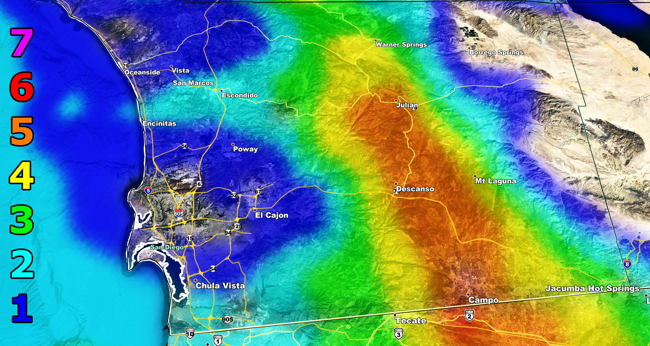
And Finally the Santa Ana Wind Advisory is in effect for Ventura Coast/Basin … SCV/SFV … San Gabriel Valley along and north of the 210 … Channel Islands … Orange County Basinand Santa Ana Mountains … I-15 Corridor from Corona to Cajon Pass … Riverside Mountains Idy/Anza/Aguanga … San Diego Mountains … Eastern Imperial County Glamis/Winterhaven … Needles forecast area … it reads – A strong storm missing to our west will generate a surface low southwest in the ocean. This surface low will bring strong offshore gradients into the area and Santa Ana Winds will begin on Monday across the region, going through Monday night, and ending over the day on Tuesday. The new style here at SCWF is to not talk about it much, but show you the SCWF wind model with the Martin Wind Gust Scale and those images are below. They are valid Monday through Tuesday, maximizing overnight on Monday.
Trucker Forecast: (Intensity 5 and higher locations for roll-over risks) – Bottom of the Cajon Pass along the 210 – Along the 210 through Tujunga into Santa Clarita – Along the 126 between Fillmore and Santa Paula – I-8 Corridor through the SD Mountains –
Martin Wind Gust Intensity Scale –
8. Extensive widespread damage.
7. Trees are broken or uprooted, building damage is considerable. – High Profile Vehicle Roll-Over CERTAIN.
6. SOME Trees are broken or uprooted, building damage is possible. – High Profile Vehicle Roll-Over Likely, Do NOT recommend Traveling in this zone
5. Slight damage occurs to buildings, shingles are blown off of roofs. HIGH WIND WARNING CRITERIA – High Profile Vehicle Roll-Over Possible if weight is not corrected.
4. Twigs and small branches are broken from trees, walking is difficult.
3. Large trees sway, becoming difficult to walk. POWER SHUTDOWN THRESHOLD WIND ADVISORY CRITERIA
2. Large tree branches move, telephone wires begin to “whistle”, umbrellas are difficult to keep under control.
1. Small trees sway.
For the ones I didn’t mention, like San Diego, Bakersfield, Ridgecrest, Lancaster, Imperial, Coachella Valley … Better luck next time …We start January off with passing storms to the north/northeast under dry flow. The January 2020 forecast will be issued soon.
Stay tuned to Southern California Weather Force for additional alerts and information.
MICRO-CLIMATE ALERT FACEBOOK GROUPS: Find yours today!
Click here to join
As always, stay tuned to official forecasts from Southern California Weather Force for updates …
For The Main Weather Facebook Page Click Here and Join.
End Article
FACEBOOK PAGES TO JOIN!
SOUTHERN CALIFORNIA WEATHER FORCE MAIN: Southern California Weather Force Office Main Page
BEHIND THE SCENES FORECASTS/UPDATE PAGE: Southern California Weather Force Meteorologist Page
FOR THE CALIFORNIA FAULT STRESS MODEL PAGE: For SCWF official updates to the California Fault Stress Model and more!
“PONDER THIS” SCIENCE ADVENTURE SHOW: A science adventure show developed here at Southern California Weather Force that is a fun ride!
INSTAGRAM AND TWITTER ACCOUNTS TO JOIN!
Instagram – https://www.instagram.com/socalweatherforce/
Twitter – https://twitter.com/SCweatherforce