

The Southern California Weather Force Tornado Watch in place today remains valid as does the Excessive Lightning Watch. Heck, some of you may ask where the lightning is, but remember, only if you are in a higher class alert will you see these storms. Thursday for areas Los Angeles eastward like OC, SD, Inland Empire, High Desert, Morongo Valley, Coachella Valley, and Imperial County may be caught off-guard .. .but since you follow here at SCWF, you won’t be so read on for today’s details and don’t forget the links for the alerts within are important and in-depth …
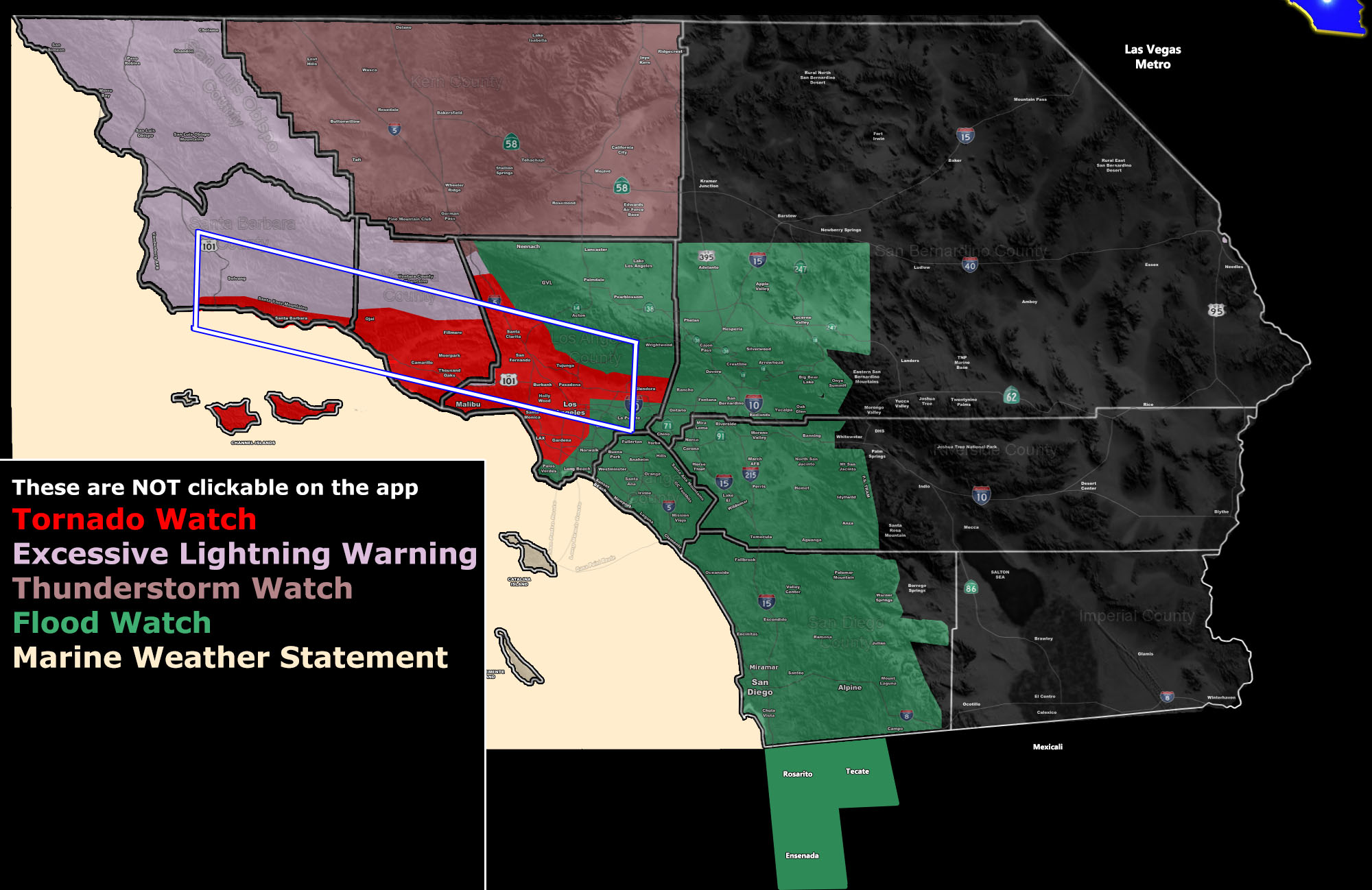
Rain did move in overnight and is remaining in some locations. This is the warm-front and it’ll lift through most of today. Offshore lightning detection via satellite shows lightning strikes in the unstable part of the system. This unstable part will move in later today, lasting on and off overnight for the Excessive Lightning Warning zone, centering Ventura/Santa Barbara County overnight (Click here to view it).
Ahead of it however, southeast flow is prominent today and this will contribute to low-level shear. Any storms that move through the area will have the risk of strong waterspouts and/or small tornadoes. The SCWF Tornado Watch issued yesterday is for this reason. Click here to view it.
The Flood Watch in place south and west of the mountains looks good. Most areas inland will see the heavier rains with the least as usual along the San Diego/OC coastal areas. Click here to view the Flood Watch.
Now given this system does re-develop the central core south of the area on Thursday, this may surprise whoever is not reading this paragraph. As stated in my forecast video which I’ll link below, Thursday’s southeast/east flow into the area will bring a ‘monsoonal’ type flow, or reversal in the normal wind flow in the middle/upper levels. This will surge moisture into the region and with developing instability, I do think that we will see the most widespread risk of thunderstorms from Los Angeles, OC/SD, and all High/Low Desert regions then.
Today seems to be the LA/Ventura/Santa Barbara/Kern/SLO County areas for the most thunderstorm activity… but on Thursday we will switch to more of the zones we usually see in the Summer Monsoon. The green-shade on the lower right of the article image if of notable rainfall, the yellow is a possible flood watch need, which does include the Morongo Basin and the Needles forecast zones, possibly even the Coachella Valley. I will be issuing the watch today should trends continue. I will not need to issue anything for the Inland Empire or Victor/Lucerne Valley areas of the yellow-shade because you are already in one through Thursday.
Join Southern California Weather Force main Facebook Page for future updates!
MICRO-CLIMATE ALERT FACEBOOK GROUPS: Find yours today!
Click here to join
Reading for another state? Join my national page – https://www.facebook.com/nwfweather/
All articles and micro-climate alerts can be delivered to you via the app/email alert service subscription so Click Here To Check It Out And Join Today and NEVER miss a beat
MICRO-CLIMATE ALERT FACEBOOK GROUPS: Find yours today!
Click here to join
As always, stay tuned to official forecasts from Southern California Weather Force for updates …
For The Main Weather Facebook Page Click Here and Join.
End Article
FACEBOOK PAGES TO JOIN!
SOUTHERN CALIFORNIA WEATHER FORCE MAIN: Southern California Weather Force Office Main Page
BEHIND THE SCENES FORECASTS/UPDATE PAGE: Southern California Weather Force Meteorologist Page
FOR THE CALIFORNIA FAULT STRESS MODEL PAGE: For SCWF official updates to the California Fault Stress Model and more!
“PONDER THIS” SCIENCE ADVENTURE SHOW: A science adventure show developed here at Southern California Weather Force that is a fun ride!
INSTAGRAM AND TWITTER ACCOUNTS TO JOIN!
Instagram – https://www.instagram.com/socalweatherforce/
Twitter – https://twitter.com/SCweatherforce
\