

Yesterday the storm looked a bit weaker through the weekend, however this morning I saw a shift to the west, meaning an over-water trajectory is becoming more likely and this will up the strength of it and thus Pacific Storm ASGARD is now official, the first name in the 2020-2021 storm season. Wind, Rain, Snow, and even Thunderstorms are in my forecast grids and I have issued 5 alerts in various areas of Southern California. One thing I will note to you is the metro winds will be stronger than anyone else is seeing so as long as you read what I put, you won’t be caught off-guard if trees/lines come down so read on for details …
REMEMBER: Get these from the new app for notification – National Weather Force Android/IOS App notification system and you can find it here for free and never miss a post on this page again,
Download Today at – http://www.nationalweatherforce.com/2020/07/fb-weather-phone-app/
The following below are micro-climate alerts issued over the e-mail alert system for zones. Also on FB groups so Find yours today! – Click here to join
The Storm Statement was issued for All metro/coast/basin areas south and west of the mountains …It reads with a link here as well – https://www.southerncaliforniaweatherforce.com/2020/11/05/storm-statement-5/
A double-barreled storm system will impact the region over the weekend, bringing rain and gusty, sometimes damaging winds to the area, including the metro zones. Winds of this nature will be strong and thus when the official article does come out, Pacific Storm ASGARD will be officially named.
This system has been getting stronger with each passing 6-12 hour period and yesterday it looked a bit weaker overall, but today it looks stronger so it will have a name. I’ll start it at a category three today and if thunderstorms ‘continue’ to look possible it in the forecast area then it will be raised to category four. The storm will hit Saturday with rounds and then again on Sunday.
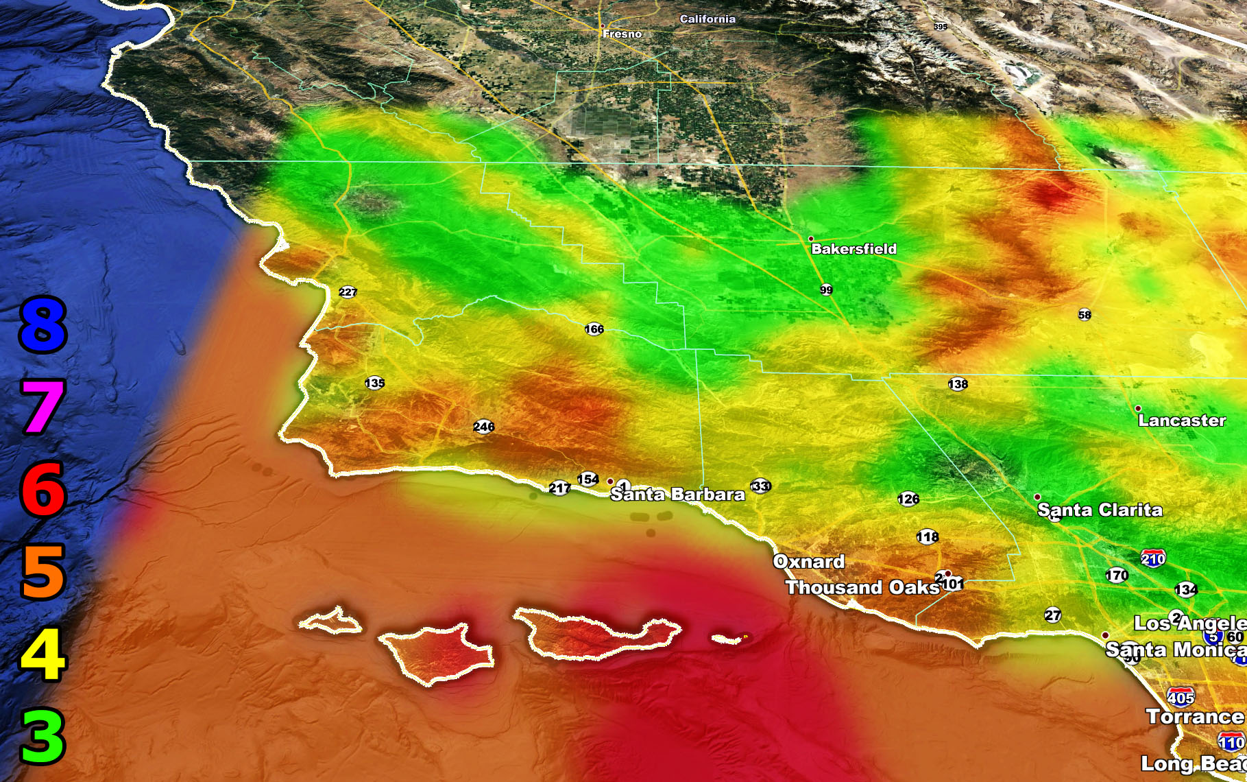
This system has multiple fronts with it so with each passing dynamic the wind will be strong out there. Some of the grids here at SCWF shows damaging winds in the metros with widespread intensity 4 and 5 wind gusts in the Storm Statement area. Look below to find your intensity the wind will surprise everyone in the metros because this forecast is not anywhere else so as long as you know and are reading this, you’re good to go. Flooding will be possible in spots south and west of the San Bernardino/Riverside/San Diego Mountains. Sliders like this tend to have a southwest to northeast low level flow favoring these areas so I’d prepare today for 1-2″ of rainfall in the El Dorado burn areas. Rainfall maps will be given out later on Friday on the SCWF Facebook Page.
The High Wind Warning and Wind Advisory was issued for All Deserts … Kern Valley … Las Vegas Metro …San Diego Foothills/Mountains … it reads with a link here as well – https://www.southerncaliforniaweatherforce.com/2020/11/05/high-wind-warning-and-wind-advisory-5/
A double-barreled storm system will make its way into Southern California over the weekend. However, on Friday, southwest winds ahead of it will start the advisories and strengthen each day Saturday and Sunday. The 4-zone models below will show you what areas will see the worst in the forecast area based on my intensity scale.
The wind intensity charts for the Storm Statement, High Wind Warning, and Wind Advisory can be viewed below –
8. Extensive widespread damage.
7. Trees are broken or uprooted, building damage is considerable. – High Profile Vehicle Roll-Over CERTAIN.
6. SOME Trees are broken or uprooted, building damage is possible. – High Profile Vehicle Roll-Over Likely, Do NOT recommend Traveling in this zone
5. Slight damage occurs to buildings, shingles are blown off of roofs. HIGH WIND WARNING CRITERIA – High Profile Vehicle Roll-Over Possible if weight is not corrected.
4. Twigs and small branches are broken from trees, walking is difficult. Anything 4 and above will have blowing dust if conditions are dry, which does reduce visibility and make driving difficult …
3. Large trees sway, becoming difficult to walk. POWER SHUTDOWN THRESHOLD during any high fire risk. WIND ADVISORY CRITERIA


In addition to that, for the mountains of Kern, Los Angeles, San Bernardino, Riverside Mountains over 4,000 FT I issued a Winter Weather Watch …it reads with a link here as well – https://www.southerncaliforniaweatherforce.com/2020/11/05/winter-weather-watch-8/
Well finally the first snow of the season hits this weekend, although not as strong, it still is a welcome sight. A double-barreled system will move down the coast and start rain in the Kern areas as early as later Friday.
The cold air will arrive on Saturday across the watch areas with a snow-level of 4000-5000 FT for the Kern areas and 4500-5500 for the LA/SBD/RIV Mountain zones and there it will remain all weekend.
Wind will accompany the system, however since my grids do not show a whole heck of a lot of snow, the winter weather watch turning advisory seems appropriate. A Winter Weather Watch means conditions are favorable in the watch area for any type of falling snow, which turns into the final winter weather advisory on Friday evening so look for that to come next. But… wind will hit well before this hits on Friday so keep in mind all areas in this watch area in a wind alert as well.
Snow amounts will be given on Friday evening … It’ll be a tough one because this is a hybrid inside slider / over-water trajectory system, which means Running Springs to Snow Valley will see much more than Crestline and Bear Valley Springs (Kern) will see more than Pine Mountain Club.
I do NOT see this as a mountain pass closing event …
And finally the island region and ocean activities alerts, the Marine Weather Warning … It reads with a link here as well – https://www.southerncaliforniaweatherforce.com/2020/11/05/marine-weather-warning-14/
As always, stay tuned to Southern California Weather Force for official forecasts and updates in weather across Southern California
Join Southern California Weather Force main Facebook Page for future updates!
MICRO-CLIMATE ALERT FACEBOOK GROUPS: Find yours today!
Click here to join
Reading for another state? Join my national page – https://www.facebook.com/nwfweather/
FACEBOOK PAGES TO JOIN!
SOUTHERN CALIFORNIA WEATHER FORCE MAIN: Southern California Weather Force Office Main Page
NEWS REPORT BANDIT: Tired of Politics and Celebrities and want funny, interesting, weird stories, including science like solar storm, earthquake, volcano, space stories updated 1-2 times a day?
FOR THE CALIFORNIA FAULT STRESS MODEL PAGE: For SCWF official updates to the California Fault Stress Model and more!
PROJECT DESTINI WORLDWIDE QUAKE PREDICTION – A system that shows worldwide plate stress due to numerous factors
INSTAGRAM, TWITTER, and NOW TIKTOK SHORTS ACCOUNTS TO JOIN!
Instagram – https://www.instagram.com/socalweatherforce/
Twitter – https://twitter.com/SCweatherforce