
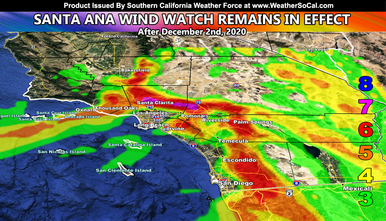
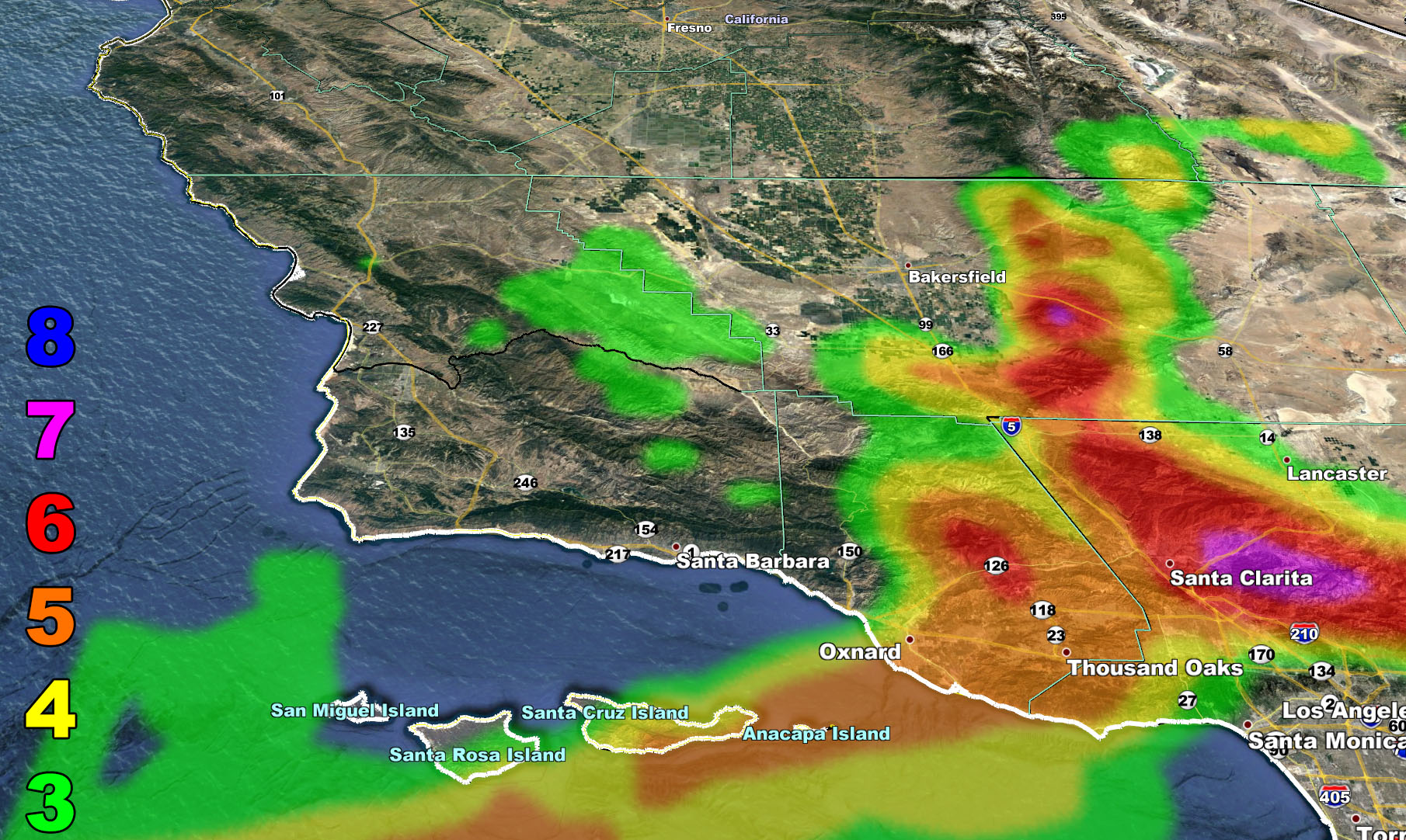
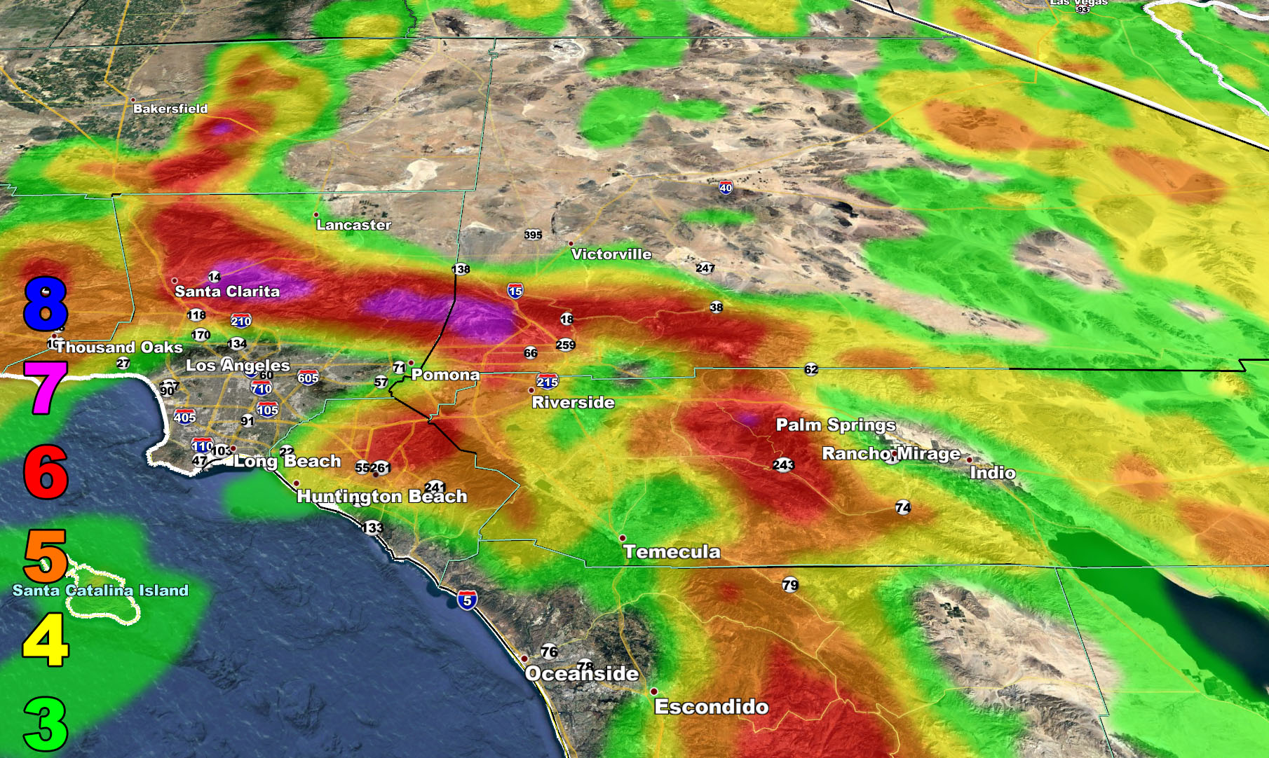
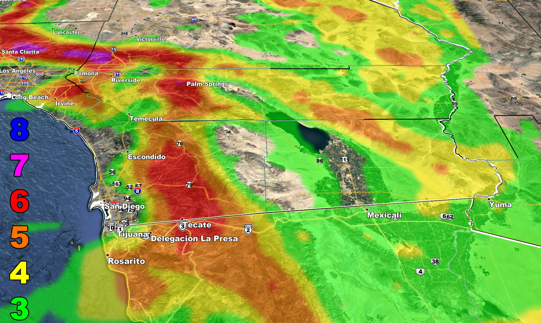
A Santa Ana Wind Watch was issued here at Southern California Weather Force on November 27th and it remains in place as of this update for all Santa Ana Wind Prone zones along with a solar flare eruption due to sideswipe Earth December 1st to 2nd so read on for details …
A very rare pattern where a ridge of high-pressure forms over the Pacific Northwest for drier weather along the entire west coast; from Washington to California, will happen the first week of December. This projection was seen back on November 27th, and it remains seen today. A storm system will move down through Nevada and Arizona after the 2nd of the month. This system is dry, so it is not expected to bring any storm activity to the states it crosses. What is not dry about the system is the mid/upper jet stream associated with it. Systems attacking from the northeast will bring a northeast/easterly flow across the area, with enough upper support to warrant a strong offshore event, and the watch looks good right now.
As stated in the PREVIOUS ARTICLE, this does have an easterly component to it, so the San Diego County Mountains do stand to have a damaging wind event, including down into Northern Baja around Rosarito and Tecate. Over the next couple of days, Santa Ana Wind Watches will be upgraded to warnings. The current SCWF wind model intensity images are below. Premium Facebook Supporters please CLICK HERE to the supporter thread where you can go to the premium members section for December and see zoom-in controllable models where you type your address in and it zooms right to it. If you are not a Facebook Page Premium Supporter, CLICK HERE and join –
This same system causing these winds will send upper-level lows well south of here, and this will scoop up moisture down in the tropics. The preliminary December 2020 forecast calls for a ridge out in the Eastern USA after December 9th, with troughs in the Western USA, so this will be the timeframe to watch for the storm window to start opening. The final December 2020 forecast is going to be this evening; or tomorrow, December 1st, between 11:15 am – 11:30 am.
8. Extensive widespread damage.
7. Trees are broken or uprooted, building damage is considerable. – High Profile Vehicle Roll-Over CERTAIN.
6. SOME Trees are broken or uprooted, building damage is possible. – High Profile Vehicle Roll-Over Likely, Do NOT recommend Traveling in this zone
5. Slight damage occurs to buildings, shingles are blown off of roofs. HIGH WIND WARNING CRITERIA – High Profile Vehicle Roll-Over Possible if weight is not corrected.
4. Twigs and small branches are broken from trees, walking is difficult. Anything 4 and above will have blowing dust if conditions are dry, which does reduce visibility and make driving difficult …
3. Large trees sway, becoming difficult to walk. POWER SHUTDOWN THRESHOLD during any high fire risk. WIND ADVISORY CRITERIA

SUNSPOT AND SOLAR FLARE UPDATE – A sunspot on the far side of the Sun put out an M-class solar flare yesterday. The resulting explosion on the Sun has a chance at having a glancing blow at the Earth between December 1st and 2nd. This will cause a G1 geomagnetic storm. Elevated worldwide quake activity will be possible then.
-
- These storms can cause weak power grid fluctuations;
- Minor impact on satellite operations is possible;
- These storms can have an effect on migratory animals in northern regions.
AURORA
G1 (Minor) storm events can produce many hours of vibrant auroras across the Northwest Territories, Nunavut, and Yukon. Periods of active auroras can also be seen at mid-latitudes (southern Canada and the northern United States), including British Columbia, Alberta, Saskatchewan, Manitoba as well as northern Ontario, northern Quebec, and northern Newfoundland & Labrador.
REMEMBER: Get these from the new app for notification – National Weather Force Android/IOS App notification system and you can find it here for free and never miss a post on this page again,
Download Today at – http://www.nationalweatherforce.com/2020/07/fb-weather-phone-app/
Southern California Weather Force is NOW on MeWe – https://mewe.com/p/southerncaliforniaweatherforce
As always, stay tuned to Southern California Weather Force for official forecasts and updates on weather across Southern California
Join Southern California Weather Force main Facebook Page for future updates!
MICRO-CLIMATE ALERT FACEBOOK GROUPS: Find yours today!
Click here to join
Reading for another state? Join my national page – https://www.facebook.com/nwfweather/
FACEBOOK PAGES TO JOIN!
SOUTHERN CALIFORNIA WEATHER FORCE MAIN: Southern California Weather Force Office Main Page
NEWS REPORT BANDIT: Tired of Politics and Celebrities and want funny, interesting, weird stories, including science like solar storm, earthquake, volcano, space stories updated 1-2 times a day?
FOR THE CALIFORNIA FAULT STRESS MODEL PAGE: For SCWF official updates to the California Fault Stress Model and more!
PROJECT DESTINI WORLDWIDE QUAKE PREDICTION – A system that shows worldwide plate stress due to numerous factors
INSTAGRAM, TWITTER, and NOW MEWE ACCOUNTS TO JOIN!
Instagram – https://www.instagram.com/socalweatherforce/
Twitter – https://twitter.com/SCweatherforce