

A weak system will sneak through the area on Thursday, starting as early as tonight for San Luis Obispo and moving through the rest of the forecast area over the day on Thursday. High Wind Warnings have been issued for the Northern High Desert to the Tehachapi Mountains so for details in your area with the clickable SCWF model maps read on …
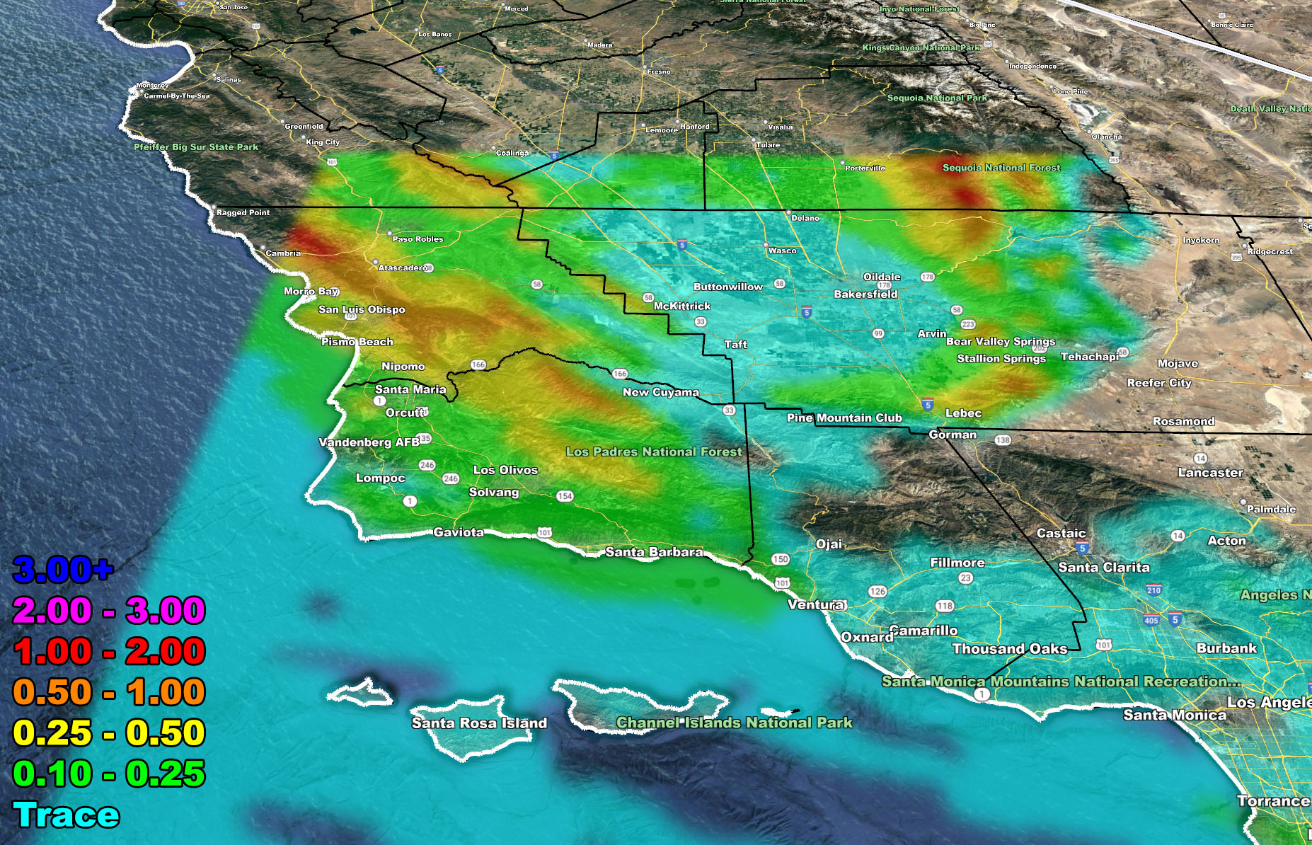
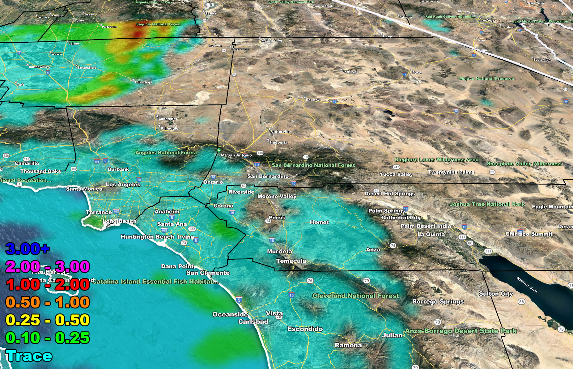
A weak system now moving through Northern California will weaken even further as it moves into the Southern California forecast area on Thursday. However, tonight into Thursday the frontal zone’s low-level forcing dynamics have much better lift across San Luis Obispo and Santa Barbara County with upslope activity for the Tehachapi Mountains. These places, especially San Luis Obispo; is where the most rain will fall with the system.
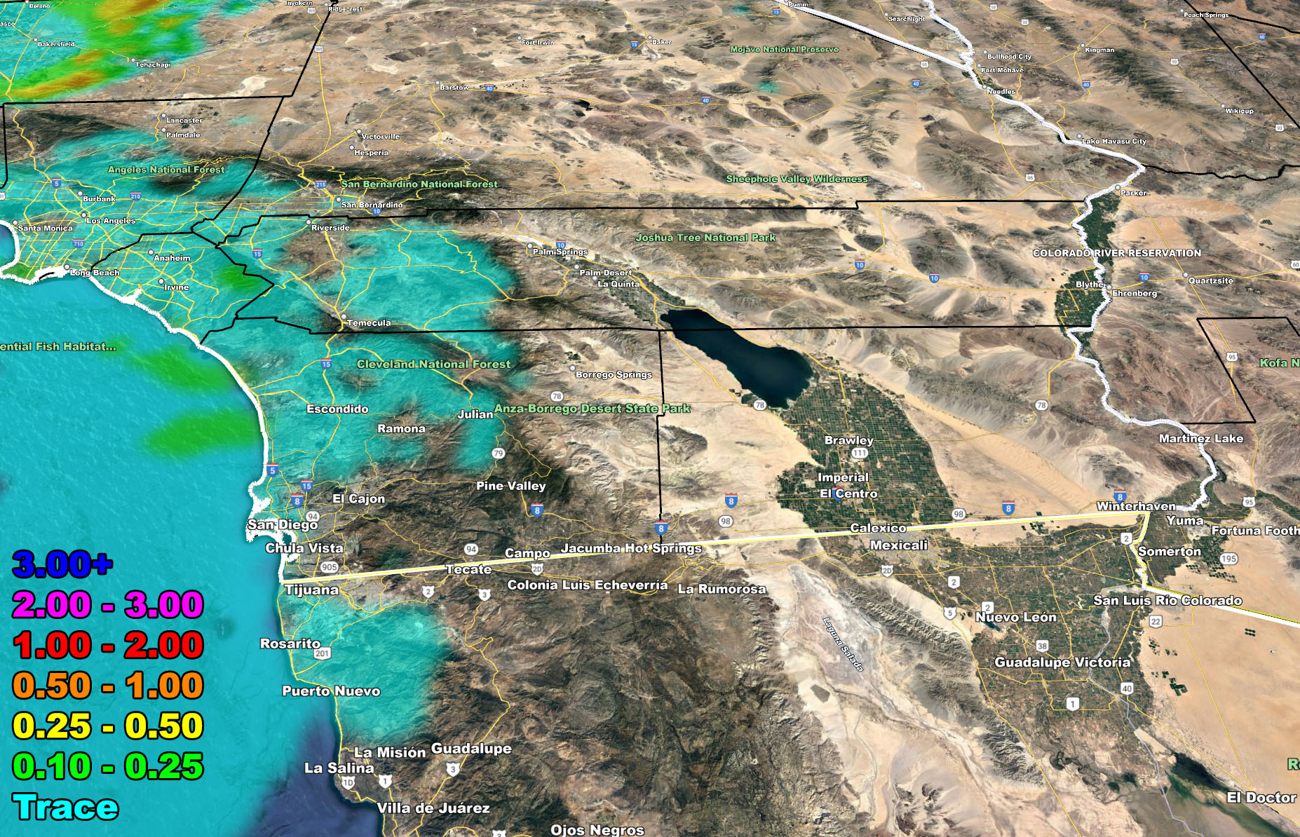
As Thursday moves along, expecting very light amounts for the rest of the Ventura, Los Angeles, Orange, San Diego, and Inland Empire metro areas. Again, not much at all so don’t get too excited.
With this system I have also brought the High Wind Warning out for the Tehachapi Mountains and the Northern High Desert areas like Barstow and Ridgecrest. Those images are below for wind and rain so have at them …
FRIDAY into SATURDAY: As the system moves east of the area, colder air in Nevada will work with thermal support and bring offshore winds (Santa Ana Wind Conditions) to the area. The extent of the strength is not known yet, but they should be rather wrong in the mountain passes … and alerts, if needed, with the SCWF wind gust models, will be given 18-24 hours before the event hits, but you have your outlook now for them …
LONG RANGE: Storm after storm should hit California starting around December 21st and going into the end of the month. These will trail into our region as well …
Join the Facebook Page for Further Updates
SOUTHERN CALIFORNIA WEATHER FORCE MAIN:
OFFICIAL issued Southern California Weather Force Alerts by location – Valid Thursday December 16, 2021
High Wind Warning – Tehachapi Mountains … Kern Deserts … Barstow …
Short Term Forecast – Kern, San Luis Obispo, Santa Barbara County … Ventura, LA, OC, San Diego Coast/Basin, The Inland Empire …
There are 10 counties in the Southern California Weather Force forecast area and the storm is major so I cannot write about each micro-climate sector in this article. I however can show you the images in the SCWF model suite and you will need to know where you are on a map to read them. Everyone should know where they are on a map so this is no excuse.
The maps below are of flood, rain, snow, snow-level, and wind intensity. Each one is clickable. Map 1 is NW SoCal, Map 2 is SW SoCal, Map 3 is SE SoCal, Map 4 is NE SoCal, Map 5 is the Cajon Pass, and Map 6 is the SCV region, which includes Gorman at the top.
GET TO KNOW YOUR MAP BECAUSE THESE NEVER CHANGE LOCATIONS – Click Here for the GPS Member Section if you are a FULL MEMBER
Rain – Valid Thursday December 16, 2021


Wind Risk – Valid Thursday December 16, 2021
Martin Wind Gust Intensity Scale –
8. Extensive widespread damage.
7. Trees are broken or uprooted, building damage is considerable. – High Profile Vehicle Roll-Over CERTAIN.
6. SOME Trees are broken or uprooted, building damage is possible. – High Profile Vehicle Roll-Over Likely, Do NOT recommend Traveling in this zone
5. Slight damage occurs to buildings, shingles are blown off of roofs. HIGH WIND WARNING CRITERIA – High Profile Vehicle Roll-Over Possible if weight is not corrected.
4. Twigs and small branches are broken from trees, walking is difficult.
3. Large trees sway, becoming difficult to walk. POWER SHUTDOWN THRESHOLD DURING FIRE WEATHER / WIND ADVISORY CRITERIA


I would suggest continuing to monitor the latest forecasts here at Southern California Weather Force, however you get them, either by the member email alert system, social media, or checking the main website daily for updates. The ABOUT section of this site will tell you all you need to know about it for navigation. Click here to read the about section.
WANT MORE? The MAIN PAGE of this website has every alert/article issued at current along with the main alert map that you can click to zoom in on what is issued for you from this office… CLICK HERE TO GO
GPS MODELS ENABLED FOR MEMBERS: CLICK HERE FOR THE MEMBER SECTION
How to get these alerts with a premium subscription via e-mail by micro-climate zone AND/OR Get the GPS models for this event on your device enabled? (100 percent delivery time)
Click Here To Join The Season Tier
Join The Main Southern California Weather Force Facebook Group (50 percent delivery time) – You can join the main SCWF page as well through that group.
Click Here To Join The Page Today
FACEBOOK PAGES TO JOIN!
SOUTHERN CALIFORNIA WEATHER FORCE MAIN: Southern California Weather Force Office Main Page
SOUTHERN CALIFORNIA WEATHER FORCE METEOROLOGIST: – Just my public figure page that isn’t as large so maybe you can reach me better at times.
INSTAGRAM, TWITTER, TO JOIN!
Instagram – https://www.instagram.com/socalweatherforce/
Twitter – https://twitter.com/SCweatherforce
Southern California Weather Force is a custom weather alert service that began in September 1999 off and is regarded as the most accurate weather service in the region, offering custom alerts, maps, and models to help save life and property. The work done here is never 100% accurate, but it comes pretty close. Southern California Weather Force runs on zones, so if an event happens in a zone that is 10 miles from the border of your zone, the forecast is still valid to activate your zone’s alert system. A company quote to the public is that of “The Joker” and tells other agencies in weather this all the time… “This world deserves a better class of meteorologist… and I’m gonna give it to them”… out-forecasting even the National Weather Service with lead-time and precision, which makes this service a focus of ridicule and envy in the weather community due to having such accuracy. Alerts issued here are issued custom from this office and this office alone. You may not even hear it elsewhere, but if one is issued near or in your area, listen up because “if you do not wish to die in weather, follow, it’ll save your life one day.”