
This article by reading on will have a recap of the system on Friday and Saturday that we just had followed by the coming change in the weather once again as we continue this see-saw pattern across the South-land so read on.
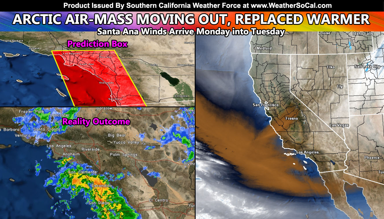
Let’s recap the Friday and Saturday systems. A category three was issued in the previous article for this with thunderstorms in the cards. Now, given what I have gone over, scientifically the thunderstorm watch box was perfect, having many thunderstorms across the central part of it for areas like Vista, which was dead center of the box. On Thursday evening I issued a Thunderstorm Watch via the main Southern California Weather Force Facebook Page in image form for Friday morning. Thunderstorms formed west of Los Angeles, Orange, and San Diego County and moved eastward. You can find that box by clicking here.
Furthermore, the previous forecast stated that Saturday would have some more activity in the region, especially closer to the mountain/foothill zones, even someone wondering if their son’s birthday party in Fontana would have issues. I did reply to them that it would so hope they got a tent or something. Given that, both days did not need updates and the forecast on both looked great.
Also, I did state we would have an arctic air-mass into the region the first/second week of this month, back on February 24th. Click here for that … We did have snow down through Yucaipa, which makes it a low-elevation snow event, even some through the Banning/Beaumont area for Saturday. This long range forecast was also on target.
SANTA ANA WINDS: A return of the winds below passes and canyons behind this arctic air-mass will happen both Monday and Tuesday. I will update the member section for members with wind models soon as well as issue the advisories across the alert system. It is not expected to be a major event, more of a drainage type event.
Now for the rest of the next 10-14 days. Best thing I can do is warmer air by around the 13th-15th onward with 80s returning to the valleys and comfortable temperatures elsewhere. With the storm pattern missing to the north again, we open the door for more Santa Ana Wind patterns.
So there you have it … all was on track and IS ON TRACK for the March forecast issued a week ago. No changes are to be expected at this time … Enjoy the second/third week of this month with nice weather …
he following articles pertained to the analysis and prediction of this forecast …
February 24, 2022
Warm Up Expected Across The Southern California Metros This Next Week Followed By A Return Of The Arctic Air Masses In March
March 3, 2022
Official SCWF Thunderstorm Watch Issued For Friday Morning’s Event
FACEBOOK PAGES TO JOIN!
SOUTHERN CALIFORNIA WEATHER FORCE MAIN: Southern California Weather Force Office Main Page
SOUTHERN CALIFORNIA WEATHER FORCE METEOROLOGIST: – Just my public figure page that isn’t as large so maybe you can reach me better at times.
INSTAGRAM, TWITTER, TO JOIN!
Instagram – https://www.instagram.com/socalweatherforce/
Twitter – https://twitter.com/SCweatherforce
Southern California Weather Force is a custom weather alert service that began in September 1999 off and is regarded as the most accurate weather service in the region, offering custom alerts, maps, and models to help save life and property. The work done here is never 100% accurate, but it comes pretty close. Southern California Weather Force runs on zones, so if an event happens in a zone that is 10 miles from the border of your zone, the forecast is still valid to activate your zone’s alert system. A company quote to the public is that of “The Joker” and tells other agencies in weather this all the time… “This world deserves a better class of meteorologist… and I’m gonna give it to them”… out-forecasting even the National Weather Service with lead-time and precision, which makes this service a focus of ridicule and envy in the weather community due to having such accuracy. Alerts issued here are issued custom from this office and this office alone. You may not even hear it elsewhere, but if one is issued near or in your area, listen up because “if you do not wish to die in weather, follow, it’ll save your life one day.”