
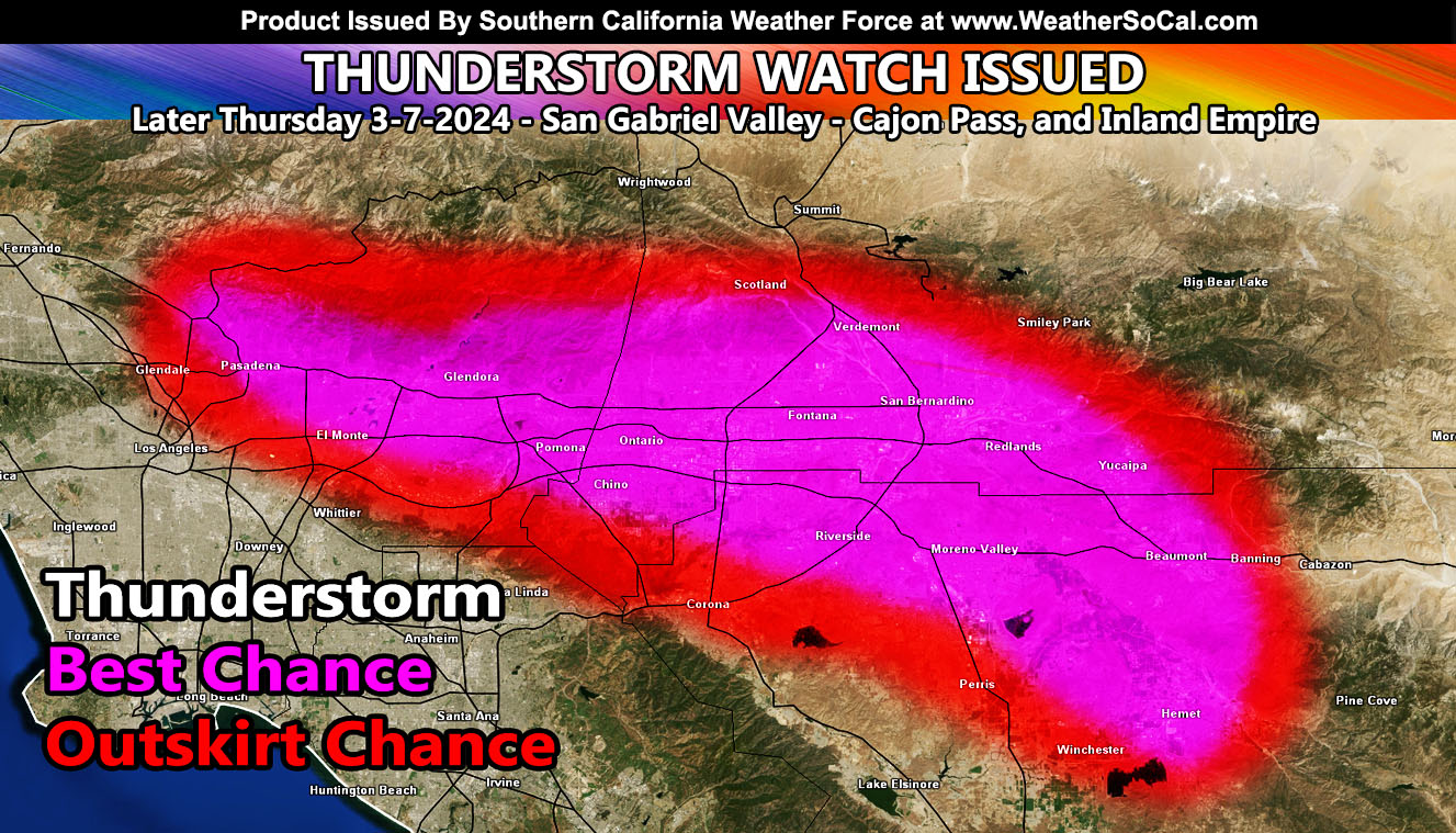
Southern California Weather Force has issued a Thunderstorm Watch effective later today (Thursday) for the following areas: San Gabriel Valley, Cajon Pass, Inland Empire, including Ontario to Yucaipa as well as Hemet to Banning.
The frontal zone that passed yesterday has moved to the east into Arizona. The backside area of this system has a northwest flow with it. As stated in the initial forecast for this storm, I did clearly state we would have a chance of backside activity (See Reference A). This activity will be an onshore flow into the southern slopes of the Los Angeles and San Bernardino Mountains this later afternoon and evening. As that happens, the northwest flow and attended instability will bring a convergence zone there.
This convergence zone will develop updrafts along it, capable of producing thunderstorms. Hail, Funnel Clouds, and brief heavy downpours will be likely with it.
As the graphic shows, the magenta zones have the best chance at producing thunderstorms, while the red-shade zones will be a ‘chance’ for them to leak into the areas. Those magenta zones again will from along the San Gabriel Valley zones, Ontario, Fontana, Cajon Pass, Yucaipa, Riverside, Hemet, and Banning. Here in Corona, we are south of the convergence zone. So while you may have gotten the alert on the member only app, it is the outskirts and not a focus spot, but this evening we will see the lightning to the north of us.
LONG RANGE: Mid-month, around 12-14 March period we could see a return of the Santa Ana Winds. I will maintain to follow-up on that pattern, but till then, that is all.
Reference A (Last paragraph call) – https://www.southerncaliforniaweatherforce.com/2024/03/04/southern-slider-system-to-graze-southern-california-on-wednesday-march-4-2024-rain-model/
Stay tuned to Southern California Weather Force for more updates on this and other future events.
– Raiden Storm –
https://www.southerncaliforniaweatherforce.com
Master General Meteorologist – is a consulting meteorologist for over 50 companies, including energy, agriculture, aviation, marine, leisure, and many more areas. He has certs from Mississippi State for broadcast met and Penn State forecasting certs MET 101, 241, 341 and 361 as a meteorologist, but before then was completely self-taught, barely learning a thing from the schools that he did not already know.
Both short and long-range is very important to know in those jobs so you can bet on accuracy here. He is versed in fields like Western USA, Tornadoes, Floods, Hurricanes, High Winds, Fire Behavior, Snow and Blizzards, Short Range, Long Range, Seasonal, and Life-Threatening decisions with over 25 years’ experience, out forecasting all weather services available today with lead-time and precision, which makes him a focus of ridicule and envy.
NOTE: Alerts are posted on here, be it a tornado watch, etc, and these alerts are issued from this office and nowhere else. At times, which is often, you will see an alert forecast posted on here that you do not see elsewhere.