
Pacific Storm URSULA has remained a category three thus far with the most impact as forecast being the thunderstorms. Numerous thunderstorms have affected Santa Barbara and Ventura and the dynamics are heading eastward to Los Angeles, Orange, San Diego County, and the Inland Empire, as far north as the High Desert and possibly as far east as the low deserts later on. Major Pacific Storm Vladimir nails the forecast area on Saturday with damaging winds, enough to damage cars and harm people and animals when falling. Read more for details.
At 3:10p yesterday, Wednesday, January 30, 2019, I issued a thunderstorm watch (click here) for areas west of Los Angeles County. This ignited with numerous thunderstorms early this morning and this activity is streaming eastward at a pretty good pace. Hail is being detected in some of these cells as well as some funnel clouds and offshore waterspouts.
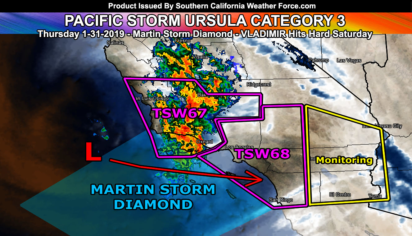
The most recent official Thunderstorm Watch here at Southern California Weather Force is TSW-68, which goes for the following zones for today; Los Angeles and Orange County … San Diego Coast/Valley … The Inland Empire … High Desert … LA/SBD/RIV/SD Mountains …The Martin Storm Diamond has been activated and the center of the upper system (Pacific Storm URSULA C3) will pass the northern part, putting a large part of metro Southern California within the thunderstorm risk zone, some areas seeing numerous lightning strikes and some isolated. The Martin Storm Diamond is a diamond-shaped area offshore that I discovered does, in fact, give the best chance of widespread thunderstorms to our region if instability is present, which it will be. Thunderstorms have already erupted in the thunderstorm watch to the west in Ventura and Santa Barbara County so this looks good. Given what I see the most rain and thunderstorm activity will mountains south to the metro basin/coastal/valley zones, however, the risk of thunderstorms in this unstable air will extend as far as the Antelope Valley and Metro High Desert zones from Hesperia to Barstow as well. There is also a risk of waterspouts to weak tornadoes at the coast of Los Angeles, Orange, and San Diego County where my Waterspout Watch is shaded … Other than that.. the system is not much of a ‘far inland’ tornado producer but CAN have funnel clouds spotted during the day.
This will replace parts of the Flood Advisory product issued earlier
So the agenda for today will be continuing to monitor the Thunderstorm Watch 68 product and see how far east I can extend the thunderstorm dynamics. I do see the upper divergent (lifting zone) of Pacific Storm URSULA making it into the Imperial Valley through the San Diego County Mountains so this bears watching for the elevated risk of shower and/or thunderstorm activity there. Your micro-climate Facebook Groups I have in links below will have those alerts so join them.
MAJOR PACIFIC STORM VLADIMIR
This system hits on Saturday and will be the strongest damaging wind frontal zone system thus far this season with gusts easily topping the 50+ mph range with the front, especially at the coast and some miles inland. VLADIMIR has an extremely powerful surface low and it’ll work with a strong jet to push the gusts into the surface so with that being said VLADIMIR will be a damaging storm with trees toppling on cars and possibly any people or animals in the way. This will also bring flooding rains to ALL burn areas and Flood WARNINGS will be needed. VLADIMIR does at this point lack frontal zone thunderstorm dynamics where URSULA does not. URSULA is taking on the thunderstorm dynamics at a category 3 lacking the frontal zone winds and VLADIMIR is going to be a stronger category simply because of the damaging winds I expect.
Snow levels with VLADIMIR on Saturday will be around 6,000 FT for sticking snow in the Gorman areas and 6,300 to 6,700 FT for the LA / San Bernardino Mountains and possibly somewhat higher in Riverside’s Mountains with warmer air advection. Those will lower after the front so I do believe some resort zones will see good accumulating snowfall this weekend … enjoy it …
Stay tuned to Southern California Weather Force on Facebook (Click Here) for official forecast updates …
We continue this pattern off and on for a while so click here for that article
End
NOTE: Premium members. If you are signed up, your login is your e-mail address and the username and password as the password. You can change the password
Ongoing Ad – The Southern California Weather Force has a member section with LIVE UPDATES FOR EVENTS and rain, wind, thunder, tornado etc models that are personally updated by me with each Santa Ana Wind or storm event. You also can get e-mailed alerts via a slew of micro-climates. Check the member section for details on how you can support this service.. along with getting service in return… Click Here To Join or Upgrade Via The Member Section
Please remember if upgrading to CANCEL YOUR PAYPAL PAYMENTS. Login and cancel the reoccurring payments.
The Southern California Weather Force has different Facebook groups that you can ask for notifications from in order to get the latest posts affecting those regions. If that area is talked about in an article, alert, and such .. it’ll be posted there and you can be notified.
Comments are usually DISABLED as we do like to keep this as an information giving group and replies from others in the notification may annoy some.
Find your micro-climate group here – https://www.southerncaliforniaweatherforce.com/scwf-weather-alert-facebook-groups-by-region/
EMAIL ALERTS? Many micro-climate zones to choose from to get custom alerts from thunderstorm, wind, flood, surf, heat, cold, storm, and much more with the premium e-mail alert system, the most advanced zone alert system in Southern California – Click Here To Join!
SOUTHERN CALIFORNIA ONLY: if it does not say “Liked” LIKE The Page Below and join thousands of informed weather forecast viewers in our region for more of the updates! noticeable
BEHIND THE SCENES FORECASTS/UPDATE PAGE: if it does not say “Liked” LIKE The Page Below and join thousands of informed weather forecast viewers in our region for more of the updates! noticeable