
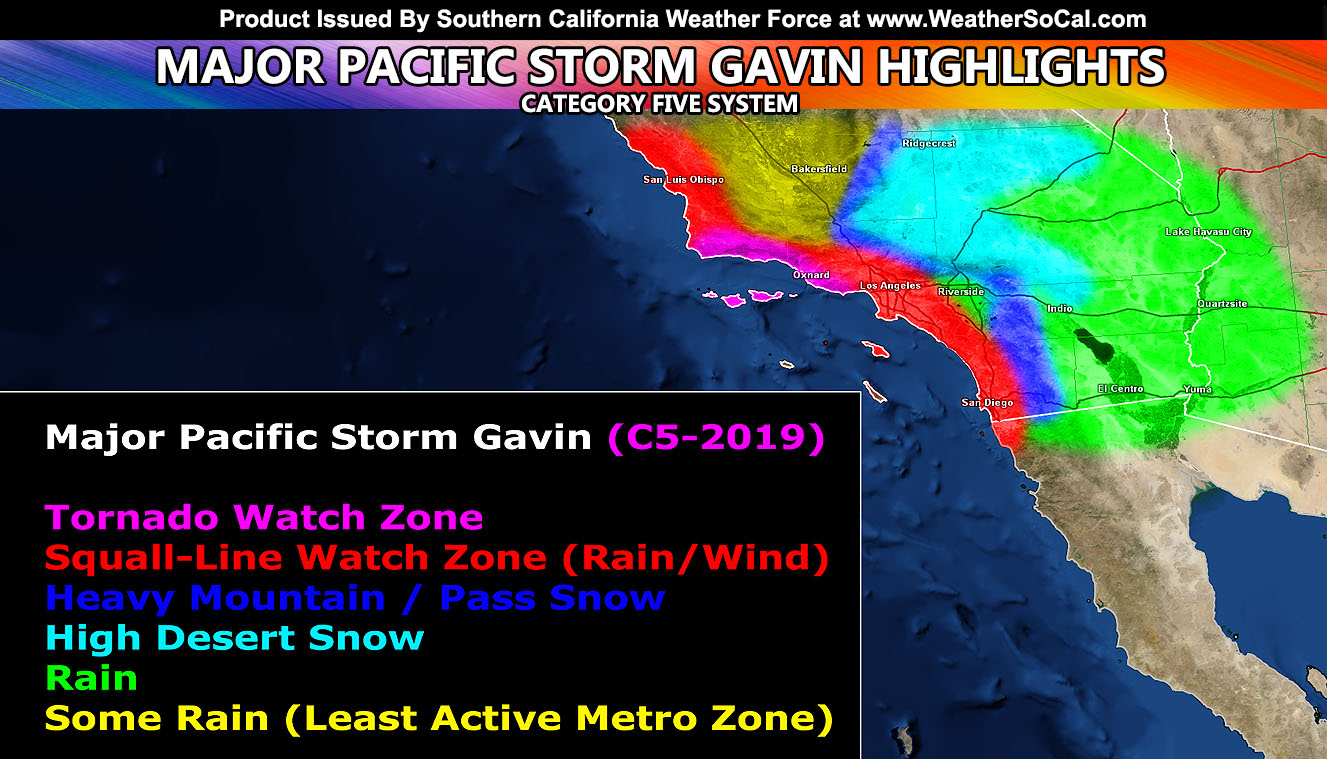
In what could very well be a once in every 10-15 year storm for the Gorman and Cajon Pass regions like the December 17, 2008 storm, Major Pacific Storm Gavin is maintaining a category five status and a Tornado Watch has been issued here at Southern California Weather Force along with Winter Storm Warning alerts in the high desert areas so for your area’s details, read on and look at the embedded maps provided from snow, rain, and flood.
Join Southern California Weather Force main Facebook Page for future updates!
Now before I get into much, each CLICK HERE link says what it is for and yes each one has my custom model images in it from snow, flood, etc. You have to go through each one you are interested in. Major Pacific Storm Gavin is popping thunderstorms west of San Luis Obispo and Monterey this afternoon. There are pre-frontal showers already in the area as previously forecast in my last article yesterday (click here to read) so that is not a surprise. The SCWF Tornado Watch is for Santa Barbara, Ventura, and Malibu’s forecast zones. The Tornado Watch is in effect for tonight, mainly from 6pm to 3am, however the Southern Vandenberg Coast may see it as early as 6pm. Another tough forecast, but one of the components with low level instability is lacking for thunderstorm development. We will see small hail at times and gusty winds, however with this line the SCWF Tornado Forecast Model is pegging areas of weak tornadoes being possible from Santa Barbara’s southern coast to Ventura and Malibu.
Looks like embedded rotation that would come ashore from stronger waterspouts and into the watch area. A Tornado Watch means that conditions are favorable in and around the watch area for tornadoes to move through. The thunder factor is iffy though but I can’t rule out an isolated one embedded.

As for the rest of the area. The storm is a cutoff surface low and as it sinks southward, the instability dynamics would remain in the bight. Not fully thinking I’ll need to extend the Tornado Watch to LA/OC/San Diego just yet but if I do it’ll be in the micro-climate alert system and FB groups in those zones. Just as of right now I do not see the need to expand from Ventura and Santa Barbara. The Squall-line Watch issued yesterday for the Los Angeles, Orange, and San Diego areas however remains in effect here at SCWF and this is for a squall-line to move through overnight tonight, probably after the 10pm hour and and really peaking during the early Thursday morning commute so if you have to return to work or travel, be aware the roads will be bad out there. The low-levels look to cool this evening above the convective tops so I’m thinking any thunderstorm dynamics would be immediately behind the forcing zone so I’m only remaining isolated lightning strikes being possible tonight through Thursday morning in the metros. Small hail is likely with these cells however.
With the squall-line watch comes the winds as well and these winds will be most gusty in the LA/OC/San Diego zones with the front and downed trees and poles are likely so don’t park near one as rain saturates the ground enough to make the fall happen.
The eastern extent out of LA/OC for gusty winds could be along I-15 through the Ontario, Mira Loma, Norco, and Corona zones but nothing further. Sure, you’ll have some winds along the front across other parts of the Inland Empire but nothing too strong in weather terms.
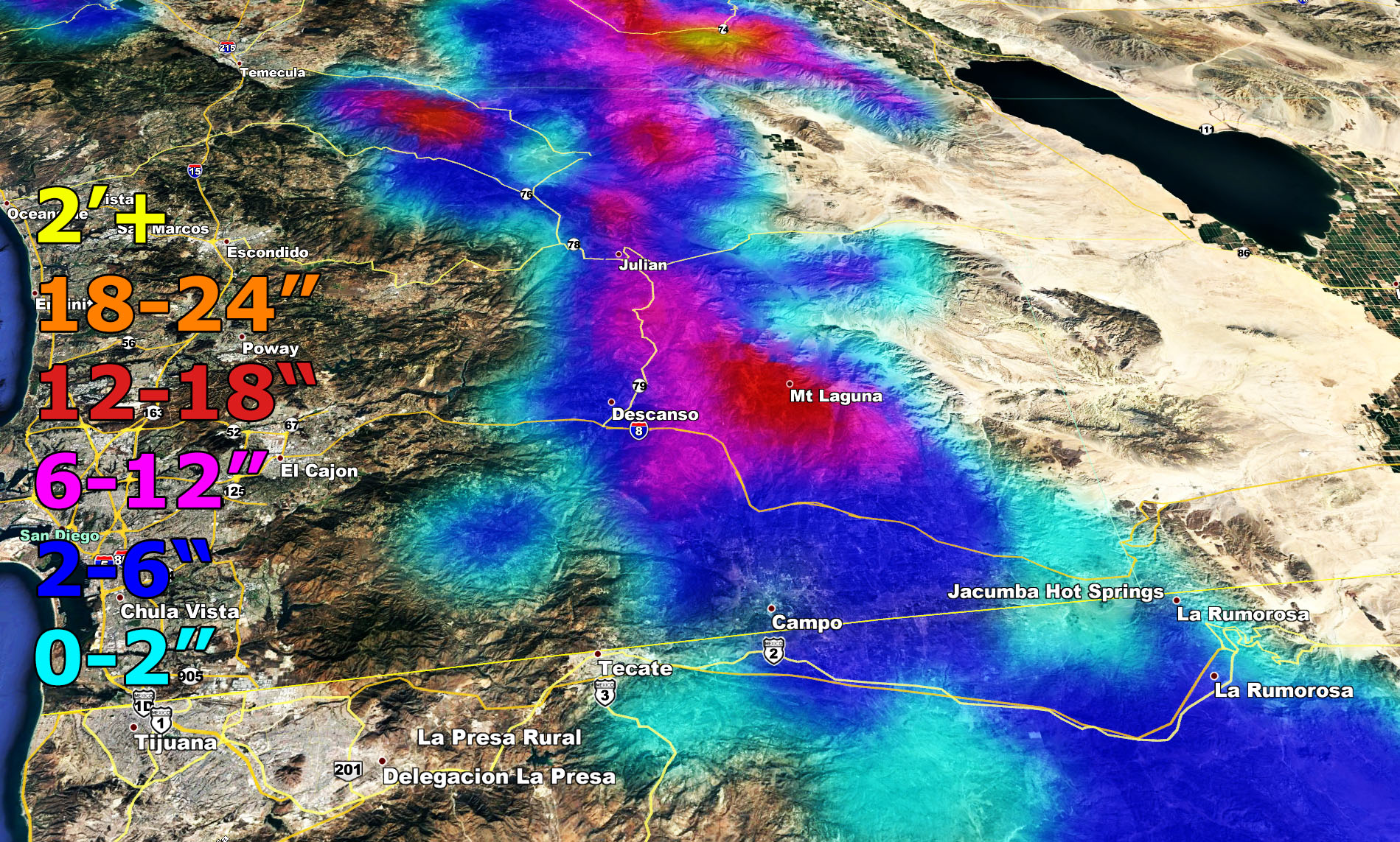
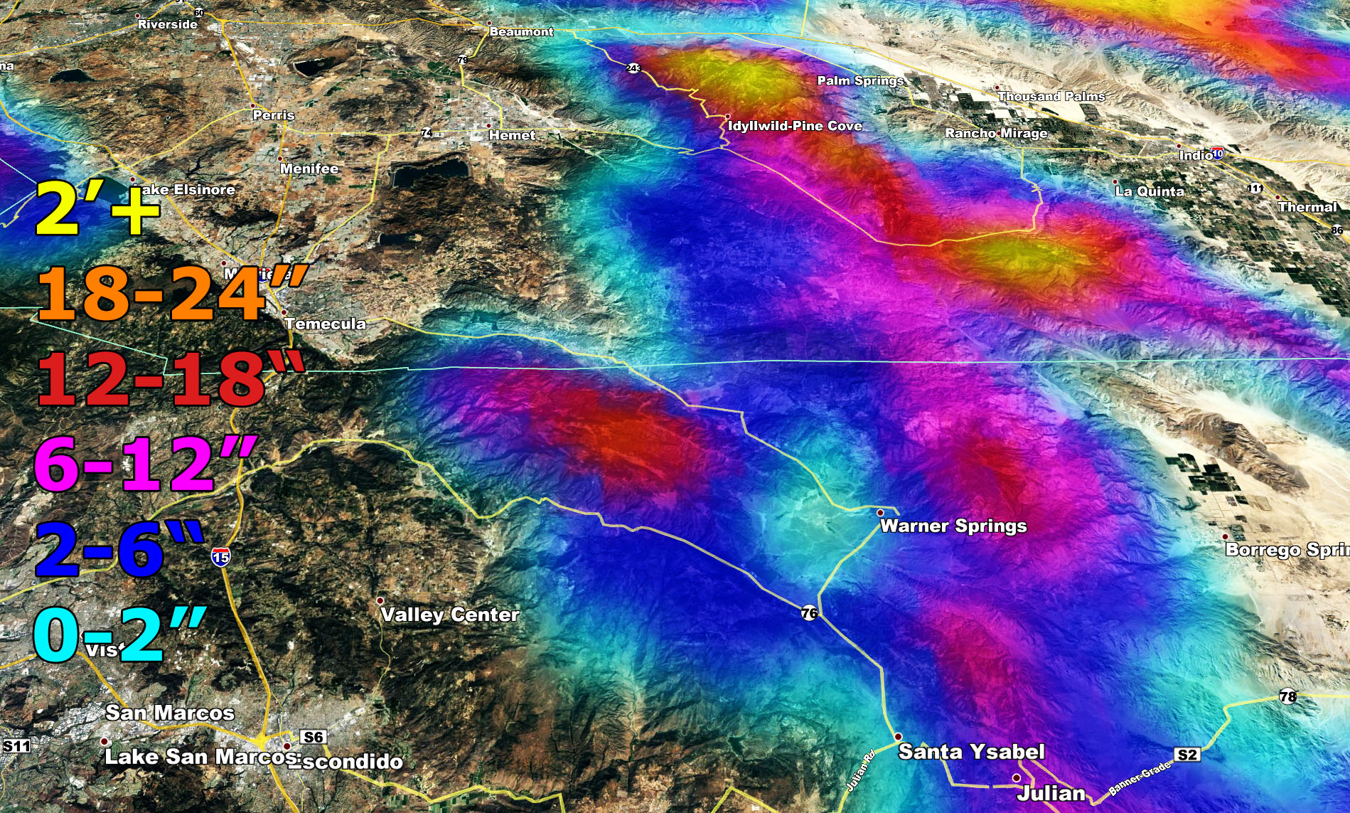
Snow is going to be the fun issue at hand. Kern County Mountains and Gorman, yesterday’s issued blizzard warning (click here) for this storm remains intact. You can read it there. The Avalanche / Winter Storm Warning (click here) for the Los Angeles and San Bernardino Mountains is also remaining intact and a lot of snow is expected.
Winter Storm Warnings remain for the Riverside and San Diego County Mountains as well.
The High Desert was issued my Winter Storm Watch (click here) yesterday morning. Furthermore I’ve updated that to my Winter Storm Warning (click here) and this includes The Cajon Pass. It will start after around 10pm tonight and pick up by the morning. If you are not over the pass by 3am you aren’t going to go over at all for awhile. This does look like a pass closing event. Some of my numbers indicate 12″ up at the top, other 6-12″… regardless.. this is a dangerous travel event and you WILL be stuck. The rest of the High Desert could see 0-2″ in spots away from the northern mountain foothill slope zones and the highest toward them so the highest of course being Lucerne Valley and Phelan.
Offshore Santa Ana Winds will be right behind it Thursday evening and night, diminishing Friday morning. They are not expected to be damaging.
As for December 30th into the 31st, the ridge buckles again and another arctic storm comes into the Western United States. How far west this gets will mean another snowy system into Southern California or a miss to the east with offshore cold Santa Ana Winds. At the current time I’d like to take it a bit east of this one as an inside slider over Las Vegas and placing better for Arizona… but we will still feel the effects from it so precipitation is in my forecast for then at the moment and if the jet is strong on the west end, we could be looking at a northwest I-5 corridor wind storm. First part of January looks dry as a large ridge moves over the area. January 2020’s forecast will be out at the end of the month.
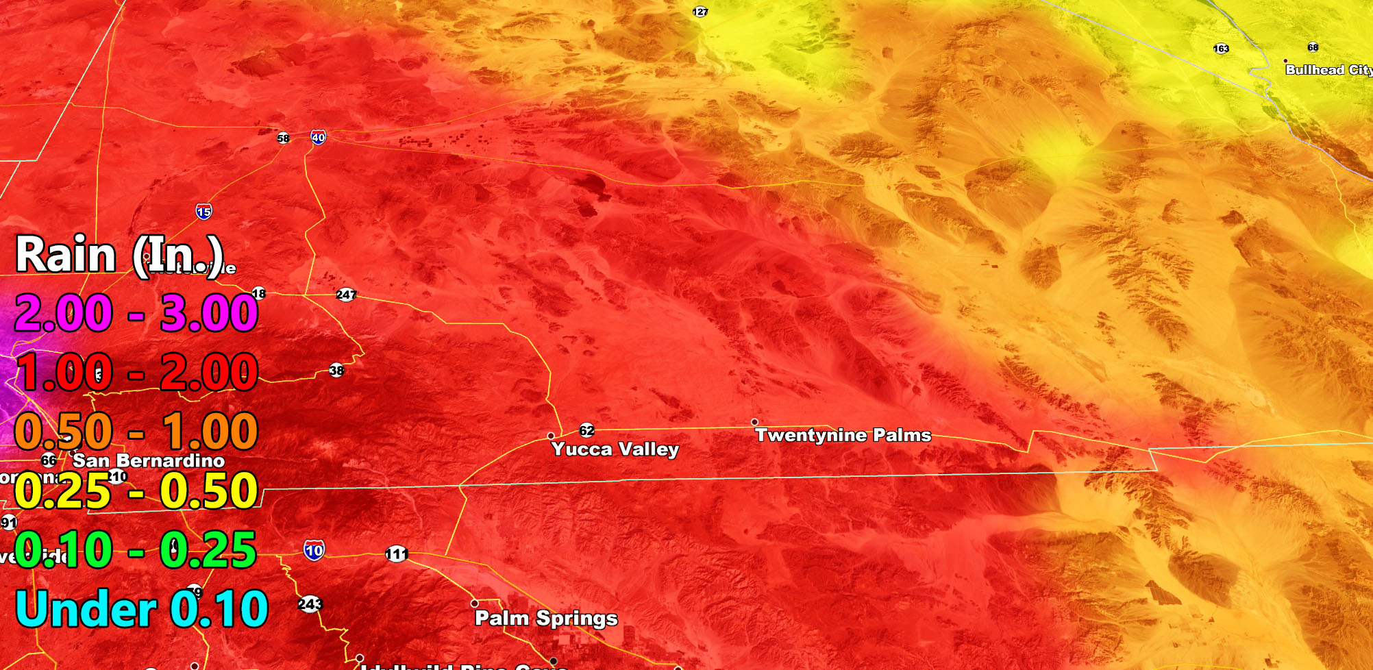
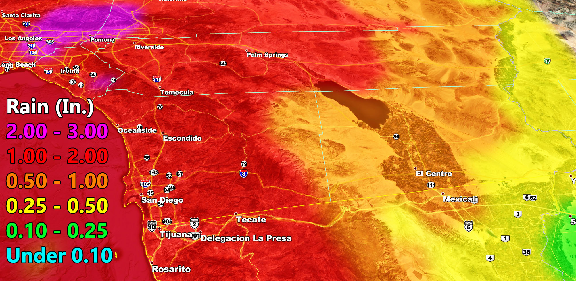
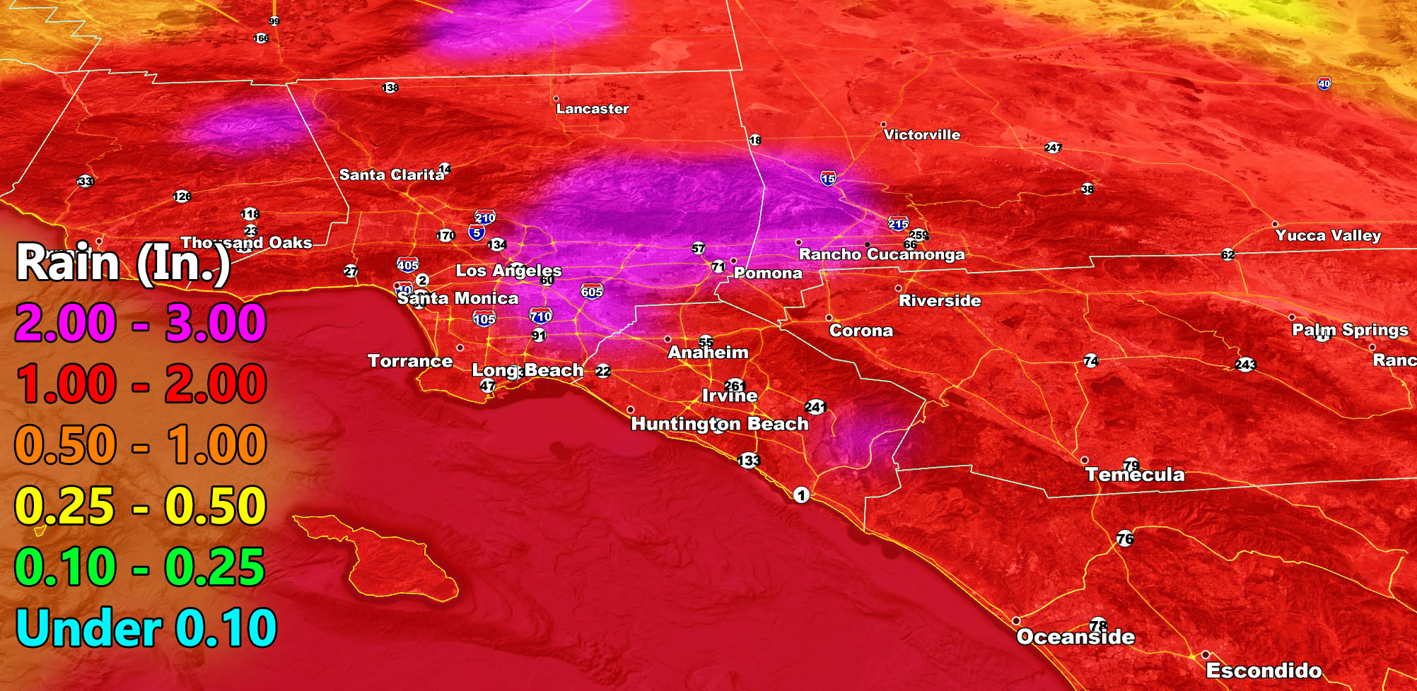
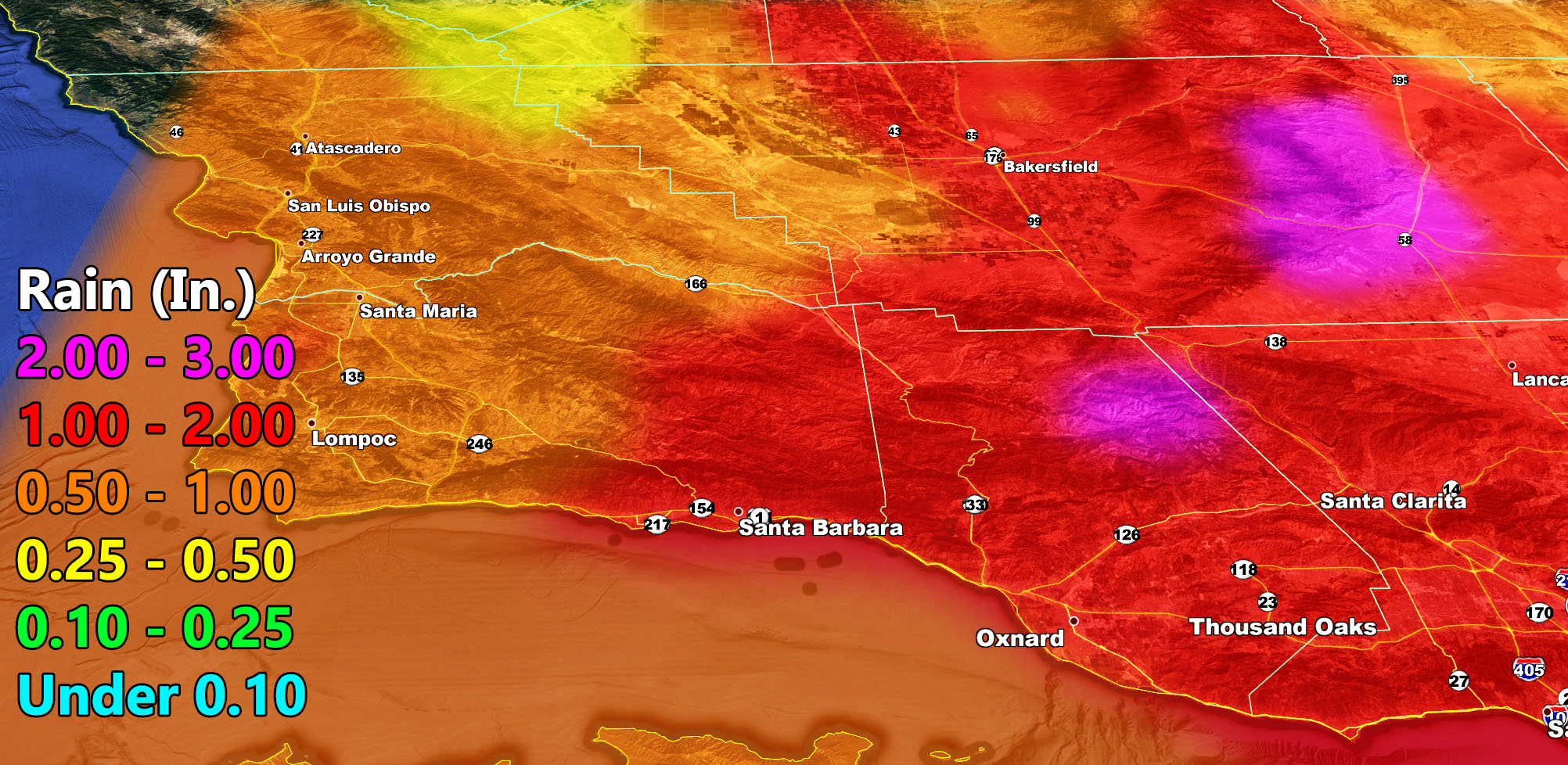
Rain Forecast for tonight through Thursday (Find your sector) – Remember this is liquid precipitation and does not include snow, you can find those in the “click here links” above in this article next to the winter storm alert products.
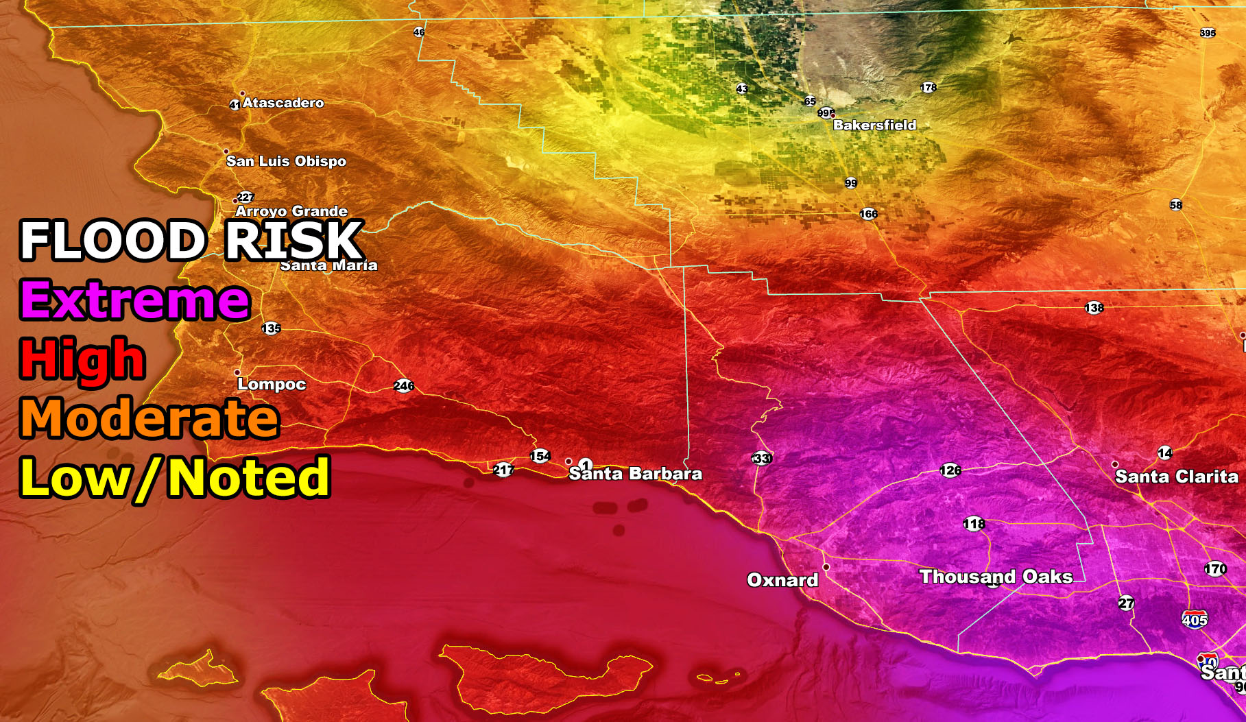
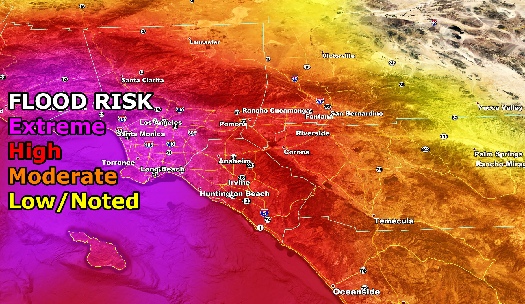
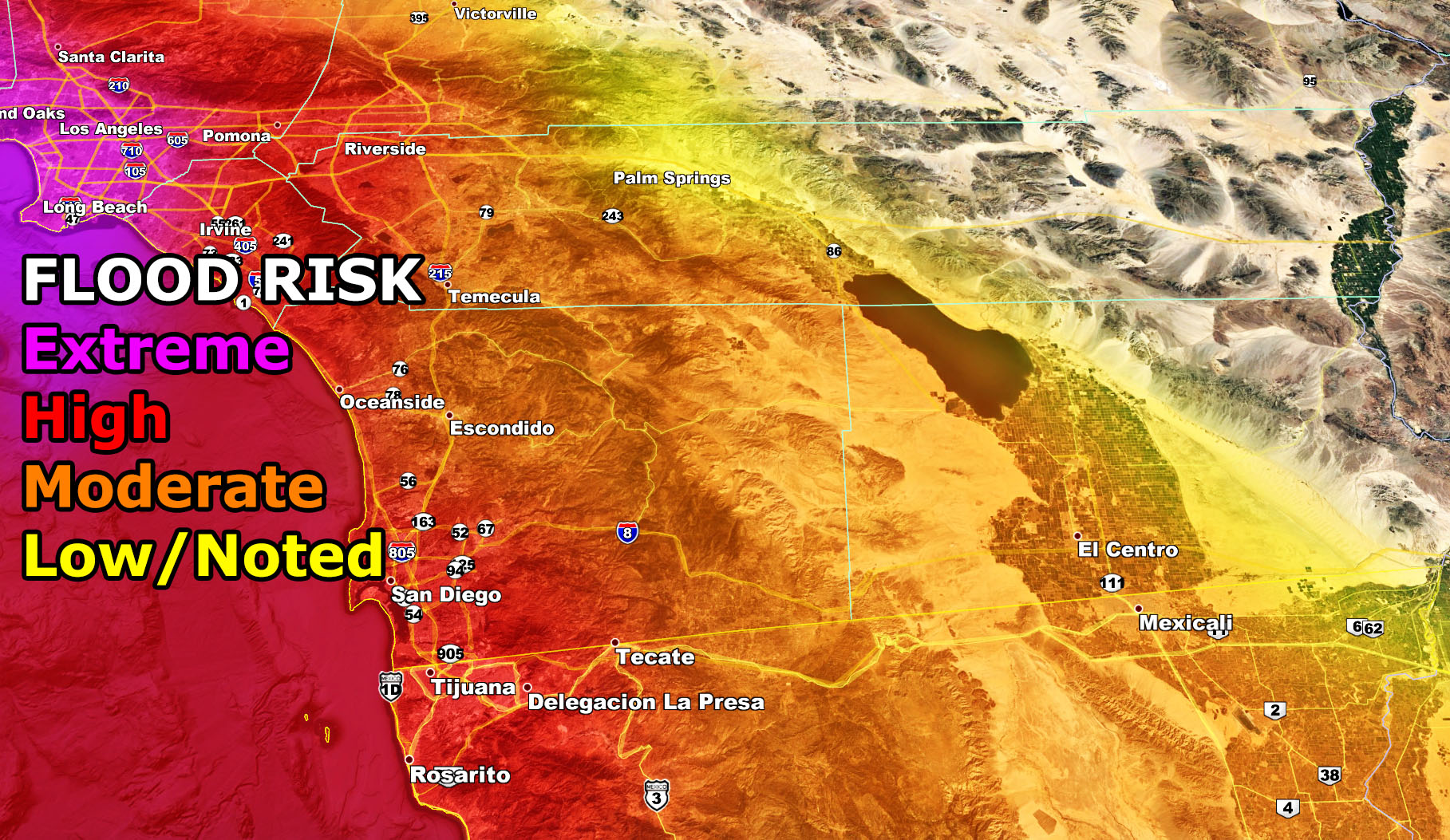
Flood Risk Model for tonight through Thursday
Snow Forecast Charts tonight through Thursday (Find your sector)


NOTE: ALL Articles AND Videos posted on Southern California Weather Force main Facebook Page are charity events. Anyone sharing will be entered into a list and one person will be randomly selected to get cash for causes. This started on in October 2019 and SCWF has donated $1883.24 to date of this article and counting. … So share away.. the more shares on Facebook, the more help can be done for the community and it costs you nothing just like a lottery ticket. October 2019’s winner was Jessica J Dominguez, and she has claimed the prize. Are you next? – Check the latest amount to win by CLICKING HERE – Remember… that number is going to climb before the contest closes!
MICRO-CLIMATE ALERT FACEBOOK GROUPS: Find yours today!
Click here to join
As always, stay tuned to official forecasts from Southern California Weather Force for updates …
For The Main Weather Facebook Page Click Here and Join.
End Article
FACEBOOK PAGES TO JOIN!
SOUTHERN CALIFORNIA WEATHER FORCE MAIN: Southern California Weather Force Office Main Page
BEHIND THE SCENES FORECASTS/UPDATE PAGE: Southern California Weather Force Meteorologist Page
FOR THE CALIFORNIA FAULT STRESS MODEL PAGE: For SCWF official updates to the California Fault Stress Model and more!
“PONDER THIS” SCIENCE ADVENTURE SHOW: A science adventure show developed here at Southern California Weather Force that is a fun ride!
INSTAGRAM AND TWITTER ACCOUNTS TO JOIN!
Instagram – https://www.instagram.com/socalweatherforce/
Twitter – https://twitter.com/SCweatherforce