
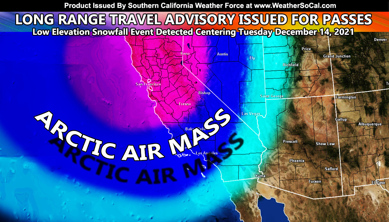
Southern California Weather Force has issued a Long Range Travel Advisory effective centering Tuesday December 14, 2021 for a low elevation snowfall risk that would impact the mountain pass and high desert areas with a snow level to 2,500 Feet as an arctic air mass bears down toward the area along with severe weather for the coastal and inland valley areas so read on for details …
In seven days from this write-up, a strong storm system looks to hit the area within the Martin Storm Pattern of December 2021. All this happening today with the light rain is just the start. This system will move due south of here and be responsible for putting a wrench into the pattern and shoving the high pressure system west toward north of Hawaii. As this happens, another system on Thursday will move in, stronger than today of course. This has been the plan all along and so far it is following what I’ve put for it. The next in line is Tuesday December 14, 2021’s system.
The system very well could obtain a Pacific Storm name, the first name given for the 2021-2022 season. Why do I name storms? Pacific Storms have been named by this service since 1999. This service is the first and only one to name them into Southern California. Naming them gives me the chance to look them up by name in my records and not by just a date. I can remember Pacific Storm Avery being September 2007 due the reason for the name. Categories are also given, from 1-6, each one higher and stronger than the other. Set parameters such as flood risks, thunderstorm risk, and wind gust risks are given to assess what category an area will be in and it is displayed on a map for all to see.
The December 14th system (or around there) is what this long range travel advisory is for. Since holiday travel is happening during that period, this needs to go out now for planning purposes. An arctic air-mass will move into the area. This is the same air-mass creating the storms in Alaska as I type this. Long range averages in my calculations continue to show this coming in as it did so last month with my December 2021 forecast, which you’ll find in the links below. This would be the system to bring the snow into the mountain pass and high desert regions. Snow levels will be as low as 2500 ft. This would affect the Gorman Pass (Grapevine), Cajon Pass, Banning Pass, and I-8 in San Diego County through Pine Valley. It also would affect the pass through Tehachapi and even Highway 14 between Santa Clarita and Palmdale.
If you do have plans to travel on that day, I would suggest continuing to monitor the latest forecasts here at Southern California Weather Force, however you get them, either by the member email alert system, social media, or checking the main website daily for updates. The ABOUT section of this site will tell you all you need to know about it for navigation. Click here to read the about section.
WANT MORE? The MAIN PAGE of this website has every alert/article issued at current. CLICK HERE TO GO
ELSEWHERE: These types of storms are the ones to produce damaging winds along the frontal zone and even the risk of tornadoes, mainly coastal and somewhat inland. Damage due to falling trees and power-lines with the winds will be likely with such a system.
LONG RANGE: With the ridge shoved west to north of Hawaii, the door remains open for storm after storm through the end of the month for the California region so stay tuned for updates …
A Martin Storm Pattern means that the pattern was predicted before apps or government/private sources, and since my last name is Martin, like a person who discovered a comet, it is only fair this coming pattern is the Martin Storm Pattern of December 2021. There will be MANY Martin Storm Patterns due to my ability to go longer range in weather.
This was a follow-up to the following articles – You can read them and see how this forecast is evolving from Day 1.
November 29, 2021
December 2021 Weather Pattern Forecast Outlook For Southern California; December Arctic Blasts and Storms
December 4, 2021
Weather Changes Coming; Martin Storm Pattern For December 2021 Begins This Week Across The Southwest United States; First Details
December 6, 2021
Martin Storm Pattern of December 2021 Starts This Week For Southern California; Atmospheric River Aiming California Week of December 13th
GPS MODELS ENABLED FOR MEMBERS: CLICK HERE FOR THE MEMBER SECTION
How to get these alerts with a premium subscription via e-mail by micro-climate zone AND/OR Get the GPS models for this event on your device enabled? (100 percent delivery time)
Click Here To Join The Season Tier
Join The Main Southern California Weather Force Facebook Group (50 percent delivery time) – You can join the main SCWF page as well through that group.
Click Here To Join The Page Today
FACEBOOK PAGES TO JOIN!
SOUTHERN CALIFORNIA WEATHER FORCE MAIN: Southern California Weather Force Office Main Page
SOUTHERN CALIFORNIA WEATHER FORCE METEOROLOGIST: – Just my public figure page that isn’t as large so maybe you can reach me better at times.
INSTAGRAM, TWITTER, TO JOIN!
Instagram – https://www.instagram.com/socalweatherforce/
Twitter – https://twitter.com/SCweatherforce
Southern California Weather Force is a custom weather alert service that began in September 1999 off and is regarded as the most accurate weather service in the region, offering custom alerts, maps, and models to help save life and property. The work done here is never 100% accurate, but it comes pretty close. Southern California Weather Force runs on zones, so if an event happens in a zone that is 10 miles from the border of your zone, the forecast is still valid to activate your zone’s alert system. A company quote to the public is that of “The Joker” and tells other agencies in weather this all the time… “This world deserves a better class of meteorologist… and I’m gonna give it to them”… out-forecasting even the National Weather Service with lead-time and precision, which makes this service a focus of ridicule and envy in the weather community due to having such accuracy. Alerts issued here are issued custom from this office and this office alone. You may not even hear it elsewhere, but if one is issued near or in your area, listen up because “if you do not wish to die in weather, follow, it’ll save your life one day.”