
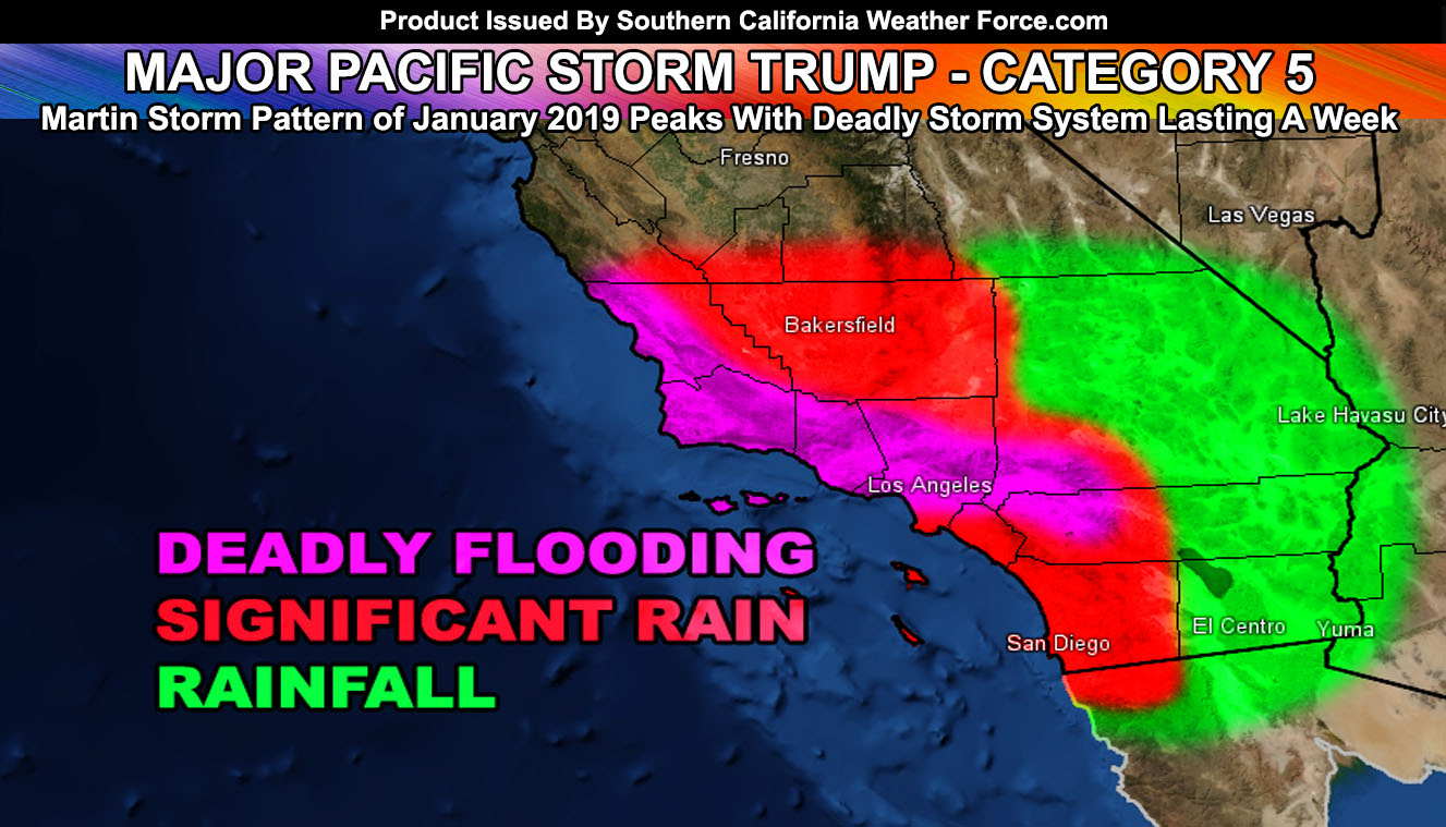
Major Pacific Storm TRUMP is official and will start as a High End Category Five System out of the 1-6 scale here at SCWF as the Martin Storm Pattern of January 2019 strengthens with the first weaker impulse arriving tonight and a deluge of deadly flooding and run-off expected most of the entire week coming up. Understand that tonight into Saturday’s first impulse is weaker and it is NOT the main event. You will be caught off guard if you think that and some of you will think this is weak and for some it will be… but it is only the beginning. Read on for details on tonight into Saturday and some detail on the following week as the burn areas are sure to give way so make your plans to get out now … This may come close to the March 1983 storm amounts around the Los Angeles area with up to 8″ or higher rainfall amounts expected and 10-15 inches in the foothills.
The first impulse is set to arrive tonight for the Santa Barbara and San Luis Obispo County areas. Flood warnings and advisories are in effect from here at Southern California Weather Force. The Flood Warning expands from Santa Barbara to Ventura County and takes the southeast flow into those areas for 1-2 inches of rainfall in a short period of time tonight. The rainfall will wait till around midnight and after for Ventura County, however with the southeast flow into the southern slopes the Flood Warning is needed. There will be a chance of isolated thunderstorms and land-falling waterspouts to small tornadoes in the warning zone. However.. most of the instability will remain offshore through the Channel Islands and the rest of the Southern California bight region with this system so that is where I think the most lightning strikes will reside.. but could strike in the LA/OC/IE/SD areas in the morning on Saturday inland. The best area within the warning zone would be Santa Barbara County for strikes tonight. Gusty winds are already being reported in the Vandenberg area and these winds will strengthen some as the front approaches.
Further southeast into Los Angeles, Orange, San Diego, and the Inland Empire between midnight and sunrise is when the southeast to northwest angled frontal zone will finally push over. The Flood Advisory is for the following areas; Western San Luis Obispo County … Western LA County, including Downtown, SCV/SFV, and Malibu … Southwest half of OC.. does not include the Santa Ana Mountains … San Diego Coast/Valley … Moderate flood risks will exist with a half inch to an inch of rainfall in spots. Some areas will see less than that due to the surface low being due west of the area and bringing in somewhat of an ‘offshore pattern’ that can and does often dry some low level atmospheric profiles out so this advisory will largely depend if you are in that zone.
I do know that the LA/OC part of the advisory will be correct and so will Downtown San Diego… I’m iffy on Vista/Oceanside where a quarter of an inch could fall with offshore flow present.
This will move out over Saturday afternoon as the impulse heads off into the High and Low Deserts …
Instead of a winter weather advisory I really felt to just keep it a ‘short term forecast‘ for the Kern, Los Angeles, San Bernardino and Riverside Mountains above 5,000 FT. A fast moving system will move through the region tonight into Saturday, bringing a bit of snowfall above 5,000 FT to the short term forecast zone. There are concerns with somewhat of an ‘offshore’ flow into the system with the surface low being in the bight region. These concerns would limit snowfall amounts and thus I really do not want to go anymore than 3 inches around Big Bear and Frazier and really just put a dusting to 2″ as an average for the populated mountain communities with this system with isolated spots of a bit more. Will look into it again after 8pm tonight and make the final decision to upgrade to advisory or keep it at that with the new and final snow model data updating on the member section.
DESERTS: This is an upper level dynamic system with deep-layer moisture and not much southerly flow. These types of systems bring adequate rainfall to the high and low desert areas and not needing of being near a mountain nor will most mountains block any moisture. So I am expecting rain in ALL High and Low Desert areas, including Ridgecrest and Barstow.
RAMS/COWBOYS GAME: Expecting the precipitation to move out before the game starts. That also includes motocross in Anaheim.
MEDIUM RANGE NEXT WEEK: A number of large impulses circling Major Pacific Storm TRUMP will move into the region starting Monday. That will be the first one. The second one is Tuesday and lasting into some of Wednesday in spots and the final one on Thursday. Major Pacific Storm TRUMP will move inland then and we will dry out.
SNOW: Because these upper systems are so far south with a tropical fetch.. 6,000 FT snow levels beginning week going up through 7,000 FT is most likely. There is a chance that most mountain communities will have rain and non-sticking snow rather than a full blown blizzard. I will monitor it carefully but if that is the case I will issue flood products for the mountain areas as time permits.
I will be working extremely hard here at Southern California Weather Force as each impulse approaches. My numbers show a difference in timing and strength on the Thursday impulse, however I will go with the stronger numbers at the moment. This is a dangerous storm system and it likely will be the strongest single multiple storm complex in over 30 years.
NOTE: I will be working hard on this and yes.. members you will get your updates in a timely manner. However I have a medical issue I am working on and you can read that by clicking here. I will however try to be as timely as possible and rest in-between systems as much as I could.
PREMIUM MEMBERS: Rain/Snow
End
NOTE: Premium members. If you are signed up, your login is your e-mail address and the username and password as the password. You can change the password
Ongoing Ad – The Southern California Weather Force has a member section with LIVE UPDATES FOR EVENTS and rain, wind, thunder, tornado etc models that are personally updated by me with each Santa Ana Wind or storm event. You also can get e-mailed alerts via a slew of micro-climates. Check the member section for details on how you can support this service.. along with getting service in return… Click Here To Join or Upgrade Via The Member Section
Please remember if upgrading to CANCEL YOUR PAYPAL PAYMENTS. Login and cancel the reoccurring payments.
The Southern California Weather Force has different Facebook groups that you can ask for notifications from in order to get the latest posts affecting those regions. If that area is talked about in an article, alert, and such .. it’ll be posted there and you can be notified.
Comments are usually DISABLED as we do like to keep this as an information giving group and replies from others in the notification may annoy some.
Find your micro-climate group here – https://www.southerncaliforniaweatherforce.com/scwf-weather-alert-facebook-groups-by-region/
EMAIL ALERTS? Many micro-climate zones to choose from to get custom alerts from thunderstorm, wind, flood, surf, heat, cold, storm, and much more with the premium e-mail alert system, the most advanced zone alert system in Southern California – Click Here To Join!
SOUTHERN CALIFORNIA ONLY: if it does not say “Liked” LIKE The Page Below and join thousands of informed weather forecast viewers in our region for more of the updates! noticeable
BEHIND THE SCENES FORECASTS/UPDATE PAGE: if it does not say “Liked” LIKE The Page Below and join thousands of informed weather forecast viewers in our region for more of the updates! noticeable