
A major pacific storm is projected to impact Southern California on Monday, March 28, 2022. In a pattern I have been following since March 18th, we are now on the final leg of the forecast for flood, rain, snow, and wind gusts so to get an entire breakdown of focus spots in a new designed outline write-up for Morning, Afternoon, Evening, and Overnight along with the custom SCWF models in what will be the most complex forecast written … read on for details …
Join the Facebook Page for Further Updates If You Have Not Yet! Lots of discussion and information there for this and future events … and yes, I even reply back to questions most of the time if I have the time!
SOUTHERN CALIFORNIA WEATHER FORCE MAIN:
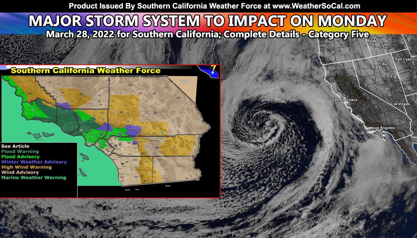
The major pacific storm is a category five out of the six-category scale here at Southern California Weather Force. That means it means business and if people are not aware of their surrounding in a higher impact area like floods and thunderstorms… their life could end this way. So, those of you that have and do follow Southern California Weather Force‘s outline and models, you will never be caught off guard so as long as I am still alive. So with that, let’s get on with the forecast outline.
MONDAY MORNING: The first front will move into San Luis Obispo and Vandenberg Space Force Base by 2am, which will greet the forecast area at the earliest time. It will move eastward with gusty winds along the squall-line into Santa Barbara by the 5-6am hour. As that is happening, southerly upslope flow will create hit and miss showers well ahead of the front for areas like OC/LA and Ventura County. Thunderstorm dynamics with the first front is often rare, but my numbers do indicate this being possible and will develop in the Santa Barbara forecast zone around this time. As the sun rises, the front will cross into Ventura by 7-8am and continue the assault with flooding. Thunderstorm dynamics are also in play still and growing with time, especially in the areas Ojai northward where upsloping occurs with the orographic lifting. We still have hit and miss showers for OC/LA at this time and even some on the San Diego Coast. The front will hit Downtown Los Angeles by around 10-11am with continued heavy rain and gusty winds in a squalline factor. I will say right now this front does have thunderstorm + low-level shear dynamics with it. If it is strong enough with the instability at the surface, I cannot rule out embedded waterspouts to small tornadoes with it anywhere from Santa Barbara, Ventura, or Los Angeles Counties.
MONDAY AFTERNOON: The first front having exited the Los Angeles areas will hit the Central Orange County zones as showers get stronger in the Northern Inland Empire. Given the low-level wind values, this front will still look like a squall-line on radar as it blasts through Riverside by 1pm and San Diego by 2pm. As that is happening, cold air aloft will move in behind it and the heating of the day will shoot off stronger thunderstorm cells across San Luis Obispo, Santa Barbara, and Ventura County with the secondary impulse moving in behind the first one, gaining strength in all areas through the entire afternoon. There is an interesting component in the Kern Valley areas, probably near or south of Bakersfield along the I-5 zones around 4-5pm. It is a southeast surface flow with strong instability from a high Sun angle and this means there is a chance of a cell that can produce a tornado. They do sometimes happen in that valley so it is always possible. Moving to outside of Southern California, around 3-4pm the upper lift finally reaches state-line at the CA/NV border along I-15 and this will start the chance of thunderstorms in the Las Vegas forecast zones, which is an outside jurisdiction of the Southern California Weather Force systems.
MONDAY EVENING: Monday evening will go from 6pm till 10pm and then we talk about the overnight. By 6pm, the secondary impulse will be covering all of Los Angeles with storm cells everywhere. The entire basin will be covered a thunder will continue to be reported. Instability is high enough to warrant larger hail and there is some low-level shear to keep tornado chances in the forecast. I do not mean waterspouts only, over the land tornadoes developing. This batch moves eastward through Orange County by 6-7pm and then into the entire Inland Empire zones by 7-8pm, including San Diego County. I think even the Coachella Valley will get in on the rainfall with this one since it has deeper-layer moisture and that will happen between 9-10pm.
While the storms are in the Inland Empire, the third impulse will be crossing Santa Barbara and Ventura, bringing another upswing in thunderstorm activity there.
MONDAY OVERNIGHT: Starting at 10pm as the Coachella Valley batch continues there, we start to turn to off and on thunderstorms, meaning pop up here and there with no real focus. It will move through to the east pretty quickly, but yet another round of storms is expected for LA/OC/IE with isolated (less) activity for San Diego. This continues all night and by sunrise Tuesday morning everything is moving off with more stable air in, ending a night not many will soon forget.
THUNDERSTORM WATCHES: I will continue to monitor the area through this afternoon and the first watch will go out this evening should trends continue. This watch will cover the first, second, and third impulses all together with another discussion.
DIDN’T TALK ABOUT YOUR AREA?: Use the model images below to get an idea what to expect with this system.
OFFICIAL CURRENT issued Southern California Weather Force Alerts by location at time of post release –
Thunderstorm Watches: PENDING
Flood Warning: Santa Barbara Coast/Mountains … Ventura County … Los Angeles County Malibu, SFV/SCV including Magic Mountain, and Mountains near Acton and Mt. Wilson …
Flood Advisory: San Luis Obispo Coast … Los Angeles Basin and LAX/Santa Monica … Orange County Basin Central/North including Disneyland and Knotts … Northern Inland Empire Ontario through Yucaipa and into Moreno Valley/Banning …
Winter Weather Advisory: San Bernardino Mountains Green Valley Lake, Big Bear, and Onyx Summit … Los Angeles Mountains including Mt. High Ski Resort and Wrightwood … Cuddy Valley including Pine Mountain Club …
High Wind Warning: Inner San Luis Obispo County … Kern Valley near and southeast of Bakersfield … Gorman Pass … Antelope Valley … Metro High Desert Victor and Lucerne Valley including Barstow … Morongo Basin … Coachella Valley … San Diego Mountain and Desert: Ocotillo … Desert Center … Kern Tehachapi …
Wind Advisory: Kern Valleys and Deserts … Needles/Baker … Joshua Tree National Park … Imperial County …
Marine Weather Warning: All bight (Island Regions) …
WANT MORE? The MAIN PAGE of this website has every alert/article issued at current. CLICK HERE TO GO
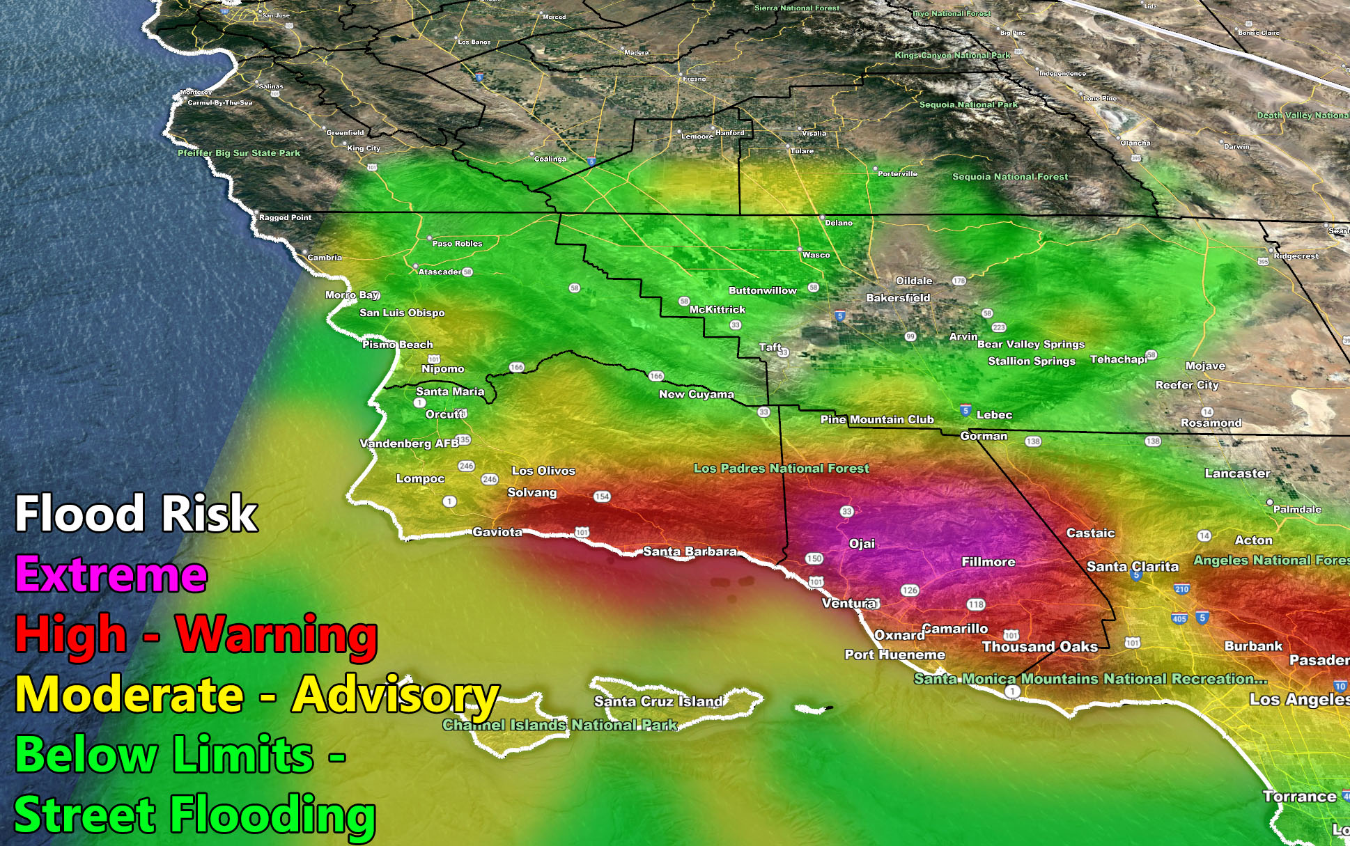
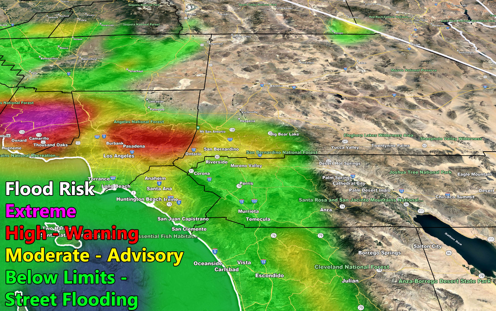
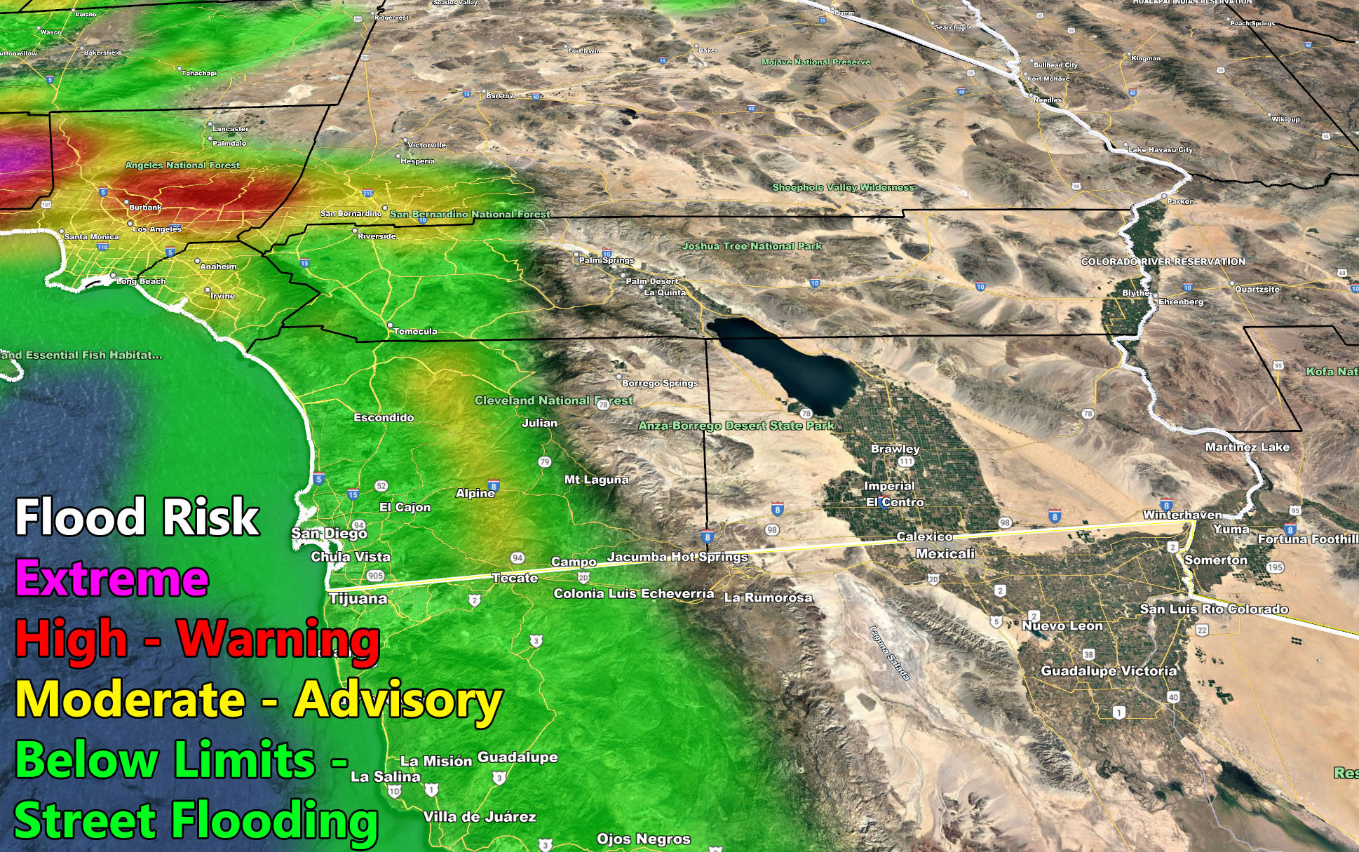
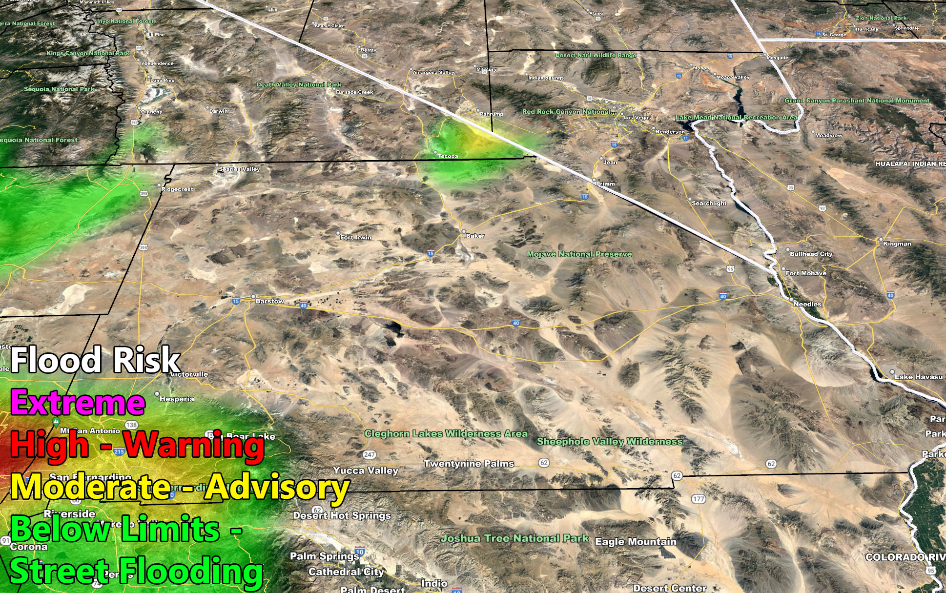
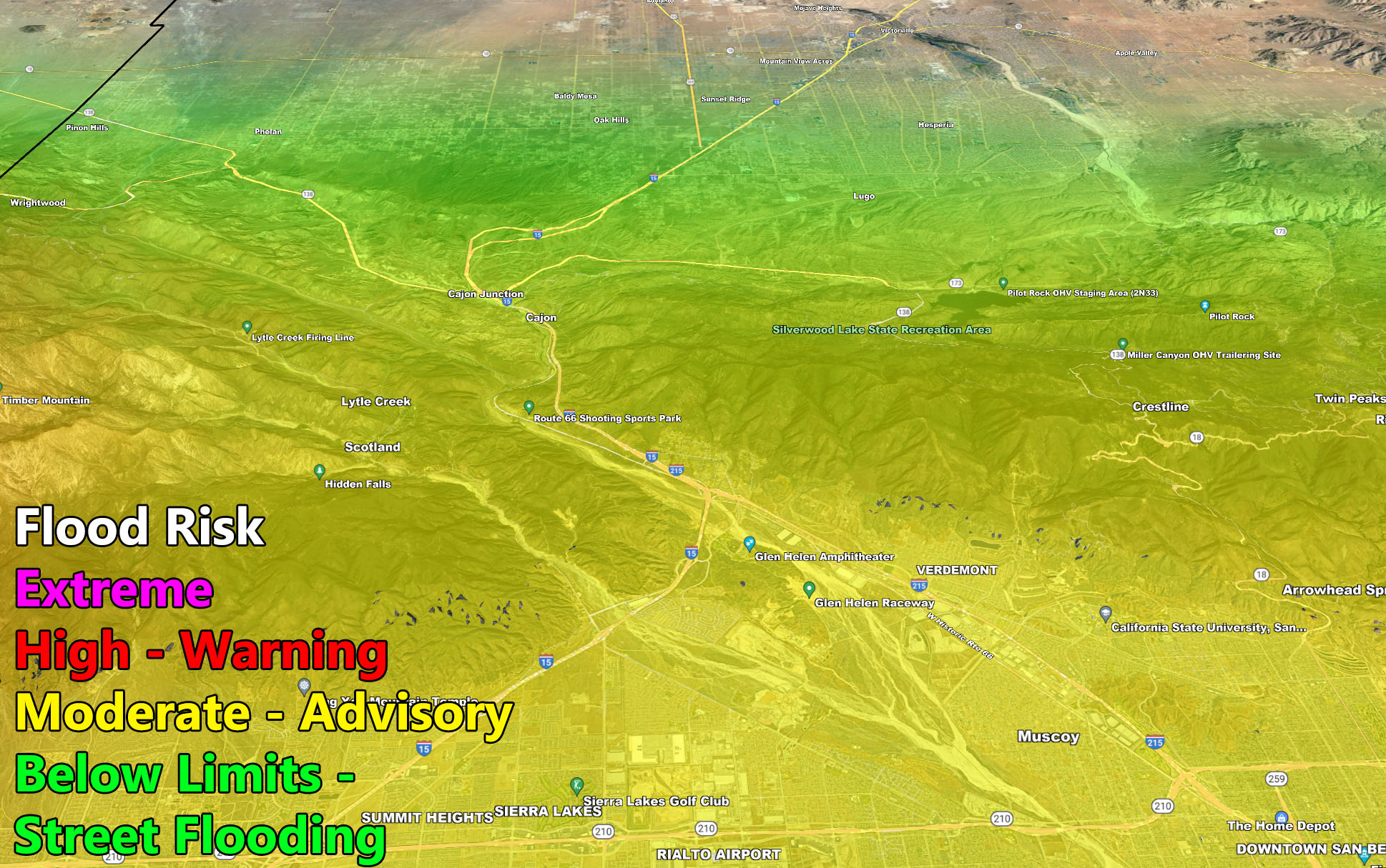
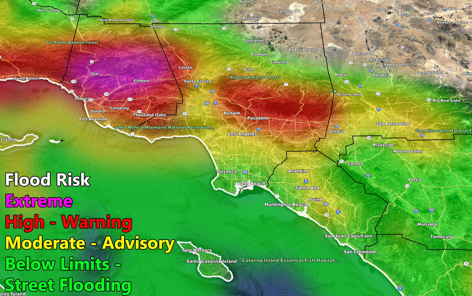
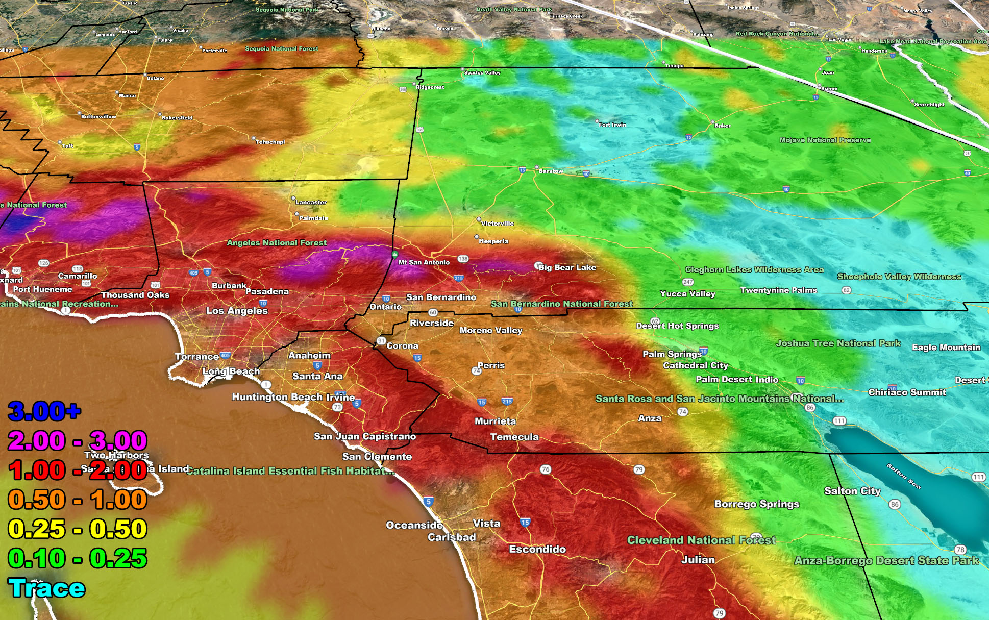
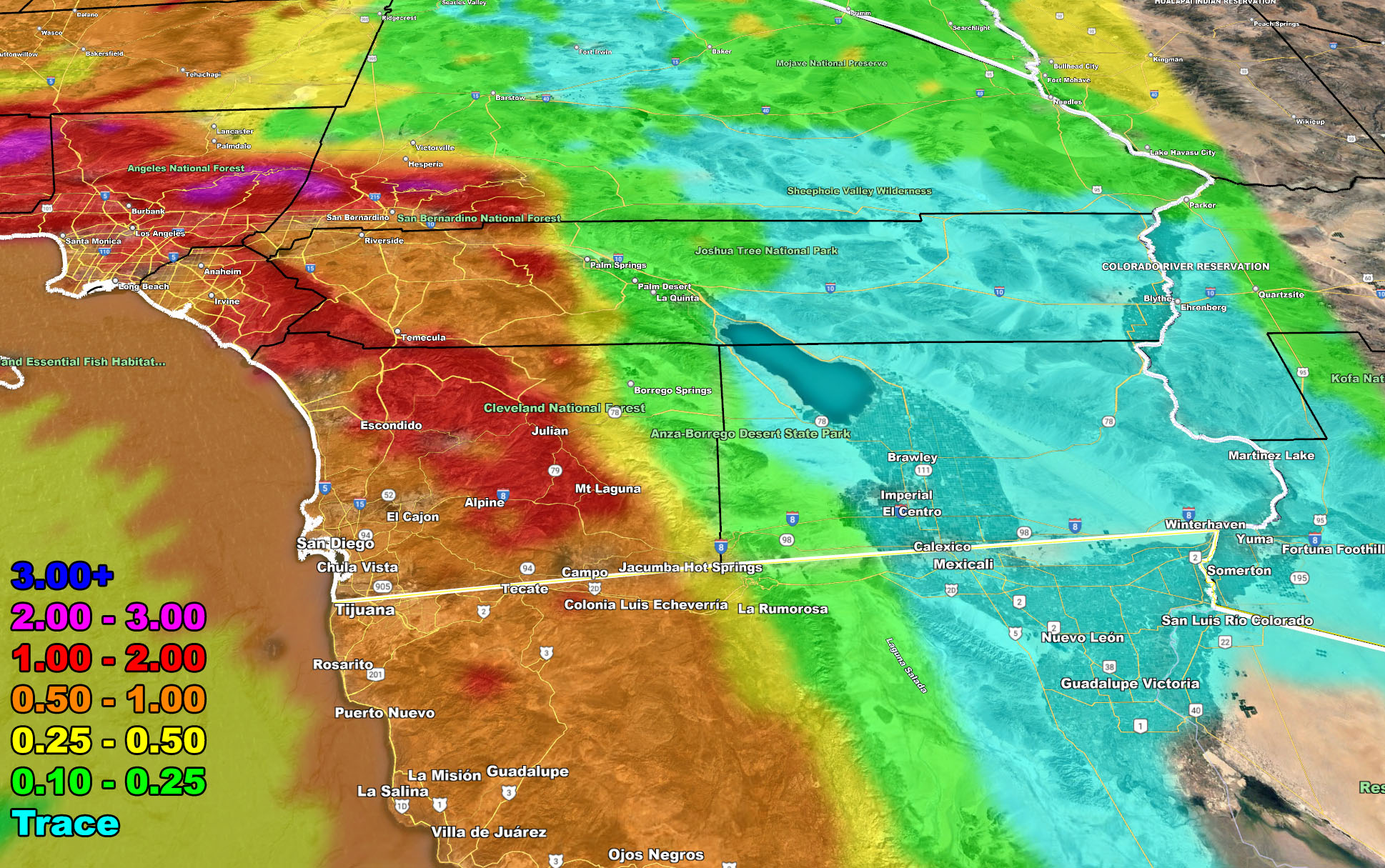
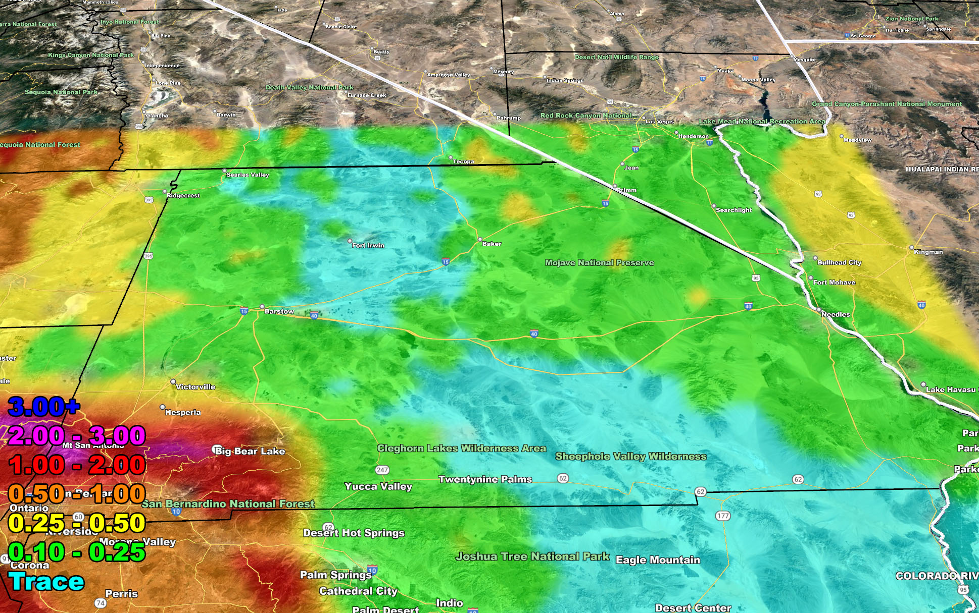
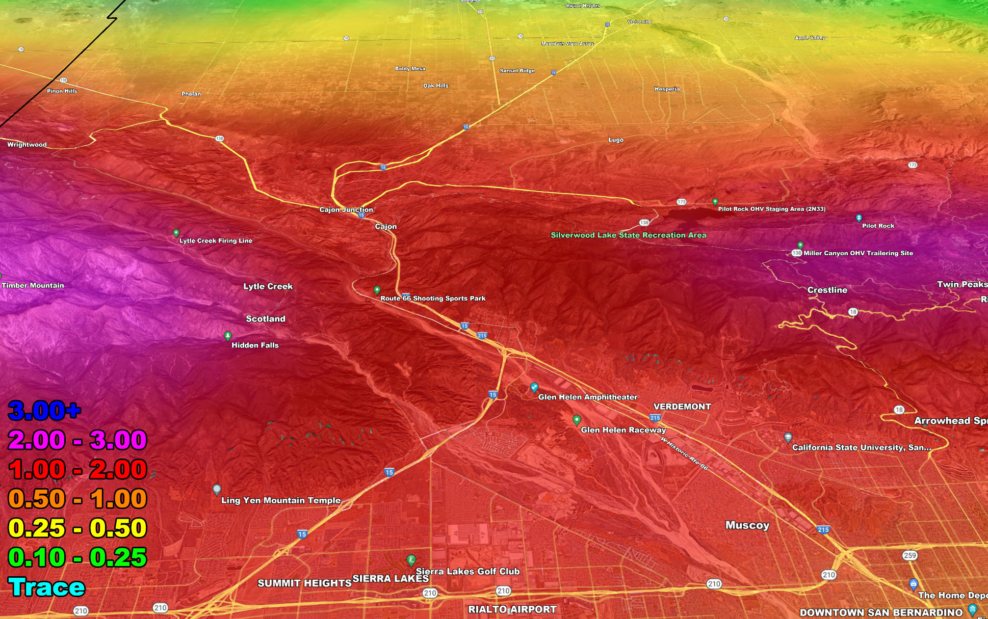
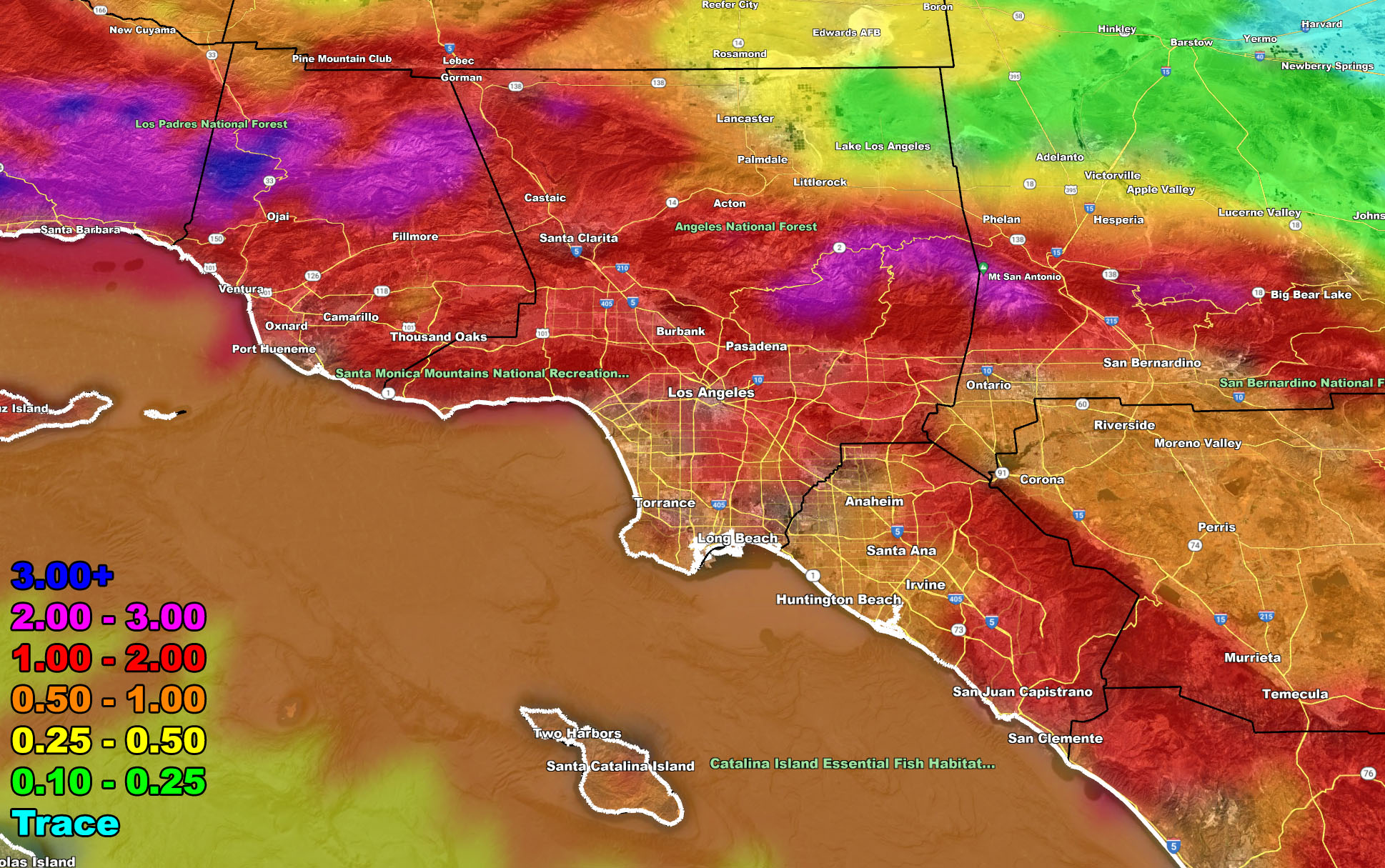
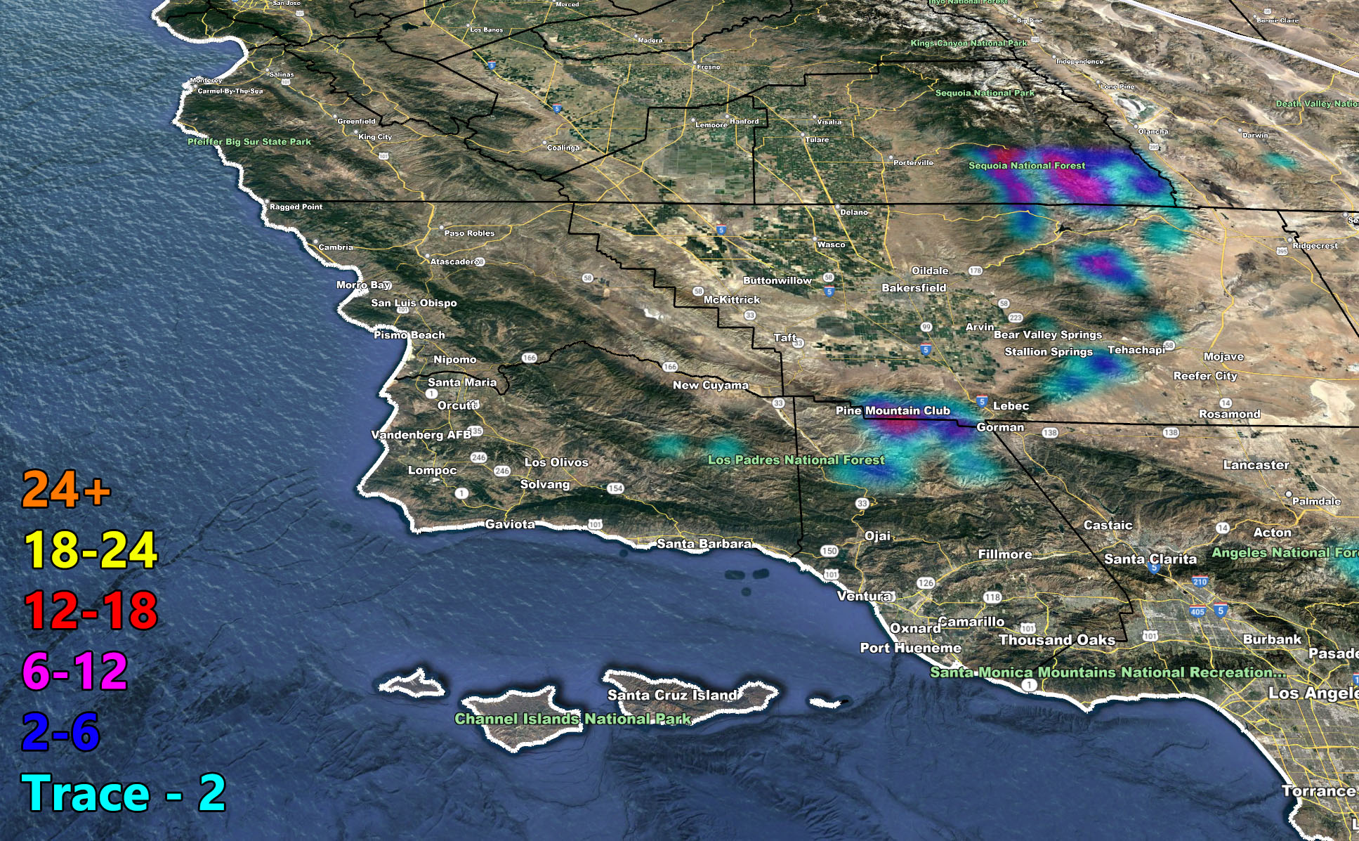
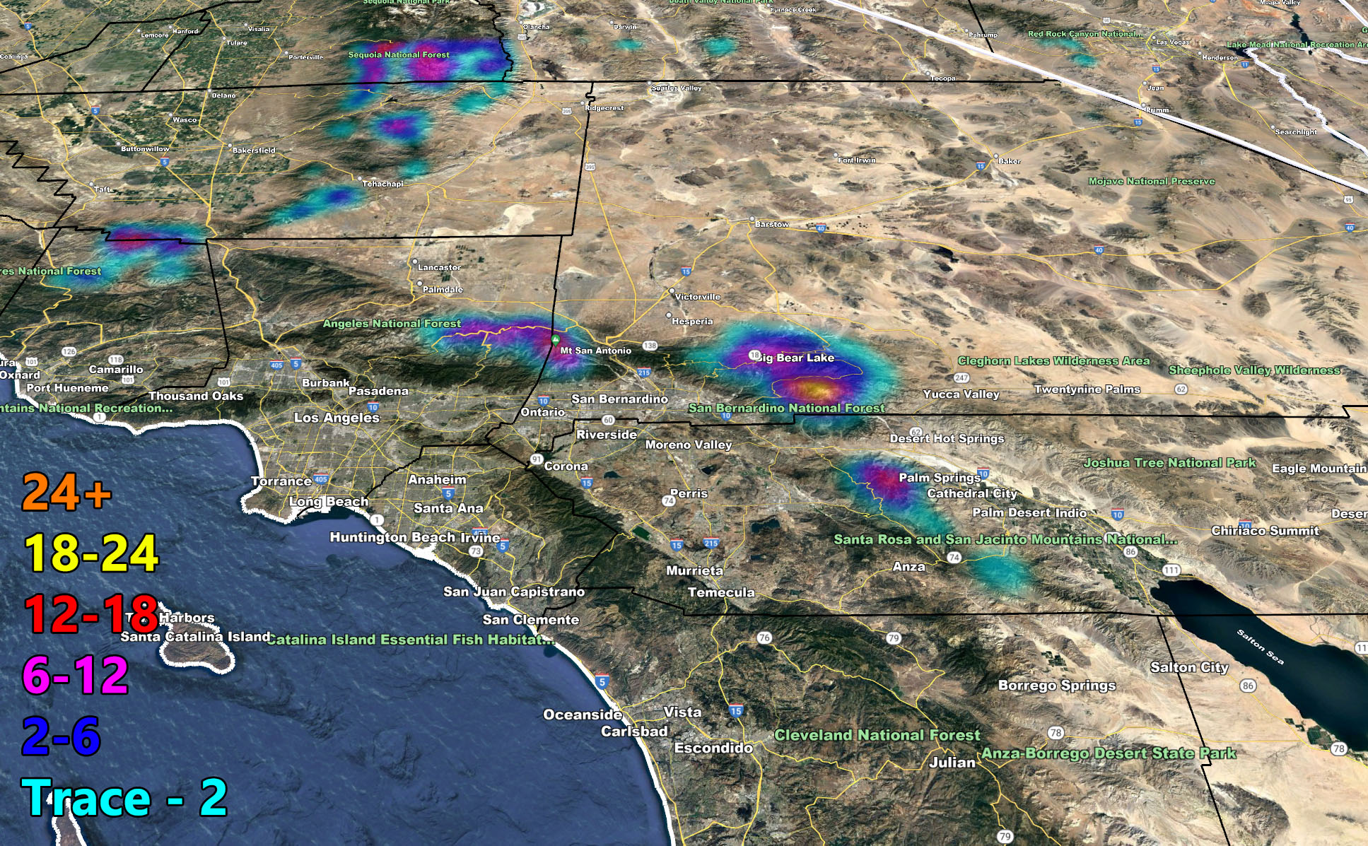
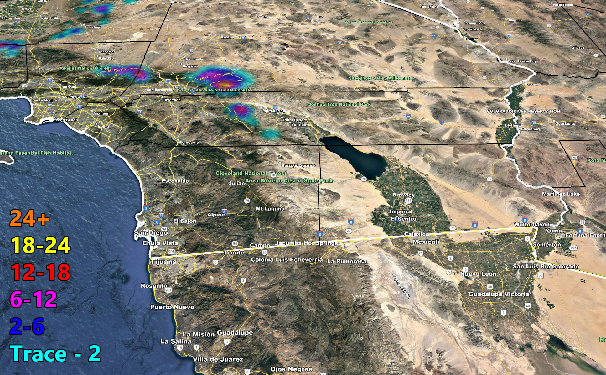
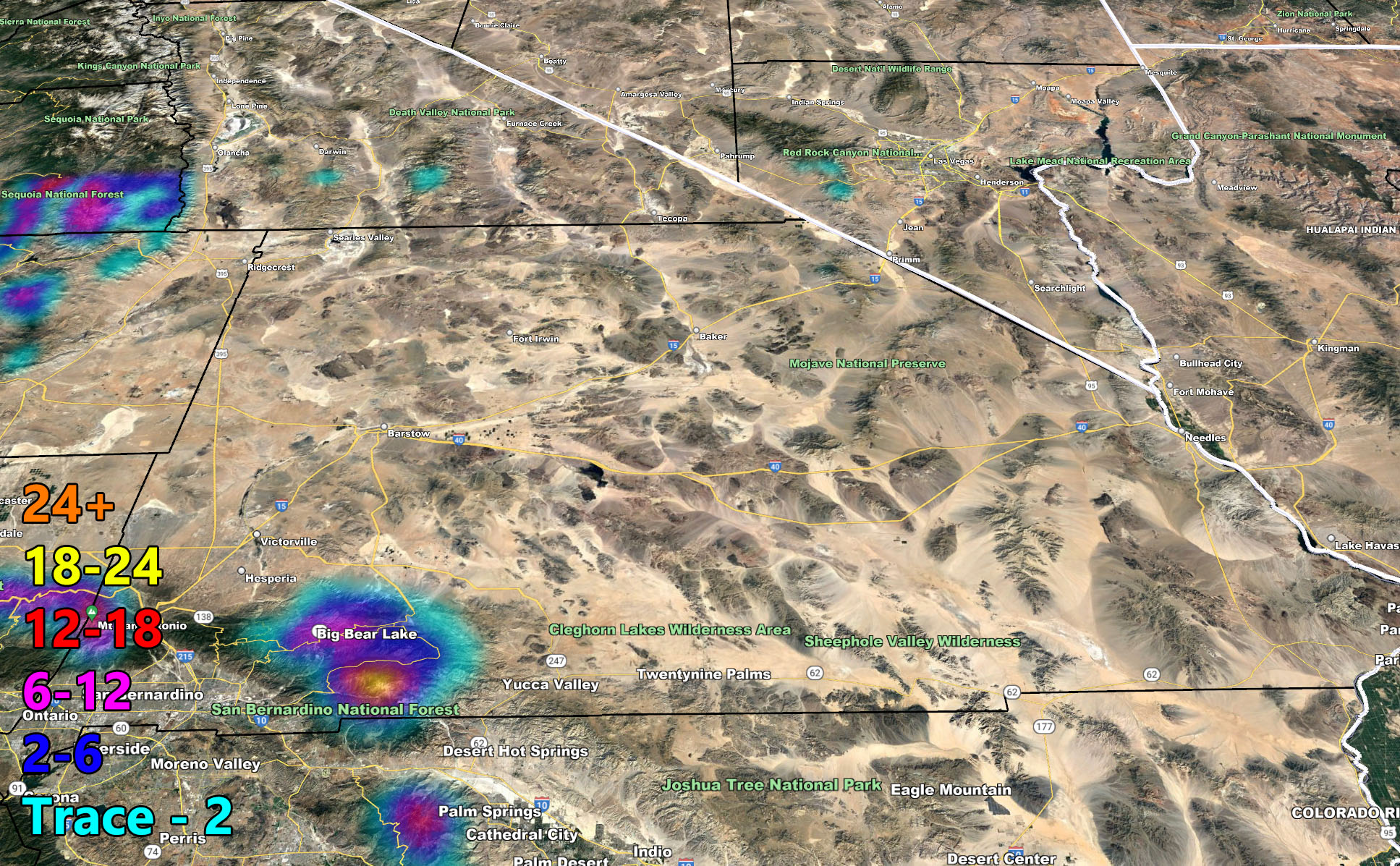
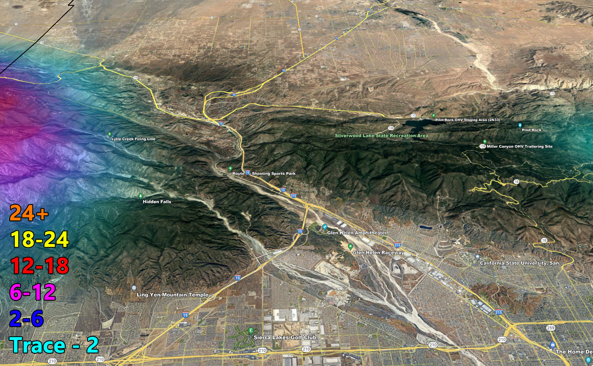
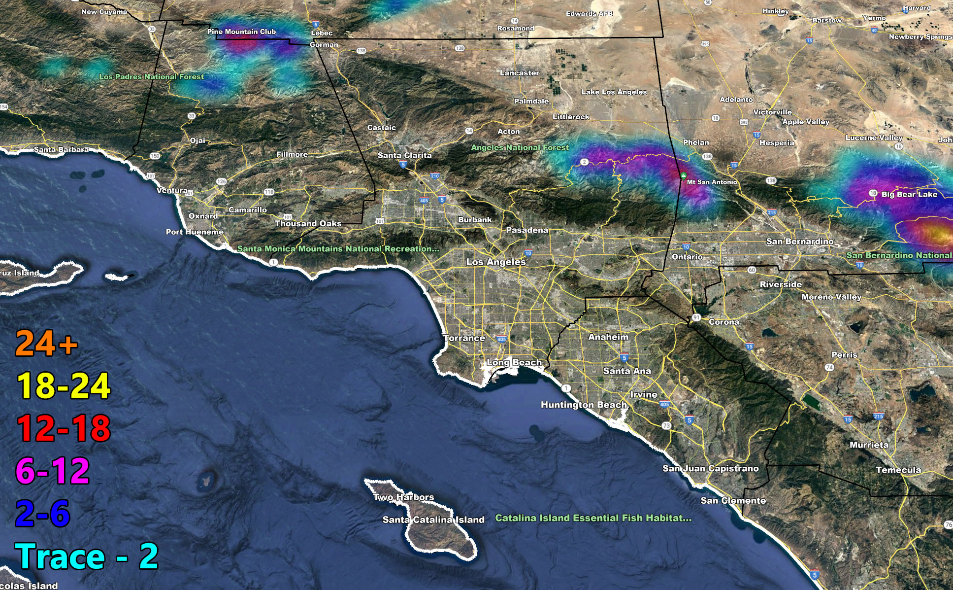
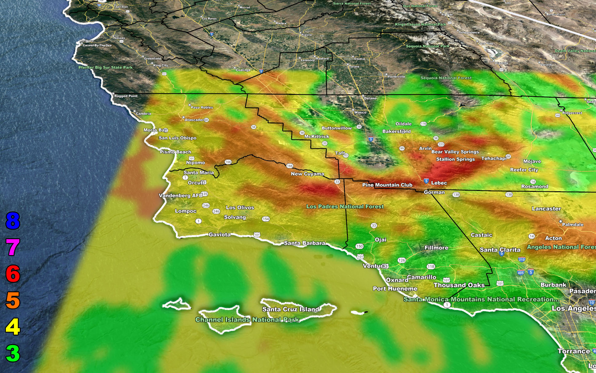
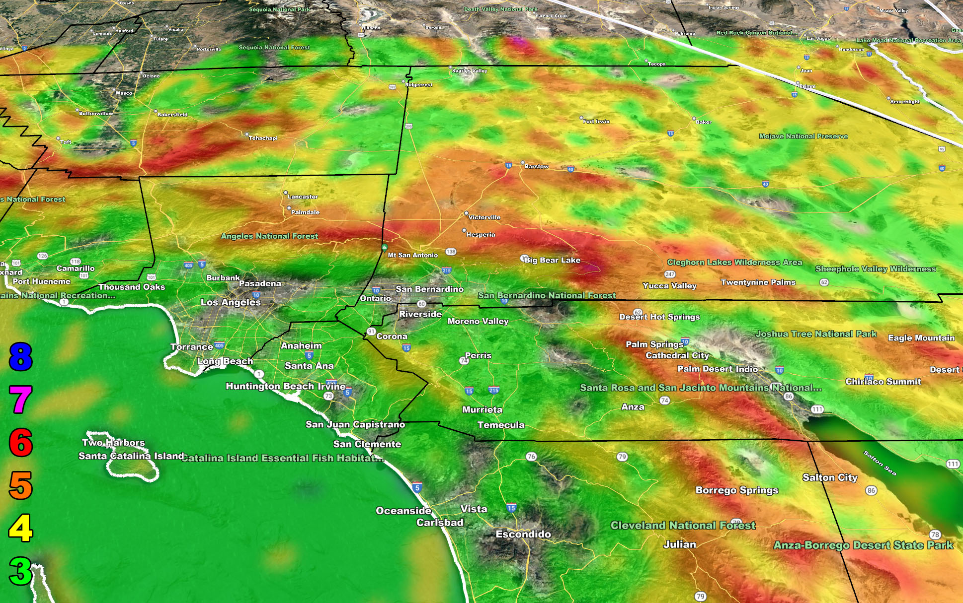
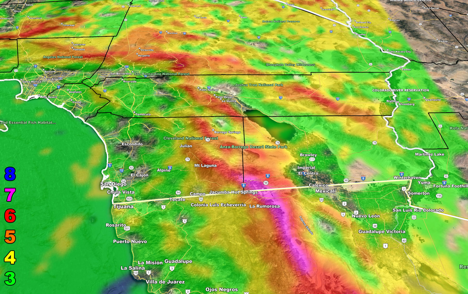
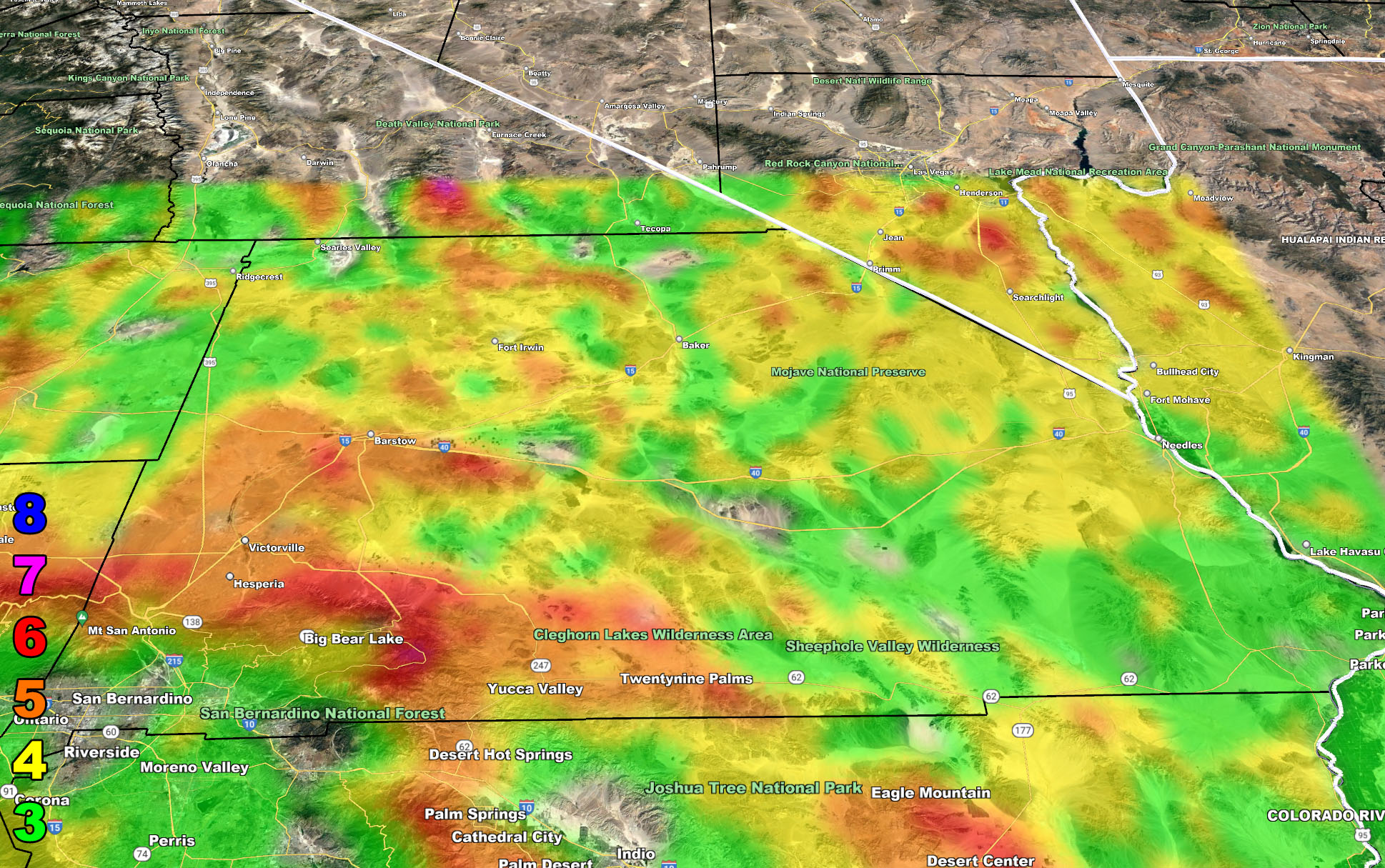
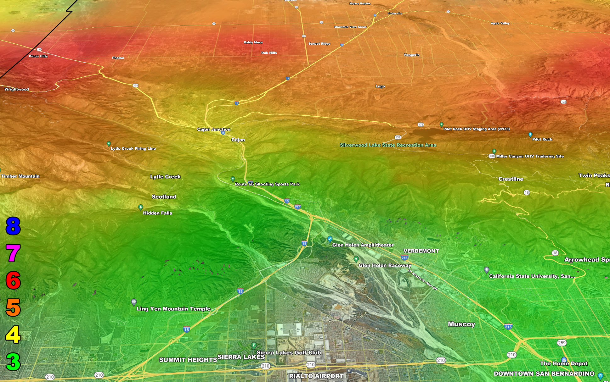
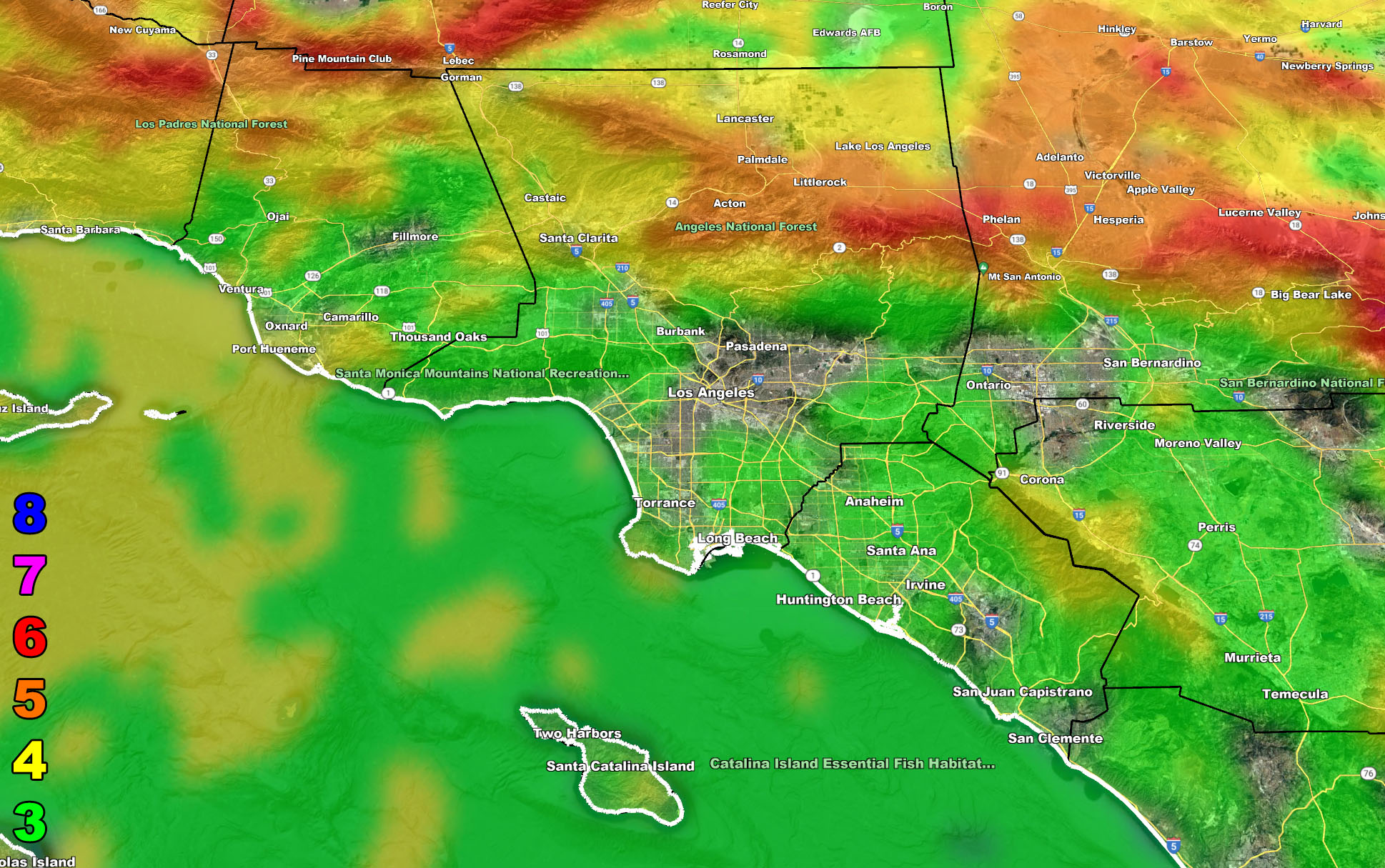
There are 10 counties in the Southern California Weather Force forecast area and I cannot write about each micro-climate sector in this article. I however can show you the images in the SCWF model suite and you will need to know where you are on a map to read them. Everyone should know where they are on a map so this is no excuse.
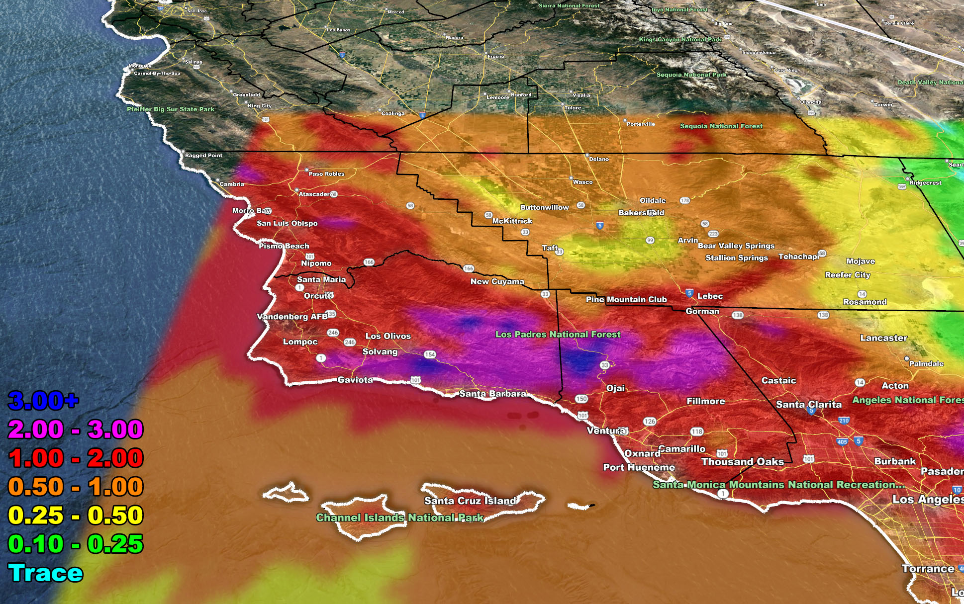
The maps below are of flood, rain, snow, snow-level, or wind intensity, whichever is available now. Each one is clickable. Map 1 is NW SoCal, Map 2 is SW SoCal, Map 3 is SE SoCal, Map 4 is NE SoCal, Map 5 is the Cajon Pass, and Map 6 is the metro areas of VT/LA/OC/IE …
GET TO KNOW YOUR MAP BECAUSE THESE NEVER CHANGE LOCATIONS
Flood Risk Forecast – Valid Monday March 28, 2022
GPS MODELS – (SCWF Members Click Here For The GPS Version)
Rain Forecast – Valid Monday March 28, 2022
GPS MODELS – (SCWF Members Click Here For The GPS Version)
Snow Forecast – Valid Monday March 28, 2022
GPS MODELS – (SCWF Members Click Here For The GPS Version)
Wind Forecast – Valid Monday March 28, 2022
GPS MODELS – (SCWF Members Click Here For The GPS Version)
Martin Wind Gust Intensity Scale –
8. Extensive widespread damage.
7. Trees are broken or uprooted, building damage is considerable. – High Profile Vehicle Roll-Over CERTAIN.
6. SOME Trees are broken or uprooted, building damage is possible. – High Profile Vehicle Roll-Over Likely, Do NOT recommend Traveling in this zone. This zone also is the starting zone where trees and powerlines will fall and damage cars and even kill people near or in them!
5. Slight damage occurs to buildings, shingles are blown off of roofs. HIGH WIND WARNING CRITERIA – High Profile Vehicle Roll-Over Possible if weight is not corrected.
4. Twigs and small branches are broken from trees, walking is difficult. This criteria and higher is where blowing dust will happen in areas where it is not raining and hasn’t for a while.
3. Large trees sway, becoming difficult to walk. POWER SHUTDOWN THRESHOLD DURING FIRE WEATHER / WIND ADVISORY CRITERIA
The following articles pertained to the analysis and prediction of this forecast …
March 18, 2022 – The initial prediction for the date in the long range section
FINAL FORECAST: Cold Inside Slider To Move Through Southern California This Weekend; Rain, Snow, Wind Models; Hit and Miss Expected
March 24, 2022 – The Thunderstorm wording Along With Issuing a Category Four
Strong Storm System Eyes Southern California Monday; Possibly Major Pacific Storm Status; Second Outlook
March 25, 2022 – The Official Flood Watch Issued
Flood Watch
March 25, 2022 – Numerous Thunderstorms Projected
Numerous Thunderstorms Certain To Hit Southern California Metros On Monday March 28, 2022; Flood Watch Issued
March 26, 2022 – Storm Upgraded To Category Five
Major Storm For Monday Upgraded To Category Five; Main Threat Will Be Thunderstorms For Southern California
How to get these alerts with a premium subscription via e-mail by micro-climate zone AND/OR Get the GPS models for this event on your device enabled? (100 percent delivery time)
Click Here To Join The Season Tier
Join The Main Southern California Weather Force Facebook Group (50 percent delivery time) – You can join the main SCWF page as well through that group.
Click Here To Join The Page Today
FACEBOOK PAGES TO JOIN!
SOUTHERN CALIFORNIA WEATHER FORCE MAIN: Southern California Weather Force Office Main Page
SOUTHERN CALIFORNIA WEATHER FORCE METEOROLOGIST: – Just my public figure page that isn’t as large so maybe you can reach me better at times.
INSTAGRAM, TWITTER, TO JOIN!
Instagram – https://www.instagram.com/socalweatherforce/
Twitter – https://twitter.com/SCweatherforce
Southern California Weather Force is a custom weather alert service that began in September 1999 off and is regarded as the most accurate weather service in the region, offering custom alerts, maps, and models to help save life and property. The work done here is never 100% accurate, but it comes pretty close. Southern California Weather Force runs on zones, so if an event happens in a zone that is 10 miles from the border of your zone, the forecast is still valid to activate your zone’s alert system. A company quote to the public is that of “The Joker” and tells other agencies in weather this all the time… “This world deserves a better class of meteorologist… and I’m gonna give it to them”… out-forecasting even the National Weather Service with lead-time and precision, which makes this service a focus of ridicule and envy in the weather community due to having such accuracy. Alerts issued here are issued custom from this office and this office alone. You may not even hear it elsewhere, but if one is issued near or in your area, listen up because “if you do not wish to die in weather, follow, it’ll save your life one day.”