
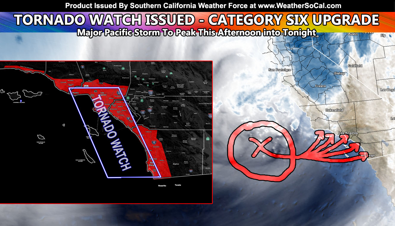
Southern California Weather Force has upgraded the Severe Thunderstorm Watch area and has issued a Tornado Watch effective this afternoon through tonight effective for Santa Barbara, Ventura, Los Angeles, Orange County, and even San Diego with the secondary thunderstorm infested impulse as the storm has now been upgraded from a category five to a category six on the SCWF 1-6 scale so read on for details …
Join the Facebook Page for Further Updates If You Have Not Yet! Lots of discussion and information there for this and future events … and yes, I even reply back to questions most of the time if I have the time!
SOUTHERN CALIFORNIA WEATHER FORCE MAIN:
The first front is moving through the forecast area. Click here for the timing in your area so I don’t need to hear you say ‘where is the storm’ in my comment section. The first front provided heavy rainfall and gusty winds through Santa Barbara and Ventura, moving into Los Angeles as well. This will exit east of the Tornado Watch area and you will see the Sun come back out. Do not be fooled, when that Sun comes out in an unstable cold-core atmosphere we get instability developing very quickly. Rare instability values for this area will happen this afternoon and evening and as this does so with the approach of the secondary impulse, the lift ahead and along it will pop off powerful thunderstorms that will produce larger hail, strong wind gusts, and even the risk of tornadoes,, hence this watch.
I’ve seen this setup before. When you get an approaching impulse in tornado alley, upsloping occurs just ahead of it in the area where the best low-level shear (veering winds) will be. This is what will happen for later today and tonight …
The last of the impulse moves through San Diego by midnight and then clears east of the area, ending the Tornado Watch
Here is a larger version of the watch (image is clickable)

REMEMBER: If you have NOT read the FINAL FORECAST ARTICLE with the detailed information, CLICK HERE and read that one and see the maps inside that pertain to your location ….
The following articles pertained to the analysis and prediction of this forecast …
March 18, 2022 – The initial prediction for the date in the long range section
FINAL FORECAST: Cold Inside Slider To Move Through Southern California This Weekend; Rain, Snow, Wind Models; Hit and Miss Expected
March 24, 2022 – The Thunderstorm wording Along With Issuing a Category Four
Strong Storm System Eyes Southern California Monday; Possibly Major Pacific Storm Status; Second Outlook
March 25, 2022 – The Official Flood Watch Issued
Flood Watch
March 25, 2022 – Numerous Thunderstorms Projected
Numerous Thunderstorms Certain To Hit Southern California Metros On Monday March 28, 2022; Flood Watch Issued
March 26, 2022 – Storm Upgraded To Category Five
Major Storm For Monday Upgraded To Category Five; Main Threat Will Be Thunderstorms For Southern California
March 27, 2022 – FINAL FORECAST for flood, rain, snow, and wind gusts
FINAL FORECAST: Major Pacific Storm To Impact Metro Southern California Monday; Flood, Rain, Snow, and Wind Models Inside
March 27, 2022 – Severe Thunderstorm Watch Issued
Severe Thunderstorm Watch Issued Monday For All Southern California Metro Zones; Wind, Hail, and Even Tornadoes Possible
How to get these alerts with a premium subscription via e-mail by micro-climate zone AND/OR Get the GPS models for this event on your device enabled? (100 percent delivery time)
Click Here To Join The Season Tier
Join The Main Southern California Weather Force Facebook Group (50 percent delivery time) – You can join the main SCWF page as well through that group.
Click Here To Join The Page Today
FACEBOOK PAGES TO JOIN!
SOUTHERN CALIFORNIA WEATHER FORCE MAIN: Southern California Weather Force Office Main Page
SOUTHERN CALIFORNIA WEATHER FORCE METEOROLOGIST: – Just my public figure page that isn’t as large so maybe you can reach me better at times.
INSTAGRAM, TWITTER, TO JOIN!
Instagram – https://www.instagram.com/socalweatherforce/
Twitter – https://twitter.com/SCweatherforce
Southern California Weather Force is a custom weather alert service that began in September 1999 off and is regarded as the most accurate weather service in the region, offering custom alerts, maps, and models to help save life and property. The work done here is never 100% accurate, but it comes pretty close. Southern California Weather Force runs on zones, so if an event happens in a zone that is 10 miles from the border of your zone, the forecast is still valid to activate your zone’s alert system. A company quote to the public is that of “The Joker” and tells other agencies in weather this all the time… “This world deserves a better class of meteorologist… and I’m gonna give it to them”… out-forecasting even the National Weather Service with lead-time and precision, which makes this service a focus of ridicule and envy in the weather community due to having such accuracy. Alerts issued here are issued custom from this office and this office alone. You may not even hear it elsewhere, but if one is issued near or in your area, listen up because “if you do not wish to die in weather, follow, it’ll save your life one day.”