
Southern California Weather Force has issued a Severe Thunderstorm Watch effective Monday as a powerful pacific storm moves in, containing strong winds, larger hail, and even the chance of tornadoes for all Southern California Metro areas so read on for details …
Zones affected will include the following; San Luis Obispo, Santa Barbara, Ventura, Los Angeles, Orange, San Diego County areas, not including Desert zones … But Does Include The ENTIRE Inland Empire …
Join the Facebook Page for Further Updates If You Have Not Yet! Lots of discussion and information there for this and future events … and yes, I even reply back to questions most of the time if I have the time!
SOUTHERN CALIFORNIA WEATHER FORCE MAIN:
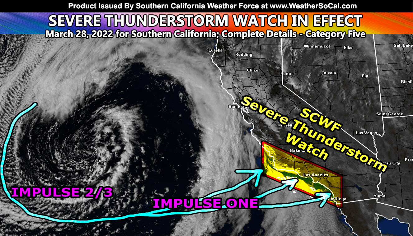
I weighed in my options on this one to either go this or tornado watch, but this will cover even the tornado wording should they happen. A powerful storm system will move through Southern California tomorrow (Monday), and carry three separate impulses with it. The previous article (CLICK HERE) has the detailed timing of each so I won’t bother adding too much that was not already read but… The first front will move through the area Monday morning through early afternoon, morning Los Angeles westward and afternoon Los Angeles eastward. This first front will be the surface front and take on a squall-line appearance through the entire area. It will look like a snake on radar once it comes through. Cold air aloft moving in with it from Santa Barbara County east through Ventura / Los Angeles County will make it likely this will start producing lightning as it moves through. The low-level winds will be out of the southeast along it and with this is the low-level shear. This can easily produce the dynamics for tornadoes to develop along it. In addition to the tornado threat, strong winds with it will be likely, probably the strongest out of the three fronts given this is the surface front that marks the boundary of the unstable/stable air.
The second and third impulses will be the afternoon/evening/night hours across the region. This will have stronger instability with it and the larger hail risks will be with these thunderstorms cells as they fire in the high Sun angle March skies. This will last almost all night for the metro areas so if you have those sensitive fur-babies then make sure they have their medication because this will be a rare and prolonged event.
All modes of severe weather will be possible all day and evening on Monday from tornadoes (even developing over the land) to larger hail, and strong winds …Keep in mind that the criteria of all alerts here at Southern California Weather Force has been adjusted to fit the Southern California area and what people will see as such …
REMEMBER: If you have NOT read the FINAL FORECAST ARTICLE with the detailed information, CLICK HERE and read that one and see the maps inside that pertain to your location ….
The following articles pertained to the analysis and prediction of this forecast …
March 18, 2022 – The initial prediction for the date in the long range section
FINAL FORECAST: Cold Inside Slider To Move Through Southern California This Weekend; Rain, Snow, Wind Models; Hit and Miss Expected
March 24, 2022 – The Thunderstorm wording Along With Issuing a Category Four
Strong Storm System Eyes Southern California Monday; Possibly Major Pacific Storm Status; Second Outlook
March 25, 2022 – The Official Flood Watch Issued
Flood Watch
March 25, 2022 – Numerous Thunderstorms Projected
Numerous Thunderstorms Certain To Hit Southern California Metros On Monday March 28, 2022; Flood Watch Issued
March 26, 2022 – Storm Upgraded To Category Five
Major Storm For Monday Upgraded To Category Five; Main Threat Will Be Thunderstorms For Southern California
March 27, 2022 – FINAL FORECAST for flood, rain, snow, and wind gusts
FINAL FORECAST: Major Pacific Storm To Impact Metro Southern California Monday; Flood, Rain, Snow, and Wind Models Inside
How to get these alerts with a premium subscription via e-mail by micro-climate zone AND/OR Get the GPS models for this event on your device enabled? (100 percent delivery time)
Click Here To Join The Season Tier
Join The Main Southern California Weather Force Facebook Group (50 percent delivery time) – You can join the main SCWF page as well through that group.
Click Here To Join The Page Today
FACEBOOK PAGES TO JOIN!
SOUTHERN CALIFORNIA WEATHER FORCE MAIN: Southern California Weather Force Office Main Page
SOUTHERN CALIFORNIA WEATHER FORCE METEOROLOGIST: – Just my public figure page that isn’t as large so maybe you can reach me better at times.
INSTAGRAM, TWITTER, TO JOIN!
Instagram – https://www.instagram.com/socalweatherforce/
Twitter – https://twitter.com/SCweatherforce
Southern California Weather Force is a custom weather alert service that began in September 1999 off and is regarded as the most accurate weather service in the region, offering custom alerts, maps, and models to help save life and property. The work done here is never 100% accurate, but it comes pretty close. Southern California Weather Force runs on zones, so if an event happens in a zone that is 10 miles from the border of your zone, the forecast is still valid to activate your zone’s alert system. A company quote to the public is that of “The Joker” and tells other agencies in weather this all the time… “This world deserves a better class of meteorologist… and I’m gonna give it to them”… out-forecasting even the National Weather Service with lead-time and precision, which makes this service a focus of ridicule and envy in the weather community due to having such accuracy. Alerts issued here are issued custom from this office and this office alone. You may not even hear it elsewhere, but if one is issued near or in your area, listen up because “if you do not wish to die in weather, follow, it’ll save your life one day.”