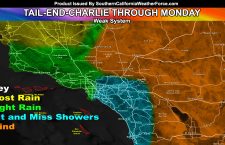
OFFICIAL: Damaging Santa Ana Winds To Return Tonight Into Thursday; San Diego Now Included
As I stated in yesterday’s article, a restart of the damaging Santa Ana Winds will happen tonight into Thursday morning, which will be more widespread from Ventura to San Diego County than earlier this week. Read on for details … There’s somewhat of a lull today, and that was expected. However, starting this evening and through the overnight winds will […]
Read more ›